List
The Western Australian State Register of Heritage Places, as of 2023 [update] , lists the following 27 state registered places within the Shire of Coolgardie:
| Place name | Place # | Street number | Street name | Suburb or town | Co-ordinates | Notes & former names | Photo |
|---|---|---|---|---|---|---|---|
| Gnarlbine Soaks (Well No.22) | 556 | Victoria Rock Road 30 km south-west of Coolgardie | Coolgardie | 31°08′50″S120°57′35″E / 31.147241°S 120.959678°E | Gnarlbine Well (Well No.22) | ||
| State Battery, Coolgardie | 557 | Battery Road | Coolgardie | 30°57′36″S121°10′45″E / 30.959992°S 121.179207°E | |||
| Original Pioneer Cemetery | 558 | Forrest Street | Coolgardie | 30°56′59″S121°09′17″E / 30.949736°S 121.15474°E | |||
| New Coolgardie Pioneer Cemetery | 559 | Great Eastern Highway | Coolgardie | 30°57′03″S121°08′41″E / 30.950792°S 121.144592°E |  | ||
| Marvel Bar Hotel (former), Coolgardie | 562 | 33 & 33A | Bayley Street | Coolgardie | 30°57′18″S121°10′08″E / 30.954999°S 121.168756°E | Marvel Loch Hotel, RSL Building |  |
| Row of 3 Shops & Lodge | 566 | 77 | Bayley Street | Coolgardie | 30°57′18″S121°09′46″E / 30.955107°S 121.162837°E | ||
| Warden's Court (former) | 568 | 61 | Sylvester Street | Coolgardie | 30°57′14″S121°09′52″E / 30.953998°S 121.164552°E | Government Building |  |
| Coolgardie Post Office & Associated Buildings | 569 | 56-60 | Bayley Street | Coolgardie | 30°57′15″S121°09′55″E / 30.95428°S 121.165394°E | Gaol, Police Station and Warden's Court, Post Office |  |
| Railway Hotel (former), Coolgardie | 570 | 75-77 | Bayley Street | Coolgardie | 30°57′18″S121°09′47″E / 30.955077°S 121.162942°E | Gold Rush Lodge, Railway Lodge, Ghost Inn Hotel, Michelle Lodge | |
| St Anthony's Convent of Mercy (former) | 573 | 85-93 | Lindsay Street | Coolgardie | 30°57′09″S121°09′42″E / 30.952483°S 121.161571°E | Convent School |  |
| Convent School (former) | 574 | 87 | Lindsay Street | Coolgardie | 30°57′09″S121°09′42″E / 30.952483°S 121.161781°E | Theatre Royal (former) | |
| House & Trees (former Warden Finnerty's House) | 577 | 2 | McKenzie Street | Coolgardie | 30°57′31″S121°10′01″E / 30.958616°S 121.16704°E | ||
| Coolgardie Primary School | 579 | Corner | Hunt & Shaw Streets | Coolgardie | 30°57′01″S121°10′00″E / 30.950146°S 121.166593°E | ||
| Coolgardie Railway Station and Goods Shed | 581 | 75 | Woodward Street | Coolgardie | 30°57′23″S121°09′45″E / 30.956437°S 121.162434°E | Railway Station (former), Museum | |
| Old Pumping Station | 583 | Great Eastern Highway | Wallaroo | 31°05′34″S120°41′36″E / 31.092729°S 120.693253°E | No 8 Pumping Station, Dedari (Benari) | ||
| Coolgardie Fire Station | 1340 | Sylvester Street | Coolgardie | 30°57′11″S121°09′52″E / 30.952962°S 121.164519°E | |||
| Peter Pan | 1737 | 69-71 | Forrest Street | Coolgardie | 30°57′00″S121°09′50″E / 30.949941°S 121.163989°E | Leighton House | |
| Toorak Hill, Goldfields Water Supply Reservoir | 3660 | Moran Street | Coolgardie | 30°56′21″S121°09′52″E / 30.939130°S 121.164493°E | Toorak Tank, Part of Goldfields Water Supply Scheme precinct (16610) | ||
| Mines Office | 3661 | Bayley Street | Coolgardie | 30°57′14″S121°09′52″E / 30.953998°S 121.164552°E | Part of Warden's Court precinct (568) | ||
| Bank | 3662 | Bayley Street | Coolgardie | 30°57′14″S121°09′52″E / 30.953998°S 121.164552°E | Part of Warden's Court precinct (568) | ||
| Museum - Ben Prior's | 3663 | 55-59 | Bayley Street | Coolgardie | 30°57′18″S121°09′55″E / 30.955076°S 121.165332°E | Part of Warden's Court precinct (568) | |
| Coolgardie Bowling Pavilion | 3664 | Corner | Sylvester & Lefroy Streets | Coolgardie | 30°57′13″S121°09′46″E / 30.953684°S 121.162915°E | Exhibition stand | |
| Coolgardie Drill Hall | 3665 | Bayley Street | Coolgardie | 30°57′14″S121°09′52″E / 30.953998°S 121.164552°E | Part of Warden's Court precinct (568) | ||
| Bullabulling Rock Water Catchment and Dams | 3933 | Reserve 2919 | Bullabulling | 31°00′41″S120°52′36″E / 31.01147°S 120.876655°E | |||
| Woolgangie Catchment, Reservoirs and Railway Settlement (ruin) | 3934 | Great Eastern Highway | Woolgangie | 31°09′48″S120°33′07″E / 31.163409°S 120.551856°E | Woolgangie Catchment and Dam | ||
| Coolgardie Sub-Branch RSL Memorial, RSL Hall | 15696 | Bayley Street | Coolgardie | 30°57′18″S121°10′08″E / 30.954999°S 121.168756°E | Part of Marvel Bar Hotel precinct (562) | ||
| Goldfields Water Supply Scheme | 16610 | Listed under the Coolgardie, Cunderdin, Kellerberrin, Kalgoorlie–Boulder, Merredin, Mundaring, Northam, Tammin and Yilgarn State Heritage lists | Stretches from Mundaring Weir in Perth to the Eastern Goldfields, particularly Coolgardie and Kalgoorlie | 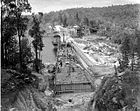 |