List of State Register of Heritage Places in the Shire of Kellerberrin

Last updated

Map all coordinates using: OpenStreetMap  
Download coordinates as: KML

The State Register of Heritage Places is maintained by the Heritage Council of Western Australia. As of 2023, 57 places are heritage-listed in the Shire of Kellerberrin, [1] of which six are on the State Register of Heritage Places. [2]

List

The Western Australian State Register of Heritage Places, as of 2023, lists the following six state registered places within the Shire of Kellerberrin:

Place namePlace #Street numberStreet nameSuburb or townCo-ordinatesNotes & former namesPhoto
Agricultural Hall (former), Kellerberrin 1369 CornerLeake & Bedford Street Kellerberrin 31°37′56″S117°43′15″E / 31.632163°S 117.720883°E / -31.632163; 117.720883 (Agricultural Hall (former), Kellerberrin) District Museum, Kellerberrin Folk Museum Kellerberrin District Museum, 2014.JPG
Kellerberrin Post Office & Residence 1372 58Massingham Street Kellerberrin 31°38′03″S117°43′07″E / 31.634064°S 117.718689°E / -31.634064; 117.718689 (Kellerberrin Post Office & Residence) Massingham Street, Kellerberrin, 2014(6).JPG
Kellerberrin Fire Station 1379 4Ripper Street Kellerberrin 31°38′03″S117°43′19″E / 31.6342°S 117.72198°E / -31.6342; 117.72198 (Kellerberrin Fire Station) Ripper Street, Kellerberrin, 2014.JPG
Hillview House Group 4045 124Massingham Street Kellerberrin 31°38′06″S117°42′35″E / 31.635071°S 117.709834°E / -31.635071; 117.709834 (Hillview House Group)
Djuringe Mooranoppin, Kellerberrin 11888 CornerGoldfields & Mission Roads Kellerberrin 31°35′39″S117°46′21″E / 31.5941°S 117.7725°E / -31.5941; 117.7725 (Djuringe Mooranoppin) Djuringe Aboriginal Mission and Reserve (former), Old Jiriny Mission, Woolundra Aboriginal Mission
Goldfields Water Supply Scheme 16610 Listed under the Coolgardie, Cunderdin, Kellerberrin, Kalgoorlie–Boulder, Merredin, Mundaring, Northam, Tammin and Yilgarn State Heritage listsStretches from Mundaring Weir in Perth to the Eastern Goldfields, particularly Coolgardie and Kalgoorlie
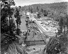
 Mundaring Weir during construction.jpg

Related Research Articles

<span class="mw-page-title-main">Shire of Kellerberrin</span> Local government area in the Wheatbelt region of Western Australia

The Shire of Kellerberrin is a local government area in the Wheatbelt region of Western Australia, about 60 kilometres (37 mi) west of Merredin and about 200 kilometres (124 mi) east of Perth, the state capital. The Shire covers an area of 1,917 square kilometres (740 sq mi) and its seat of government is the town of Kellerberrin.

References

  1. "Shire of Kellerberrin Heritage Places". inherit.stateheritage.wa.gov.au. Heritage Council of Western Australia. Retrieved 16 February 2023.
  2. "Shire of Kellerberrin State Register of Heritage Places". inherit.stateheritage.wa.gov.au. Heritage Council of Western Australia. Retrieved 16 February 2023.