List
The Western Australian State Register of Heritage Places, as of 2023 [update] , lists the following 20 state registered places within the Town of Claremont:
| Place name | Place # | Street number | Street name | Suburb or town | Co-ordinates | Notes & former names | Photo |
|---|---|---|---|---|---|---|---|
| Claremont Teachers College (former) | 482 | 50 | Goldsworthy Road | Claremont | 31°59′14″S115°47′17″E / 31.987167°S 115.788128°E | Edith Cowan University Claremont Campus, UWA Claremont | 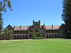 |
| Claremont Post Office | 483 | 36 | Gugeri Street | Claremont | 31°58′53″S115°46′54″E / 31.9813°S 115.7816°E | Claremont Post Office & quarters, Dome Cafe | 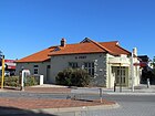 |
| Claremont Council Offices & Surroundings | 484 | 308 | Stirling Highway | Claremont | 31°59′00″S115°46′55″E / 31.983261°S 115.781809°E | Council Offices | 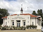 |
| Claremont Railway Station | 486 | 39 | Gugeri Street | Claremont | 31°58′51″S115°46′53″E / 31.980706°S 115.781415°E |  | |
| Congregational Hall & Congregational Church | 487 | 262-264 | Stirling Highway | Claremont | 31°58′57″S115°47′06″E / 31.982589°S 115.785117°E | 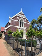 | |
| St Aidan's Uniting Church and Hall | 489 | 26 | Princess Road | Claremont | 31°59′12″S115°47′02″E / 31.986665°S 115.783848°E | Claremont Presbyterian Church, St Aidan's Presbyterian Church |  |
| Christ Church and Rectory, Claremont | 491 | 2 & 2A | Queenslea Drive | Claremont | 31°59′04″S115°46′43″E / 31.984376°S 115.778509°E |  | |
| Coronado Hotel | 492 | 206 | Stirling Highway | Claremont | 31°58′54″S115°47′25″E / 31.981796°S 115.790167°E | Highway Hotel (former) |  |
| Pillar Box | 495 | 256 | Stirling Highway | Claremont | 31°58′57″S115°47′07″E / 31.982433°S 115.785307°E | Site of Halfway Tree | 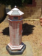 |
| Claremont Museum | 497 | 66 | Victoria Avenue | Claremont | 31°59′25″S115°47′13″E / 31.990393°S 115.787080°E | Freshwater Bay School |  |
| Colwyn, Claremont | 2080 | 50 & 50A | Victoria Avenue | Claremont | 31°59′23″S115°47′06″E / 31.989709°S 115.785118°E | Colwyn | 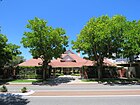 |
| Claremont School of Art Building | 4097 | 7 | Princess Road | Claremont | 31°59′10″S115°46′57″E / 31.986166°S 115.782582°E | Former Claremont Infants School, Former State Primary School |  |
| Claremont Primary School Precinct | 7596 | Bay View Terrace | Claremont | 31°59′11″S115°46′56″E / 31.986259°S 115.782123°E | Freshwater Bay Primary School |  | |
| House & Former Milk Depot | 7647 | 47 | Claremont Crescent | Swanbourne | 31°58′52″S115°46′32″E / 31.981162°S 115.775682°E | House, 47 Claremont Crescent |  |
| Oldham Residence, Swanbourne | 8091 | 11 | Saladin Street | Swanbourne | 31°58′53″S115°46′13″E / 31.981376°S 115.770231°E | 11 Saladin Street, Oldham House | |
| ANZAC Cottage, Claremont | 8094 | 16 | Saunders Street | Claremont | 31°58′47″S115°46′22″E / 31.979627°S 115.772730°E | 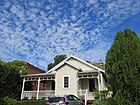 | |
| Barrett's House, Scotch College | 11977 | 76 | Shenton Road | Swanbourne | 31°58′51″S115°46′20″E / 31.980695°S 115.772284°E | Collegiate House, Administration Building, Scotch College |  |
| Christ Church Claremont Honour Roll | 15684 | Corner | Queenslea Drive & Stirling Highway | Claremont | 31°59′04″S115°46′43″E / 31.984376°S 115.778509°E |  | |
| Claremont Teachers' College War Memorial | 15686 | Goldsworthy Road | Claremont | 31°59′14″S115°47′17″E / 31.987167°S 115.788128°E |  | ||
| Claremont Teachers' College Roll of Honour | 15687 | Goldsworthy Road | Claremont | 31°59′14″S115°47′17″E / 31.987167°S 115.788128°E | In entrance hall of original college building |
