List
The Western Australian State Register of Heritage Places, as of 2021 [update] , lists the following 23 state registered places within the Shire of Narrogin:
| Place name | Place # | Street number | Street name | Suburb or town | Co-ordinates | Notes & former names | Photo |
|---|---|---|---|---|---|---|---|
| Butter Factory (former) | 1795 | 174 | Federal Street | Narrogin | 32°56′36″S117°10′44″E / 32.943348°S 117.17889°E | The Great Southern Co-operative Butter Co LtdPart of Butter Factory & Managers Residence (former), Narrogin Precinct (19879) | |
| Courthouse Museum, Narrogin | 1804 | Corner | Earl and Egerton Street | Narrogin | 32°56′01″S117°10′36″E / 32.933688°S 117.176653°E | Narrogin Courthouse, Agricultural Bank, Old Courthouse Museum, Narrogin Government School | |
| Mardoc Building, Narrogin | 1811 | 40 | Federal Street | Narrogin | 32°56′01″S117°10′43″E / 32.933666°S 117.178504°E | Cornwall Buildings |  |
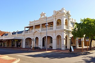
| Narrogin Town Hall Complex | 1814 | 80 | Federal Street | Narrogin | 32°56′05″S117°10′35″E / 32.934684°S 117.176313°E |  | |
| Commonwealth Bank, Narrogin | 1816 | 29 | Fortune Street | Narrogin | 32°56′06″S117°10′38″E / 32.934948°S 117.177361°E |  | |
| National Bank, Narrogin | 1817 | 27 | Fortune Street | Narrogin | 32°56′06″S117°10′39″E / 32.934992°S 117.177553°E |  | |
| Narrogin Post Office | 1818 | 22 | Fortune Street | Narrogin | 32°56′04″S117°10′40″E / 32.934495°S 117.177664°E |  | |
| Narrogin Memorial Park & War Memorial Pavilion | 1819 | 9 | Williams Road | Narrogin | 32°56′03″S117°10′30″E / 32.934259°S 117.175104°E |  | |
| Railway Houses | 1824 | 2-4 | Hale Street | Narrogin | 32°56′13″S117°10′57″E / 32.936902°S 117.182509°E | ||
| Narrogin Government Hospital (Site) | 1827 | Williams Road | Narrogin | 32°56′10″S117°10′10″E / 32.936189°S 117.169503°E | Located east of the present hospital buildings | ||
| Railway Institute Site | 3450 | Fairway Street | Narrogin | 32°56′12″S117°10′47″E / 32.936749°S 117.179847°E | |||
| Narrogin Railway Station | 3521 | 2 | Pioneer Drive | Narrogin | 32°56′08″S117°10′49″E / 32.935692°S 117.18021°E |  | |
| Main Roads Migrant Camp (former), Narrogin | 4760 | 1 | Mokine R | Narrogin | 32°56′50″S117°10′54″E / 32.947084°S 117.181675°E | Main Roads Narrogin Headquarters | |
| Railway Footbridge | 4777 | Fairway Street | Narrogin | 32°56′07″S117°10′49″E / 32.935213°S 117.180356°E |  | ||
| Railway Signal Cabin | 4778 | Fairway Street | Narrogin | 32°56′05″S117°10′48″E / 32.934753°S 117.180022°E | Demolished in 2003 | ||
| Railway Goods Shed | 4779 | 43 | Federal Street | Narrogin | 32°56′10″S117°10′48″E / 32.936109°S 117.179945°E | ||
| Railway House Narrogin (former) | 14860 | 6 | Hale Street | Narrogin | 32°56′14″S117°10′57″E / 32.937314°S 117.182495°E | ||
| Narrogin Regional Hospital | 15426 | Williams Road | Narrogin | 32°56′11″S117°10′08″E / 32.936325°S 117.168864°E | Narrogin Hospital | ||
| Cottage BN382, Dryandra | 17491 | Narrogin | Manager's House | ||||
| Manager's Residence | 18920 | 172 | Federal Street | Narrogin | 32°56′36″S117°10′44″E / 32.943348°S 117.17889°E | House 172 Federal StreetPart of Butter Factory & Managers Residence (former), Narrogin Precinct (19879) | |
| Butter Factory & Managers Residence (former), Narrogin | 19879 | 172-174 | Federal Street | Narrogin | 32°56′36″S117°10′44″E / 32.943348°S 117.17889°E | Art Deco House & Butter Factory, The Great Southern Co-operative Butter Co Ltd | |
| Railway House | 24849 | 4 | Hale Street | Narrogin | 32°56′13″S117°10′57″E / 32.936830°S 117.182524°E | ||
| Railway House | 24855 | 2 | Hale Street | Narrogin | 32°56′12″S117°10′57″E / 32.936603°S 117.182519°E |