List
The Western Australian State Register of Heritage Places, as of 2024 [update] , lists the following 20 state registered places within the City of South Perth:
| Place name | Place # | Street number | Street name | Suburb or town | Co-ordinates | Notes & former names | Photo |
|---|---|---|---|---|---|---|---|
| Wesley College, Chapel & Memorial Rose Garden | 2379 | 20 | Coode Street | South Perth | 31°58′43″S115°51′55″E / 31.978611°S 115.865278°E |  | |
| St Columba's Church Group & St Joseph's Convent, South Perth | 2383 | 25 | Forrest Street | South Perth | 31°58′42″S115°51′34″E / 31.978395°S 115.859395°E |  | |
| St Mary's Anglican Church Complex | 2385 | 9 | Ridge Street | South Perth | 31°58′58″S115°51′28″E / 31.982791°S 115.857744°E | Church Hall, St Mary's Church of the Virgin, St Mary's Close |  |
| Old Mill Theatre | 2389 | Lot 429 | Mends Street | South Perth | 31°58′25″S115°51′07″E / 31.973683°S 115.851963°E | Mechanics' Institute, Mends St Mall, Miss Burnet's School, Neeamara |  |
| South Perth Police Station (former) | 2390 | 1 | Mends Street | South Perth | 31°58′26″S115°51′04″E / 31.973764°S 115.851249°E |  | |
| Windsor Hotel | 2392 | 112 | Mill Point Road | South Perth | 31°58′23″S115°51′08″E / 31.9731°S 115.8523°E |  | |
| Old Council Offices | 2393 | 111 | Mill Point Road | South Perth | 31°58′24″S115°51′08″E / 31.973397°S 115.852132°E | Roads Board Building, South Perth Heritage House |  |
| Old Mill | 2394 | Lot 818, 833 | Mill Point Road | South Perth | 31°57′58″S115°50′49″E / 31.96616°S 115.84700°E | Shenton's Mill |  |
| Administration Building and Chapel, Aquinas College | 2396 | 58 | Mt Henry Road | Salter Point | 32°01′32″S115°51′49″E / 32.0256°S 115.8635°E |  | |
| Clontarf | 2401 | 295 | Manning Road | Waterford | 32°00′56″S115°53′34″E / 32.015618°S 115.892823°E | Clontarf Campus, St Joseph's Boys Orphanage, Clontarf Boys Town |  |
| Pagoda, Como | 2403 | 111 | Melville Parade | Como | 31°59′27″S115°51′19″E / 31.990915°S 115.855236°E | Gordon's Tea Rooms, Stardust Room, Pagoda Long Bar & Restaurant |  |
| Cygnet Cinema | 2404 | 16 | Preston Street | Como | 31°59′37″S115°51′30″E / 31.9935°S 115.8583°E | Como Theatre, Cygnet Cinema |  |
| Canning Bridge eastbound | 4659 | Canning Highway | Applecross and Como | 32°00′40″S115°51′12″E / 32.010973°S 115.853232°E | MRWA No. 913, Canning Bridge northbound/downstream. This entry and 16178 are also listed under the City of Melville as the bridge links the Cities of Melville and South Perth |  | |
| Stidworthy Residence (former) | 4689 | 130 | Mill Point Road | South Perth | 31°58′25″S115°51′13″E / 31.973744°S 115.853564°E | La Petite Noir, Ladislav's Restaurant |  |
| Narrows Bridge | 4795 | Perth & South Perth | 31°57′49″S115°50′49″E / 31.963598°S 115.846947°E | Bridge No 953 | 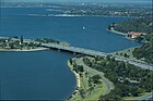 | ||
| Dennehy House (former) | 4821 | 16 | York Street | South Perth | 31°58′43″S115°51′31″E / 31.978550°S 115.858711°E | Part of the St Columba's Church Group & St Joseph's Convent Precinct (2383) |  |
| St Columba's Catholic Primary School | 7474 | 30 | York Street | South Perth | 31°58′42″S115°51′36″E / 31.978266°S 115.860023°E | Part of the St Columba's Church Group & St Joseph's Convent Precinct (2383) |  |
| Canning Bridge westbound | 9192 | Canning Highway | Applecross and Como | 32°00′40″S115°51′12″E / 32.010973°S 115.853232°E | Canning Bridge upstream, MRWA No. 912 |  | |
| Canning Bridge | 16178 | Canning Highway over the Canning River, between Applecross and Como | Applecross and Como | 32°00′40″S115°51′12″E / 32.010973°S 115.853232°E | Westbound Upstream, ref 912, Eastbound Downstream, ref 913 |  | |
| Saint Columba's Church | 24521 | 25 | Forrest Street | South Perth | 31°58′42″S115°51′37″E / 31.978202°S 115.860369°E | Part of the St Columba's Church Group & St Joseph's Convent Precinct (2383) |  |