
Western Australia is a state occupying the western 32.9 percent of the land area of Australia excluding external territories. It is bounded by the Indian Ocean to the north and west, and the Southern Ocean to the south, the Northern Territory to the north-east, and South Australia to the south-east. Western Australia is Australia's largest state, with a total land area of 2,527,013 square kilometres (975,685 sq mi), and the second-largest country subdivision in the world, surpassed only by Russia's Sakha Republic. As of 2017, the state has about 2.6 million inhabitants – around 11 percent of the national total – of whom the vast majority live in the south-west corner; 79 percent of the population lives in the Perth area, leaving the remainder of the state sparsely populated.

Protected areas of Australia include Commonwealth and off-shore protected areas managed by the Australian government, as well as protected areas within each of the six states of Australia and two self-governing territories, the Australian Capital Territory and the Northern Territory, which are managed by the eight state and territory governments.

Soil salinity and dryland salinity are two problems degrading the environment of Australia. Salinity is a concern in most states, but especially in the south-west of Western Australia.

The Government of South Australia, also referred to as the South Australian Government, SA Government or Her Majesty’s Government is the Australian state democratic administrative authority of South Australia. The Government of South Australia, a parliamentary constitutional monarchy, was formed in 1856 as prescribed in its Constitution, as amended from time to time. Since the Federation of Australia in 1901, South Australia has been a state of the Commonwealth of Australia, and the Constitution of Australia regulates its relationship with the Commonwealth. Under the Australian Constitution, South Australia ceded legislative and judicial supremacy to the Commonwealth, but retained powers in all matters not in conflict with the Commonwealth.

Kalkarindji is a town and locality in the Northern Territory of Australia, located on the Buntine Highway about 554 kilometres (344 mi) south of the territory capital of Darwin and located about 460 kilometres (290 mi) south of the municipal seat in Katherine.

Australia, officially the Commonwealth of Australia, is a sovereign country comprising the mainland of the Australian continent, the island of Tasmania, and numerous smaller islands. It is the largest country in Oceania and the world's sixth-largest country by total area. Its population of nearly 26 million is highly urbanised and heavily concentrated on the eastern seaboard. Australia's capital is Canberra, and its largest city is Sydney. The country's other major metropolitan areas are Melbourne, Brisbane, Perth, and Adelaide.
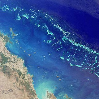
The Australian National Heritage List or National Heritage List (NHL) is a heritage register, a list of national heritage places deemed to be of outstanding heritage significance to Australia, established in 2003. The list includes natural and historic places, including those of cultural significance to Indigenous Australians such as Aboriginal Australian sacred sites. Having been assessed against a set list of criteria, once a place is put on the National Heritage List, the provisions of the Environment Protection and Biodiversity Conservation Act 1999 apply.

The Environment Protection and Biodiversity Conservation Act 1999, long title An Act relating to the protection of the environment and the conservation of biodiversity, and for related purposes, is an Act of the Parliament of Australia that provides a framework for protection of the Australian environment, including its biodiversity and its natural and culturally significant places. Enacted on 17 July 2000, it established a range of processes to help protect and promote the recovery of threatened species and ecological communities, and preserve significant places from decline. The EPBC Act is as of June 2020 administered by the Department of Agriculture, Water and the Environment. Lists of threatened species are drawn up under the Act, and these lists, the primary reference to threatened species in Australia, are available online through the Species Profile and Threats Database (SPRAT).
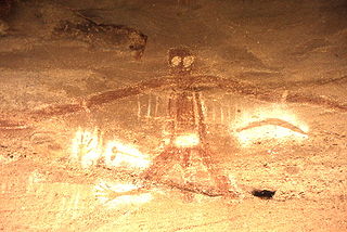
An Australian Aboriginal sacred site is a place deemed significant and meaningful by Aboriginal Australians based on their beliefs. It may include any feature in the landscape, and in coastal areas, these may lie underwater. The site's status is derived from an association with some aspect of social and cultural tradition, which is related to ancestral beings, collectively known as Dreamtime, who created both physical and social aspects of the world. The site may have its access restricted based on gender, clan or other Aboriginal grouping, or other factors.

The Commonwealth Heritage List is a heritage register established in 2003, which lists places under the control of the Australian government, on land or in waters directly owned by the Crown. Such places must have importance in relation to the natural or historic heritage of Australia, including those of cultural significance to Indigenous Australians. National heritage sites on the list are protected by the Environment Protection and Biodiversity Conservation Act 1999.
Australian heritage laws exist at the National (Commonwealth) level, and at each of Australian Capital Territory, New South Wales, Northern Territory, Queensland, South Australia, Tasmania, Victoria, Western Australia State and Territory levels. Generally there are separate laws governing Aboriginal cultural heritage and sacred sites, and historical heritage. State laws also allow heritage to be protected through local government regulations, such as planning schemes, as well.
The Historic Shipwrecks Act 1976 was an Australian Act of Parliament designed to legally protect historic shipwrecks and any relics or artefacts from those wrecks. The Act automatically affects all shipwrecks that meet the "historic" criteria and are in Australian Commonwealth waters : complementary state and territory legislation protects shipwrecks in state and territory waters including rivers and bays. Of the estimated 8,000 shipwrecks in Australian waters, more than 6,500 are protected under this legislation.

Australian Convict Sites is a World Heritage property consisting of 11 remnant penal sites originally built within the British Empire during the 18th and 19th centuries on fertile Australian coastal strips at Sydney, Tasmania, Norfolk Island, and Fremantle; now representing "...the best surviving examples of large-scale convict transportation and the colonial expansion of European powers through the presence and labour of convicts."
National biosecurity in Australia is governed and administered by two federal government departments, the Department of Health and the Department of Agriculture, Water and the Environment. The Biosecurity Act 2015 and related legislation is administered by the two departments and manages biosecurity risks at the national border. The Act aims to manage biosecurity risks to human health, agriculture, native flora and fauna and the environment. It also covers Australia's international rights and obligations, and lists specific diseases which are contagious and capable of causing severe harm to human health. Each state and territory has additional legislation and protocols to cover biosecurity in their jurisdiction (post-border).
Gretna is a rural locality in the local government areas (LGA) of Central Highlands and Derwent Valley in the Central and South-east LGA regions of Tasmania. The locality is about 20 kilometres (12 mi) south-east of the town of Hamilton. The 2016 census has a population of 211 for the state suburb of Gretna. It was formerly known as Stony Hut Plains, though the Gretna post office was known as Macquarie Plains for many years. It has a postcode of 7140.

Mount Schank is a locality in the Australian state of South Australia located about 385 kilometres south-east of the state capital of Adelaide and 14 kilometres south of the municipal seat of Mount Gambier in the south-east of the state.
The State Register of Heritage Places is the heritage register of historic sites in Western Australia deemed significant at the state level by the Heritage Council of Western Australia.
This is a list of places on the Commonwealth Heritage List in Queensland. The Commonwealth Heritage List is a heritage register which lists places of historic, cultural and natural heritage on Commonwealth land or in Commonwealth waters, or owned or managed by the Commonwealth Government. To be listed, a place has to meet one or more of the nine Commonwealth Heritage List criteria.


