List of State Register of Heritage Places in the Shire of Morawa

Last updated

Map all coordinates using: OpenStreetMap  
Download coordinates as: KML

The State Register of Heritage Places is maintained by the Heritage Council of Western Australia. As of 2021, 54 places are heritage-listed in the Shire of Morawa, [1] of which six are on the State Register of Heritage Places. [2]

List

The Western Australian State Register of Heritage Places, as of 2021, lists the following six state registered places within the Shire of Morawa:
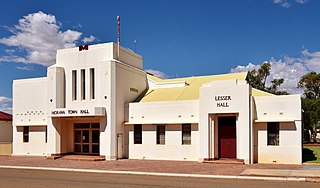
Place namePlace #Street numberStreet nameSuburb or townCo-ordinatesNotes & former namesPhoto
Church of the Holy Cross & Priest's Cell 1612 45Gill Street Morawa 29°12′43″S116°00′26″E / 29.21186°S 116.00729°E / -29.21186; 116.00729 (Church of the Holy Cross & Priest's Cell) Holy Cross Catholic Church, Morawa, 2018 (04).jpg
Morawa Shire Office & Town Hall 1620 38Prater Street Morawa 29°12′39″S116°00′27″E / 29.210932°S 116.007558°E / -29.210932; 116.007558 (Morawa Shire Office & Town Hall) Morawa shire offices and Town Hall, 2018 (01).jpg
Church of the Holy Cross 24866 45Gill Street Morawa 29°12′43″S116°00′27″E / 29.211936°S 116.007604°E / -29.211936; 116.007604 (Church of the Holy Cross) Holy Cross Catholic Church, Morawa, 2018 (05).jpg
Priest's Cell 24867 45Gill Street Morawa 29°12′43″S116°00′26″E / 29.211882°S 116.007136°E / -29.211882; 116.007136 (Priest's Cell) Holy Cross Catholic Church, Morawa, 2018 (09).jpg
Morawa Shire Offices 24868 38Prater Street Morawa 29°12′39″S116°00′27″E / 29.210932°S 116.007558°E / -29.210932; 116.007558 (Morawa Shire Office & Town Hall) Morawa shire offices, 2018 (01).jpg
Morawa Town Hall & Lesser Hall 24873 38Prater Street Morawa 29°12′39″S116°00′27″E / 29.210932°S 116.007558°E / -29.210932; 116.007558 (Morawa Shire Office & Town Hall) Morawa Town Hall, 2018 (02).jpg

Related Research Articles

<span class="mw-page-title-main">Shire of Morawa</span> Local government area in Western Australia

The Shire of Morawa is a local government area in the Mid West region of Western Australia, about 170 kilometres (106 mi) east-southeast of the city of Geraldton and about 390 kilometres (242 mi) north of the state capital, Perth. The Shire covers an area of 3,516 square kilometres (1,358 sq mi), and its seat of government is the town of Morawa.

<span class="mw-page-title-main">Shire of Perenjori</span> Local government area in Western Australia

The Shire of Perenjori is a local government area in the Mid West region of Western Australia, about 360 kilometres (224 mi) north of the state capital, Perth. The Shire covers an area of 8,313 square kilometres (3,210 sq mi), and its seat of government is the town of Perenjori.

<span class="mw-page-title-main">Shire of Three Springs</span> Local government area in Western Australia

The Shire of Three Springs is a local government area in the Mid West region of Western Australia, about 310 kilometres (193 mi) north of the state capital Perth. The Shire covers an area of 2,657 square kilometres (1,026 sq mi), and its seat of government is the town of Three Springs.

References

  1. "Shire of Morawa Heritage Places". inherit.stateheritage.wa.gov.au. Heritage Council of Western Australia. Retrieved 16 March 2021.
  2. "Shire of Morawa State Register of Heritage Places". inherit.stateheritage.wa.gov.au. Heritage Council of Western Australia. Retrieved 16 March 2021.