List of State Register of Heritage Places in the Shire of Cunderdin

Last updated

Map all coordinates using: OpenStreetMap  
Download coordinates as: KML

The State Register of Heritage Places is maintained by the Heritage Council of Western Australia. As of 2023, 29 places are heritage-listed in the Shire of Cunderdin, [1] of which five are on the State Register of Heritage Places. [2]

List

The Western Australian State Register of Heritage Places, as of 2023, lists the following five state registered places within the Shire of Cunderdin:

Place namePlace #Street numberStreet nameSuburb or townCo-ordinatesNotes & former namesPhoto
Railway Water Tower, Cunderdin 647 Lot 2Forrest Street Cunderdin 31°39′06″S117°14′29″E / 31.6516°S 117.241458°E / -31.6516; 117.241458 (Railway Water Tower, Cunderdin) Water tower, Cunderdin, 2015.JPG
No 3 Pumping Station 649 Forrest Street Cunderdin 31°39′08″S117°14′31″E / 31.652167°S 117.241848°E / -31.652167; 117.241848 (No 3 Pumping Station) Cunderdin Museum
Part of the Goldfields Water Supply Scheme precinct (16610)
Cunderdin Hall 654 Main Street Cunderdin 31°39′03″S117°14′25″E / 31.650938°S 117.240161°E / -31.650938; 117.240161 (Cunderdin Hall) Main Street, Cunderdin, 2015(4).JPG
Cunderdin Airfield 4570 82Aerodrome Road Cunderdin 31°37′13″S117°13′15″E / 31.620183°S 117.220757°E / -31.620183; 117.220757 (Cunderdin Airfield) Bellman Hangar and associated Buildings, RAAF Station (former)
Goldfields Water Supply Scheme 16610 Listed under the Coolgardie, Cunderdin, Kellerberrin, Kalgoorlie–Boulder, Merredin, Mundaring, Northam, Tammin and Yilgarn State Heritage listsStretches from Mundaring Weir in Perth to the Eastern Goldfields, particularly Coolgardie and Kalgoorlie
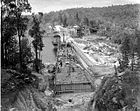
 Mundaring Weir during construction.jpg

Related Research Articles

<span class="mw-page-title-main">Shire of Cunderdin</span> Local government area in the Wheatbelt region in Western Australia

The Shire of Cunderdin is a local government area in the Wheatbelt region of Western Australia, about 105 kilometres (65 mi) west of Merredin and about 155 kilometres (96 mi) east of Perth, the state capital. The Shire covers an area of 1,864 square kilometres (720 sq mi), and its seat of government is the town of Cunderdin.

<span class="mw-page-title-main">Shire of Tammin</span> Local government area in Western Australia

The Shire of Tammin is a local government area in the Wheatbelt region of Western Australia. Its seat of government is the town of Tammin, about 80 kilometres (50 mi) west of Merredin and about 180 kilometres (112 mi) east of Perth, the state capital.

References

  1. "Shire of Cunderdin Heritage Places". inherit.stateheritage.wa.gov.au. Heritage Council of Western Australia. Retrieved 25 February 2023.
  2. "Shire of Cunderdin State Register of Heritage Places". inherit.stateheritage.wa.gov.au. Heritage Council of Western Australia. Retrieved 25 February 2023.