List
The Western Australian State Register of Heritage Places, as of 2023 [update] , lists the following 16 state registered places within the Shire of Irwin:
| Place name | Place # | Location | Suburb or town | Co-ordinates | Built | Stateregistered | Notes | Photo |
|---|---|---|---|---|---|---|---|---|
| Royal Steam Roller Flour Mill | 1210 | Waldeck Street, corner Brand Highway | Dongara | 29°14′47″S114°55′57″E / 29.246264°S 114.932557°E | 1894 | 2 July 1993 | 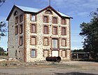 | |
| St John the Baptist Anglican Church | 1212 | 15 Waldeck Street | Dongara | 29°15′04″S114°55′50″E / 29.251159°S 114.930578°E | 1884 | 11 December 1998 |  | |
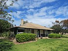
| The Grange | 1215 | Yardarino Road | Yardarino | 29°13′35″S115°02′00″E / 29.226324°S 115.033349°E | 1850 | 20 December 2002 | ||
| Old East End | 1217 | Brand Highway, 3 km E of townsite | Dongara | 29°15′06″S114°57′30″E / 29.251703°S 114.958256°E | 1868 | 24 November 2000 |
| 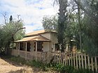 |
| Dr Bartlett's Residence (former) & Surrounds | 1221 | Ocean Drive | Port Denison | 29°15′14″S114°55′38″E / 29.253846°S 114.927095°E | 1860 | 16 December 2003 |
|  |
| Irwin Roads Board Office (former) including two Moreton Bay Fig Trees | 1227 | Point Leander Drive | Dongara | 29°15′07″S114°56′07″E / 29.251933°S 114.935285°E | 1910 | 12 July 2002 |
|  |
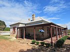
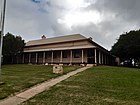
| Russ Cottage | 1230 | 260 Point Leander Drive | Port Denison | 29°15′17″S114°56′05″E / 29.254767°S 114.934842°E | 1867 | 17 October 2003 |
|  |
| Dongara Schoolmaster's House (former) | 1233 | 22 Waldeck Street | Dongara | 29°15′02″S114°55′52″E / 29.250501°S 114.931128°E | 1893 | 1 October 2002 |
|  |
| Dongara Uniting Church | 1234 | 12 Waldeck Street | Dongara | 29°15′06″S114°55′52″E / 29.251625°S 114.931216°E | 1884 | 21 January 1997 |
|  |
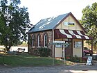
| Dongara Police Station, Courthouse & Gaol (former) | 1235 | 3 Waldeck Street | Dongara | 29°15′09″S114°55′50″E / 29.252446°S 114.930480°E | 1870 | 16 December 1994 |
|  |
| Dongara Post Office & Quarters (former) | 1236 | 7 Waldeck Street | Dongara | 29°15′08″S114°55′50″E / 29.252222°S 114.930606°E | 1894 | 5 November 1999 |
|  |
| Seventh Day Adventist Church (former) | 1240 | Corner Brand Highway & Bookara East Road | Bookara | 29°02′55″S114°51′07″E / 29.048645°S 114.851964°E | 1905 | 16 December 2003 | 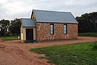 | |
| Two Obelisks and Commemorative Plaques | 1242 | Location 592 Leander Point | Port Denison | 29°16′38″S114°54′55″E / 29.277329°S 114.915347°E | 1896 | 24 April 2003 |
|  |
| Yardarino School (ruin) | 1245 | Short Street | Yardarino | 29°13′58″S115°03′30″E / 29.232889°S 115.058257°E | 1878 | 21 January 2005 |
|  |
| Moreton Terrace & Point Leander Drive Fig Trees | 4367 | Moreton Terrace & Point Leander Drive | Dongara | 29°15′05″S114°55′59″E / 29.251341°S 114.932924°E | 1906 | 27 February 2004 | 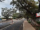 | |
| Irwin House Group | 12245 | Location 474 Midlands Road | Milo | 29°13′19″S115°06′26″E / 29.222072°S 115.107291°E | 1850 | 20 September 2002 |
|