List
The Western Australian State Register of Heritage Places, as of 2023 [update] , lists the following 13 state registered places within the Shire of Carnarvon:
| Place name | Place # | Location | Suburb or town | Co-ordinates | Built | Stateregistered | Notes | Photo |
|---|---|---|---|---|---|---|---|---|
| St George's Anglican Church | 460 | 10 Francis Street | Carnarvon | 24°53′07″S113°39′26″E / 24.885144°S 113.657353°E | 1907 | 15 October 1999 |
|  |
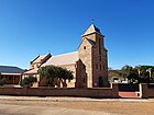
| St Mary's Star of the Sea Church | 461 | 21 Johnston Street | Carnarvon | 24°53′09″S113°39′29″E / 24.885901°S 113.658104°E | 1910 | 17 February 2006 |
|  |
| Babbage Island Lighthouse | 462 | Annear Place, Babbage Island | Carnarvon | 24°52′33″S113°37′51″E / 24.875941°S 113.630913°E | 1897 | 24 March 2000 |
|  |
| Site of the Gascoyne River Bridge | 463 | Carnarvon | 24°49′38″S113°46′08″E / 24.827155°S 113.768910°E | 1931 | 15 August 2003 |
|  | |
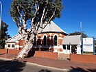
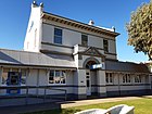
| ANZ Bank Building | 465 | 16 Robinson Street | Carnarvon | 24°53′04″S113°39′25″E / 24.884498°S 113.656928°E | 1905 | 24 March 2000 |
|  |
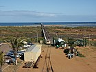
| One Mile Jetty | 467 | Babbage Island | Carnarvon | 24°52′50″S113°37′02″E / 24.880606°S 113.617145°E | 1904 |
|  | |
| Homeswest Building | 468 | 30 Robinson Street | Carnarvon | 24°53′02″S113°39′27″E / 24.883855°S 113.657462°E | 1929 | 7 January 2000 |
|  |
| Overseas Telecommunications Satellite Earth Station | 472 | Mahony Avenue Brown Range | Brown Range | 24°52′09″S113°42′19″E / 24.869086°S 113.705155°E | 1964 | 4 May 2001 |
|  |
| One Mile Jetty and Tramway | 4566 | Carnarvon | 24°52′50″S113°37′02″E / 24.880606°S 113.617145°E | 1898 | 7 February 1997 |  | ||
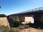
| Babbage Island Causeway Bridge | 4590 | Babbage Island Road | Carnarvon | 24°53′04″S113°39′07″E / 24.884443°S 113.651932°E | 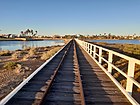 | |||
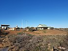
| Gascoyne Research Station | 6839 | South River Road corner Research Road | Carnarvon | 24°51′08″S113°43′47″E / 24.852293°S 113.729840°E | 1940 | 20 April 2007 |
| |
| Babbage Island Lighthouse | 25484 | Annear Place, Babbage Island | Carnarvon | 24°52′33″S113°37′51″E / 24.875941°S 113.630913°E |
|  | ||
| Tramway Bridge and Tramway | 26316 | off Olivia Terrace | Carnarvon | 24°52′02″S113°39′40″E / 24.867222°S 113.661111°E |
|  |
