List of highest mountains of Germany

Last updated

Location of the highest major summits in Germany Karte der hochsten Hauptgipfel Deutschlands.png
Location of the highest major summits in Germany

This is a list of the highest mountains in Germany. All of these mountains are located in the federal state of Bavaria. They lie within the Alps in the region known as the Eastern Alps and are part of the Northern Limestone Alps. The majority belong to the mountain ranges of the Wetterstein, Berchtesgaden Alps and Allgäu Alps.

Contents

Because the definition of a mountain is not universally agreed upon, a distinction is made between main summits and other peaks. Subsidiary summits or subpeaks are not counted. In the Alps a summit is classed as independent, according to the UIAA definition, if it has a prominence of 30 metres (98 ft) or more. In order for a peak to qualify as an independent mountain, however, it must have a prominence of at least 300 metres (980 ft). [1] Based on this definition only the main summits of entire mountain massifs are counted. All elevations with a prominence below 30 metres (98 ft) are considered as subpeaks. [2]

By these definitions, the highest mountains in Germany are the Zugspitze (2,962 m or 9,718 ft), Hochwanner (2,746 m or 9,009 ft) and Watzmann (Middle Peak, 2,713 m or 8,901 ft). If all independent summits are counted, the Zugspitze is followed by the Schneefernerkopf (2,875 m or 9,432 ft) and the Middle Wetterspitze (2,747 m or 9,012 ft) in places two and three. Both are however, part of the Zugspitze massif and lie relatively close to the summit of the Zugspitze itself.

The highest mountain which lies entirely on German soil is the Watzmann with a height of 2,713 metres (8,901 ft), followed by the Hochkalter (2,607 m or 8,553 ft), the Großer Daumen (2,280 m or 7,480 ft) and the Höfats (2,259 m or 7,411 ft). Likewise fully on German territory, but considerably less independent, are the Middle Höllentalspitze (2,742 m) and the Hochblassen (2,703 m).

A majority of the summits were verifiably climbed in the 19th century; the Watzmann and Hoher Göll for example as early as 1800. The Zugspitze was officially climbed for the first time in 1820. However, there are many peaks of which it is suspected had been climbed in earlier times by unknown climbers.

Because the borders of Germany have often changed during the course of the centuries, there were different "highest mountains" in the past. For example, during the time of the Holy Roman Empire up to 1806, the Ortler in present-day South Tyrol, at 3,905 m (12,812 ft), was the highest German mountain. During the colonial period to 1918 Mount Kilimanjaro in the colony of German East Africa, at 5,895 m (19,341 ft), was officially the highest mountain of the German Reich. During the Nazi era from 1938 to 1945 this title went to the Großglockner which, at 3,797 m (12,457 ft), is today the highest mountain in Austria.

Key

There may be differences in data from other sources. The tables use the tables of the German height reference system, based on height above Normalnull (~sea level) in Amsterdam, and data from the Bavarian Survey Office (Bayerischen Vermessungsverwaltung). [3]

The highest summits

Table 1 below shows the 30 highest independent summits in Germany. A summit or peak requires a prominence of over 30 metres (98 ft) in order to count as independent.

By clicking on the symbols at the head of the table the individual columns may be sorted.

Ranking
PhotographPeakHeight
m (ft)
Mountain rangeMassifIsolation
km (mi)
Prominence
m (ft)
First climb
1 ZugspitzeJubilaeumsgratHoellental.JPG Zugspitze 2,962 (9,718) Wetterstein Zugspitze24.6 (15.3)
Acherkogel
1,746 (5,728)
West of the Fernpass
27.08.1820
Josef Naus, Johann Georg Tauschl, Acolyte Maier1
2 Zugspitze-Schneefernerkpf1.jpg Schneefernerkopf 2,874 (9,429) Wetterstein Zugspitze1.7 (1.1)
Zugspitze
175 (574)
Schneeferner wind-gap
1871
Hermann von Barth
3 Zugspitze-Schneefernerkpf1.jpg Middle Wetterspitze 2,750 (9,020) Wetterstein Zugspitze0.6 (0.37)
Schneefernerkopf
67 (220)
Wind-gap to the Schneefernerkopf
4 Hochwanner von S HQ.jpg Hochwanner 2,744 (9,003) Wetterstein Hochwanner5.5 (3.4)
Zugspitze
701 (2,300)
Feldernjöchl
1870
Hermann von Barth
5 Hoellentalspitzen.jpg Middle Höllentalspitze 2,743 (8,999) Wetterstein Zugspitze1.6 (0.99)
Zugspitze
116 (381)
Jubiläum arête wind-gap to the Zugspitze
1871
Hermann von Barth
6 Jubilaumsgrat West HQ.jpg Inner Höllentalspitze 2,741 (8,993) Wetterstein Zugspitze0.6 (0.37)
Middle Höllentalspitze
90 (300)
Wind-gap to the Middle Höllentalspitze
09.09.1871
Hermann von Barth
7 Jubilaumsgrat Mitte von S HQ.jpg Outer Höllentalspitze 2,720 (8,920) Wetterstein Zugspitze0.6 (0.37)
Middle Höllentalspitze
35 (115)3
Wind-gap to the Middle Höllentalspitze
1871
Hermann von Barth
8 Watzmann Berchtesgaden.jpg Watzmann Middle Peak 2,713 (8,901) Berchtesgaden Alps Watzmann15.9 (9.9)
Hochseiler
939 (3,081)
Trischübel Pass
Aug. 1800
Valentin Stanič
9 Watzmann3.jpg Watzmann South Peak 2,712 (8,898) Berchtesgaden Alps Watzmann0.8 (0.50)
Watzmann Middle Peak
110 (360)3
Watzmann arête wind-gap
1832
Peter Carl Thurwieser
10 Zugspitze-Wettersteinkamm.jpg Hochblassen 2,703 (8,868) Wetterstein Zugspitze1.1 (0.68)
Outer Höllentalspitze
143 (469)
Falsche Grießkar wind-gap
25.08.1871
Hermann von Barth, Peter Klaisl
11 Zugspitze-Schneefernerkpf1.jpg Wetterwandeck 2,698 (8,852) Wetterstein Zugspitze0.5 (0.31)
Southern Wetterspitze
30 (98)
Wind-gap to the Eastern Wetterspitze
12 Leutascher Dreitorspitze MQ.jpg Leutascher Dreitorspitze 2,682 (8,799) Wetterstein Dreitorspitze5.2 (3.2)
Hochwanner
346 (1,135)
Western Wang wind-gap
07.08.1871
Hermann von Barth
13 Zugspitze-Wettersteinkamm.jpg Eastern Plattspitze 2,680 (8,790) Wetterstein Zugspitze1.1 (0.68)
Wetterwandeck
204 (669)
Wetter wind-gap
1871
Hermann von Barth
14 Hinterreintalschrofen 2,669 (8,757) Wetterstein Hochwanner1.5 (0.93)
Hochwanner
109 (358)
Teufel arête wind-gap to the Hochwanner
01.09.1871
Hermann von Barth
15 Hochfrottspitze.jpg Hochfrottspitze 2,649 (8,691) Allgäu Alps Hohes Licht 2.2 (1.4)
Hohes Licht
203 (666)
Sock valley wind-gap
16.06.1869
Hermann von Barth
16 Maedelegabel von Sueden.jpg Mädelegabel 2,645 (8,678) Allgäu Alps Hohes Licht 0.4 (0.25)
Hochfrottspitze
81 (266)
Wind-gap to the Hochfrottspitze
1852
Oskar Sendtner [4] 4
17 Partenkirchner Dreitorspitze von S aus dem Leutascher Platt HQ.jpg Partenkirchner Dreitorspitze 2,633 (8,638) Wetterstein Dreitorspitze0.5 (0.31)
Leutascher Dreitorspitze
100 (330)3
Wind-gap to the Leutascher Dreitorspitze
20.07.1854
Jakob Grasegger, Karl Kiendl
18 Alpspitze (Wetterstein).jpg Alpspitze 2,628 (8,622) Wetterstein Zugspitze0.8 (0.50)
Hochblassen
165 (541)
Grießkar wind-gap
1825
J. Burger
19 Vollkarspitze 2,618 (8,589) Wetterstein Zugspitze0.5 (0.31)
Hochblassen
40 (130)3
Wind-gap to the Höllentalspitzen
1897
Ferdinand Henning2
20 Bockkarkopf 01.jpg Bockkarkopf 2,609 (8,560) Allgäu Alps Hohes Licht 0.6 (0.37)
Hochfrottspitze
106 (348)
Bockkar wind-gap
21 Hochkaltergruppe.jpg Hochkalter 2,607 (8,553) Berchtesgaden Alps Hochkalter4.5 (2.8)
Watzmann
621 (2,037)
Wimbach wind-gap
22 Partenkirchner Dreitorspitze von S aus dem Leutascher Platt HQ.jpg Northeastern Dreitorspitze 2,605 (8,547) Wetterstein Dreitorspitze0.2 (0.12)
Dreitorspitze
40 (130)3
Wind-gap to the Dreitorspitze
23 BiberkopfII.jpg Biberkopf 2,599 (8,527) Allgäu Alps Biberkopf3.5 (2.2)
Hohes Licht
337 (1,106)
Große Stein wind-gap
18535
24 Trettachspitze.jpg Trettachspitze 2,595 (8,514) Allgäu Alps Hohes Licht 0.4 (0.25)
Mädelegabel
140 (460)3
Wind-gap to the Mädelegabel
Aug 1855
Urban, Alois and Mathias Jochum
25 Grosser Hundstod.jpg Großer Hundstod 2,593 (8,507) Berchtesgaden Alps Großer Hundstod4.5 (2.8)
Watzmann
474 (1,555)
Dießbach wind-gap
1825
Karl Thurwieser
26 Hochvogel vom jubilaeumsweg.jpg Hochvogel 2,592 (8,504) Allgäu Alps Hochvogel5.4 (3.4)
Urbeleskarspitze
572 (1,877)
Hornbachjoch
1832
Trobitus
27 Stuhljoch-Funtenseetauern.JPG Funtenseetauern 2,578 (8,458) Berchtesgaden Alps Selbhorn 4 (2.5)
Selbhorn
220 (720)
Hochbrunnsulzen
ca. 1865
Johann Grill, Albert Kaindl
28 Krottenspitze und Oefnerspitze.jpg Öfnerspitze 2,576 (8,451) Allgäu Alps Großer Krottenkopf 0.7 (0.43)
Großer Krottenkopf
161 (528)3
Wind-gap to the Großen Krottenkopf
18545
29 Wetterstein01.jpg Schüsselkarspitze 2,551 (8,369) Wetterstein Dreitorspitze0.3 (0.19)
Leutascher Dreitorspitze
60 (200)3
Wind-gap to the Leutascher Dreitorspitze
1894
A. Moser, O. Schuster
30 Krottenspitze und Krottenspitzengrat.jpg Krottenspitze 2,551 (8,369) Allgäu Alps Großer Krottenkopf0.3 (0.19)
Öfnerspitze
78 (256)
Wind-gap to the Öfnerspitze

The highest mountains

Table 2 below shows the 21 highest mountains in Germany. A mountain is considered to be the main summit of a massif if its prominence is more than 300 metres (980 ft).

By clicking the symbols at the head of the table the individual column may be sorted.

Ranking
PhotographPeakHeight
m (ft)
Mountain range4LocationIsolation
km (mi)
Prominence
m (ft)
First climb
Date
1 ZugspitzeJubilaeumsgratHoellental.JPG Zugspitze 2,962 (9,718) Wetterstein DE/AT 24.6 (15.3)
Acherkogel
1,746 (5,728)
West of the Fernpass
Josef Naus, Johann Georg Tauschl, Acolyte Maier127.08.1820
2 Hochwanner von S HQ.jpg Hochwanner 2,744 (9,003) Wetterstein DE/AT 5.5 (3.4)
Zugspitze
701 (2,300)
Feldernjöchl
Hermann von Barth 1870
3 Watzmann Berchtesgaden.jpg Watzmann Middle Peak 2,713 (8,901) Berchtesgaden Alps DE 15.9 (9.9)
Hochseiler
939 (3,081)
Trischübel Pass
Valentin Stanič Aug 1800
4 Leutascher Dreitorspitze MQ.jpg Leutascher Dreitorspitze 2,682 (8,799) Wetterstein DE/AT 5.2 (3.2)
Hochwanner
346 (1,135)
Western Wang wind-gap
Hermann von Barth 07.08.1871
5 Hochkaltergruppe.jpg Hochkalter 2,607 (8,553) Berchtesgaden Alps DE 4.5 (2.8)
Watzmann
621 (2,037)
Wimbach wind-gap
6 BiberkopfII.jpg Biberkopf 2,599 (8,527) Allgäu Alps DE/AT 3.5 (2.2)
Hohes Licht
337 (1,106)
Große Stein wind-gap
18532
7 Grosser Hundstod.jpg Großer Hundstod 2,593 (8,507) Berchtesgaden Alps DE/AT 4.5 (2.8)
Watzmann
474 (1,555)
Dießbach wind-gap
Karl Thurwieser 1825
8 Hochvogel vom jubilaeumsweg.jpg Hochvogel 2,592 (8,504) Allgäu Alps DE/AT 5.4 (3.4)
Urbeleskarspitze
572 (1,877)
Hornbachjoch
Trobitus1832
9 Vogelkarspitze bis Grabenkarspitze HQ.jpg Östliche Karwendelspitze 2,538 (8,327) Karwendel DE/AT 3.5 (2.2)
Middle Ödkarspitze
736 (2,415)
Hochalm Saddle
Hermann von Barth 04.07.1870
10 Hocheisgruppe.jpg Hocheisspitze 2,523 (8,278) Berchtesgaden Alps DE/AT 3 (1.9)
Hochkalter
410 (1,350)
Sittersbach wind-gap
Hermann von Barth 06.09.1868
11 HoherGoell.jpg Hoher Göll 2,522 (8,274) Berchtesgaden Alps DE/AT 11.4 (7.1)
Watzmann
788 (2,585)
Torrener Joch
Valentin Stanič 04.09.1800
12 Hochkarspitze Woerner MQ.jpg Hochkarspitze 2,482 (8,143) Karwendel DE/AT 42 (26)
Pleisenspitze
661 (2,169)
Bäralp Saddle
Hermann von Barth 1870
13 Die Teufelshorner.jpg Großes Teufelshorn 2,361 (7,746) Berchtesgaden Alps DE/AT 3.8 (2.4)
Reißhorn
339 (1,112)
Blühnbachtörl
14 Kahlersberg 1.jpg Kahlersberg 2,350 (7,710) Berchtesgaden Alps DE/AT 4.8 (3.0)
Großes Teufelshorn
335 (1,099)3
East of the Hintere Bärengrube
F. v. Schilcher, G. Helblehen1854
15 Stadelhorn von der Rosskarscharte.jpg Stadelhorn 2,286 (7,500) Berchtesgaden Alps DE/AT 5.2 (3.2)
Wasserwandkopf
1,133 (3,717)
Hirschbichl Pass
Karl Thurwieser 1825
16 Grosser-Daumen.jpg Großer Daumen 2,280 (7,480) Allgäu Alps DE 6.4 (4.0)
Kesselspitze
350 (1,150)
Höfatsblick summit station
17 Hoefats von Kaeseralpe.jpg Höfats 2,257 (7,405) Allgäu Alps DE 2.7 (1.7)
Großer Wilder
477 (1,565)
Älple Saddle
Otto Sendtner 1848
18 Soiernspitze.jpg Soiernspitze 2,257 (7,405) Karwendel DE 3.8 (2.4)
Wörner
833 (2,733)
West of the Vereiner-Alm
19 Ifen 250708b.jpg Hoher Ifen 2,229 (7,313) Allgäu Alps DE/AT 7.7 (4.8)
Elferkopf
476 (1,562)
Gerach Saddle
20 Grosse Arnspitze.jpg Große Arnspitze 2,196 (7,205) Wetterstein DE/AT 3.9 (2.4)
Upper Wetterstein peak
1,003 (3,291)
Northwest of Neuleutasch
21 Kreuzspitze von S HQ.jpg Kreuzspitze 2,185 (7,169) Ammergau Alps DE 10.6 (6.6)
Daniel
1,182 (3,878)
Upper Schellbach valley

See also

Related Research Articles

<span class="mw-page-title-main">Zugspitze</span> Highest peak of the Wetterstein Mountains (Eastern Alps)

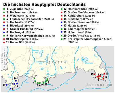
The Zugspitze, at 2,962 m (9,718 ft) above sea level, is the highest peak of the Wetterstein Mountains and the highest mountain in Germany. It lies south of the town of Garmisch-Partenkirchen in Bavaria, and the Austria–Germany border is on its western summit. South of the mountain is the Zugspitzplatt, a high karst plateau with numerous caves. On the flanks of the Zugspitze are two glaciers, the largest in Germany: the Northern Schneeferner with an area of 30.7 hectares and Höllentalferner with an area of 24.7 hectares. Shrinking of the Southern Schneeferner led to the loss of glacier status in 2022.

<span class="mw-page-title-main">Watzmann</span> Mountain in Germany

The Watzmann is a mountain in the Berchtesgaden Alps south of the village of Berchtesgaden. It is the third highest in Germany, and the highest located entirely on German territory.

<span class="mw-page-title-main">Topographic isolation</span> Topography measuring minimum distance to a point of equal elevation

The topographic isolation of a summit is the minimum distance to a point of equal elevation, representing a radius of dominance in which the peak is the highest point. It can be calculated for small hills and islands as well as for major mountain peaks and can even be calculated for submarine summits. Mount Everest, the highest point on Earth, has an undefined isolation, since there are no higher points to reference.

<span class="mw-page-title-main">Wetterspitzen</span> Mountain ridge in the Wetterstein mountains in Germany

The Wetterspitzen are three of the rocky peaks on a mountain ridge in the Wetterstein mountains in the central part of the Eastern Alps in Germany. They lie two kilometres, as the crow flies, southwest of Germany's highest peak, the Zugspitze, on the border between the Austrian province of Tyrol and the German state of Bavaria. The Wetterspitzen form the southwest perimeter of the Zugspitze ledge (Zugspitzplatt); below and to the east is the ski region on the Schneeferner with its research station, the Schneefernerhaus.

<span class="mw-page-title-main">Schneefernerkopf</span>

The Schneefernerkopf is a 2,875-metre-high (9,432 ft) peak in the Zugspitze massif in the Alps. It lies at the western end of the Wetterstein chain in the Alps on the border between the German state of Bavaria and the Austrian state of Tyrol. It is the dominant mountain in the Wetterstein, especially when viewed from Ehrwald.

<span class="mw-page-title-main">Hochwanner</span>

At 2,744 metres (9,003 ft), the Hochwanner is the second highest mountain in Germany after the Zugspitze. In addition the Hochwanner is the highest peak on the main ridge of the Wetterstein (Wettersteinhauptkamm) running from Gatterl to the Upper Wettersteinspitze above Mittenwald in an east–west direction. From the Hochwanner massif there is an all-round view of the Rein valley (Reintal), the Leutasch valley in Austria, the Gais valley, the Zugspitze, the Mieming Chain, the Jubiläumsgrat, the Karwendel mountains and far into the central Alps.

<span class="mw-page-title-main">Hochblassen</span>

The Hochblassen is a mountain 2,706 metres (8,878 ft) high, located in the Wetterstein in the German state of Bavaria. In addition to the main summit, it has a sub-peak, the so-called Signalgipfel which is 2,698 metres (8,852 ft) high. It was first climbed in 1871 by Hermann von Barth and Peter Klaisl.

<span class="mw-page-title-main">Wetterwandeck</span>

The Wetterwandeck is a summit, 2,698 m high, in the Wetterstein mountains on the Austro-German border. It is located south of Germany's highest peak, the Zugspitze, above the Southern Schneeferner in the ridge which borders the Zugspitzplatt to the south.

<span class="mw-page-title-main">Ellmauer Halt</span> Mountain peak in the Kaiser range in Tyrol, Austria

The Ellmauer Halt (2,344 m) is the highest peak in the mountain massif of the Wilder Kaiser in the Kaiser range in the Austrian state of Tyrol. To the east is the summit of the Kapuzenturm, a striking and isolated rock pinnacle. In 1883 the first summit cross was erected on the mountain top.

<span class="mw-page-title-main">Große Arnspitze</span>

The Große Arnspitze is the highest peak in the Arnspitze Group in the Wettersteingebirge mountains. It is located west of Scharnitz in Austria. The border between Germany and Austria runs over its summit.

<span class="mw-page-title-main">Hoher Göll</span> Mountain on the Austrian-German border

The Hoher Göll is a 2,522 m (8,274 ft) mountain in the Berchtesgaden Alps. It is the highest peak of the Göll massif, which straddles the border between the German state of Bavaria and the Austrian state of Salzburg.

<span class="mw-page-title-main">Hocheisspitze</span>

The Hocheisspitze is a 2,523 m high mountain in the Berchtesgaden Alps, over which the border between Germany and Austria runs. It is also the highest mountain in the eponymous Hocheis Group that belongs to the Hochkalter Massif.

<span class="mw-page-title-main">First Schafalpenkopf</span>

The First Schafalpenkopf or Southwestern Schafalpenkopf is a 2,272-metre-high mountain in the Allgäu Alps. It is part of the Schafalpenköpfe and the Mindelheim Klettersteig.

<span class="mw-page-title-main">Steinernes Meer</span>

The Steinernes Meer is a high karst plateau in the Northern Limestone Alps. As one of the nine sub-ranges of the Berchtesgaden Alps the Steinernes Meer belongs partly to Bavaria and partly to Salzburg.

<span class="mw-page-title-main">Daniel (mountain)</span>

The Daniel is a mountain in the Austrian state of Tyrol, and the highest peak in the Ammergau Alps, a range within the Northern Limestone Alps . Located near the villages of Ehrwald and Lermoos, it is a popular mountain with hikers. Its North Face is around 200 metres high and its South Face has a more schrofen-like character. With the almost equally high Upsspitze (2,332 m) it forms a double summit. To the northwest is a neighbouring peak, the Hochschrutte (2,247 m).

<span class="mw-page-title-main">Second Schafalpenkopf</span>

The Second Schafalpenkopf, also Middle Schafalpenkopf is a 2,302-metre-high mountain in the Allgäu Alps. It is part of the Schafalpenköpfe and the Mindelheim Klettersteig.

<span class="mw-page-title-main">Gehrenspitze (Allgäu Alps)</span>

At 2,163 metres, the Gehrenspitze is the third highest mountain in the Tannheim Group and is situated in the Austrian state of Tyrol. It should not be confused with the Gehrenspitze in the Wetterstein Mountains.

References

  1. Or a prominence of 100m according to other authorities.
  2. "The Viertausender of the Alpen – Offizielles UIAA-Verzeichnis" (PDF) (in German). UIAA. March 1994. Retrieved 7 May 2009.
  3. Bayerische Vermessungsverwaltung. "Bayernviewer". Bayerische Staatsregierung. Archived from the original on 27 March 2009. Retrieved 19 May 2009.
  4. "Von Abenteurern and Bergpionieren". allgaeuer-anzeigeblatt.de. 2005. Archived from the original on 18 July 2011. Retrieved 6 May 2009.
  5. 1 2 Andrea Händel (2006). "Historische Zugspitzkarte". alpenverein.de. Archived from the original on 11 March 2007. Retrieved 6 May 2009.

Literature