List of lakes in Pope County, Arkansas

Last updated
Map all coordinates using: OpenStreetMap  ·  Google Maps
Download coordinates as: KML  ·  GPX

There are at least 21 named lakes and reservoirs in Pope County, Arkansas .

Lake A body of relatively still water, in a basin surrounded by land

A lake is an area filled with water, localized in a basin, that is surrounded by land, apart from any river or other outlet that serves to feed or drain the lake. Lakes lie on land and are not part of the ocean, and therefore are distinct from lagoons, and are also larger and deeper than ponds, though there are no official or scientific definitions. Lakes can be contrasted with rivers or streams, which are usually flowing. Most lakes are fed and drained by rivers and streams.

Reservoir A storage space for fluids

A reservoir is, most commonly, an enlarged natural or artificial lake, pond or impoundment created using a dam or lock to store water.
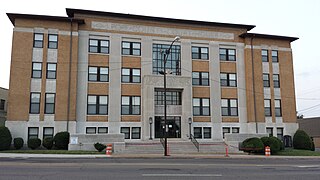
Pope County, Arkansas County in the United States

Pope County is a county in the U.S. state of Arkansas. As of the 2010 census, the population was 61,754. The county seat is Russellville. The county was formed on November 2, 1829, from a portion of Crawford County and named for John Pope, the third governor of the Arkansas Territory. It is an alcohol prohibition or dry county.

Contents

Lakes

Reservoirs

Winthrop Rockefeller Lake is an impounded section of the Arkansas River, named for Governor Winthrop A. Rockefeller (1912–1973). It extends almost 30 miles (50 km) along the river, from the Arthur V. Ormond Lock and Dam below Mile 177 near Morrilton, to the Dardanelle Lock and Dam above Mile 205 near Dardanelle. Lake Dardanelle begins immediately above Rockefeller Lake.

See also

Notes

  1. "Flagg Lake". Geographic Names Information System . United States Geological Survey.
  2. "Holla Bend". Geographic Names Information System . United States Geological Survey.
  3. "Lodge Lake". Geographic Names Information System . United States Geological Survey.
  4. "Long Lake". Geographic Names Information System . United States Geological Survey.
  5. "Galla Creek Lake". Geographic Names Information System . United States Geological Survey.
  6. "Galla Creek Wildlife Lake". Geographic Names Information System . United States Geological Survey.
  7. "Galla Watershed Site One Reservoir". Geographic Names Information System . United States Geological Survey.
  8. "Jones Lake". Geographic Names Information System . United States Geological Survey.
  9. "Lake Atkins". Geographic Names Information System . United States Geological Survey.
  10. "Lake Irvin". Geographic Names Information System . United States Geological Survey.
  11. "Lake Russellville". Geographic Names Information System . United States Geological Survey.
  12. "Lake Vinson". Geographic Names Information System . United States Geological Survey.
  13. "Lake Yarbrough". Geographic Names Information System . United States Geological Survey.
  14. "West Fork Point Remove Creek Site 10 Reservoir". Geographic Names Information System . United States Geological Survey.
  15. "West Fork Point Remove Creek Site 11 Reservoir". Geographic Names Information System . United States Geological Survey.
  16. "West Fork Point Remove Creek Site 17 Reservoir". Geographic Names Information System . United States Geological Survey.
  17. "West Fork Point Remove Creek Site 18 Reservoir". Geographic Names Information System . United States Geological Survey.
  18. "West Fork Point Remove Creek Site 19 Reservoir". Geographic Names Information System . United States Geological Survey.
  19. "West Fork Point Remove Creek Site Eight Reservoir". Geographic Names Information System . United States Geological Survey.
  20. "West Fork Point Remove Creek Site Nine Reservoir". Geographic Names Information System . United States Geological Survey.
  21. "Winthrop Rockefeller Lake". Geographic Names Information System . United States Geological Survey.