Willows Gemfields is a rural town in the locality of Willows in the Central Highlands Region of Queensland, Australia. In the 2021 census, the town of Willows Gemfields had a population of 101 people.

Sorell is a town in Tasmania, Australia, north-east of Hobart. It is located on the Tasman Highway at the junction with the Arthur Highway. Sorell is one of Tasmania's oldest towns, being first settled in 1808 as a small farming community and becoming an official township in 1821. At the 2006 census, Sorell had a population of 1,546, and at the 2011 census, a population of 2,476. and at the 2016 census, a population of 2,907.

The City of Wanneroo is a local government area with city status in the northern suburbs of Perth, Western Australia. It is centred approximately 25 kilometres (15.5 mi) north of Perth's central business district and forms part of the northern boundary of the Perth metropolitan area. Wanneroo encompasses the federal divisions of Cowan, Moore and Pearce.

Hobart City Council is a local government body in Tasmania, covering the central metropolitan area of the state capital, Hobart. The Hobart local government area has a population of 53,684 and includes the suburbs of West Hobart, Lenah Valley, Mount Stuart, South Hobart, New Town, Sandy Bay and most of Fern Tree, North Hobart and Mount Nelson.
The suburbs of the Australian Capital Territory are organised into a hierarchy of districts, town centres, group centres, local suburbs and other industrial areas and villages. While these divisions have no formal role in the governance or administration of the city, they formed a basis for the planning and development of the city and are significant to the city's commercial and social activities.

Woodbridge is a semi-rural locality in the local government area (LGA) of Kingborough in the Hobart LGA region of Tasmania. The locality is about 26 kilometres (16 mi) south of the town of Kingston. The 2021 Census recorded a population of 547 for the state suburb of Woodbridge, with the median age being 54. There are 180 families living in Woodbridge, with a mean of 1.8 children per household. It is located 38 kilometres (24 mi) south of the state capital, Hobart.
One Night Stand is an annual music festival held in various regional Australian cities and towns that is promoted and organised by national youth radio station Triple J. The event ran for 15 years from its debut in 2004 until 2019, with one break in 2015 for Triple J's 30th anniversary Beat the Drum event. The COVID-19 pandemic prevented any large-scale music festivals in 2020 and 2021, yet the One Night Stand did not return once restrictions on major events were lifted. After a spate of cancellations of major Australian music festivals, the return of the festival was announced by Triple J on the 8th of April 2024. One Night Stand returned to Warrnambool, Victoria on 14 September 2024.

The Hay Shire is a local government area in the Riverina area of south-western New South Wales, Australia. The Shire comprises 11,326 square kilometres (4,373 sq mi) and is located adjacent to the Sturt, Mid-western and Cobb Highways. The area includes the towns of Hay, Booligal and Maude.

The City of Kalamunda is a local government area in the eastern metropolitan region of the Western Australian capital city of Perth about 25 kilometres (16 mi) east of Perth's central business district. The area covers 324 square kilometres (125 sq mi), much of which is state forest rising into the Darling Scarp to the east. As of 2021, the city had a population of 58,762.

Sorell Council is a local government body in Tasmania, situated in the south-east of the state. The Sorell local government area is classified as rural and has a population of 15,218. The major centres of the region include Dodges Ferry, Dunalley, Primrose Sands and the principal town of Sorell.
The Shire of Barcoo is a local government area in Central West Queensland, Australia.

The Shire of McKinlay is a local government area in outback north-western Queensland, Australia.

The Shire of Flinders is a local government area in north-western Queensland, Australia.
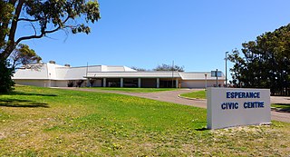
The Shire of Esperance is a local government area in the Goldfields–Esperance region of Western Australia, about 400 kilometres (250 mi) south of the town of Kalgoorlie and about 720 kilometres (450 mi) east-southeast of the state capital, Perth. The Shire covers an area of 42,547 square kilometres (16,427 sq mi), and its seat of government is the town of Esperance, where about three-quarters of the Shire's population resides.

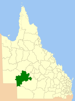
The Goondiwindi Region is a local government area located in the Darling Downs region of Queensland, Australia along the state's border with New South Wales. Established in 2008, it was preceded by three previous local government areas which dated back to the 19th century.

Canberra is Australia's capital and its largest inland city. At the 2021 census, it had 452,670 residents. This amounted to 1.8% of Australia's population.
Colebrook is a rural locality and town in the local government area of Southern Midlands in the Central region of Tasmania. It is located about 29 kilometres (18 mi) south of the town of Oatlands. The 2021 census gave a population of 372 for Colebrook.


