
The Falkland Islands are located in the South Atlantic Ocean between 51°S and 53°S on a projection of the Patagonian Shelf, part of the South American continental shelf. In ancient geological time this shelf was part of Gondwana, and around 400 million years ago split from what is now Africa and drifted westwards from it. Today the islands are subjected to the Roaring Forties, winds that shape both their geography and climate.

The Falkland Islands wolf, also known as the warrah and occasionally as the Falkland Islands dog, Falkland Islands fox, warrah fox, or Antarctic wolf, was the only native land mammal of the Falkland Islands. This endemic canid became extinct in 1876, the first known canid to have become extinct in historical times.

West Falkland is the second largest of the Falkland Islands in the South Atlantic. It is a hilly island, separated from East Falkland by the Falkland Sound. Its area is 4,532 square kilometres, 37% of the total area of the islands. Its coastline is 1,258.7 kilometres long.
Saunders Island is the fourth largest of the Falkland Islands, lying north west of West Falkland. The island is run as a sheep farm.

The Jason Islands are an archipelago in the Falkland Islands, lying to the far north-west of West Falkland. Three of the islands, Steeple Jason, Grand Jason and Clarke's Islet, are private nature reserves owned by the Wildlife Conservation Society of New York City. Other islands in the group are National Nature Reserves owned by the Falkland Islands Government.

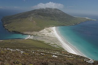
West Point Island is one of the Falkland Islands, lying in the north-west corner of the archipelago. It has an area of 1,469 hectares (5.67 sq mi) and boasts some of the most spectacular coastal scenery in the Falklands. The island is owned by Roddy & Lily Napier and run as a sheep farm and tourist attraction.
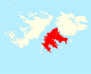
Lafonia is a peninsula forming the southern part of East Falkland, the largest of the Falkland Islands.

Port Egmont was the first British settlement in the Falkland Islands, on Saunders Island off West Falkland, and is named after John Perceval, 2nd Earl of Egmont, who was First Lord of the Admiralty at the time of its founding.

The Falkland Islands is an archipelago in the South Atlantic Ocean on the Patagonian Shelf. The principal islands are about 300 mi (480 km) east of South America's southern Patagonian coast and about 752 mi (1,210 km) from Cape Dubouzet at the northern tip of the Antarctic Peninsula, at a latitude of about 52°S. The archipelago, with an area of 4,700 sq mi (12,000 km2), comprises East Falkland, West Falkland, and 776 smaller islands. As a British overseas territory, the Falklands have internal self-governance, but the United Kingdom takes responsibility for their defence and foreign affairs. The capital and largest settlement is Stanley on East Falkland.
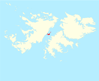
The Swan Islands are a small group of islands in the middle of Falkland Sound in the Falkland Islands, and comprising Swan Island and the smaller West Swan Island and North Swan Island.

Hill Cove is the third largest settlement on West Falkland, in the Falkland Islands, in the north-west. It is on the north coast, on the shore of Byron Sound, and overlooks Port Egmont on Saunders Island, the first British settlement in the islands. Behind the settlement is Mount Adam, which shelters it from southerly winds.
The Falklands Crisis of 1770 was a diplomatic standoff between Great Britain and Spain over possession of the Falkland Islands in the South Atlantic Ocean. These events were nearly the cause of a war between Britain and Spain—backed by France—and all three countries were poised to dispatch armed fleets to defend the rival claims to sovereignty of the barren but strategically important islands.

Mount Kent is a hill on East Falkland, Falkland Islands, and is 458 m high. It is located north of Mount Challenger.
Split Island is one of the Falkland Islands. It is near West Falkland, to its west, at the mouth of King George Bay. It is to the west of Rabbit Island, Hummock Island and Middle Island. It is north of the Passage Islands and south east of Westpoint Island, and south west of the Byron Heights and Storm Mountain.
Dunbar Island is part of the West Point Island Group of the Falkland Islands. It is near West Falkland, to its north, in Byron Sound. It is east of Carcass Island and Low Island and to the west of Saunders Island. It is south of Sedge Island and north of the Byron Heights and Storm Mountain.
Broken Island is one of the Falkland Islands, in Byron Sound, due north of West Falkland.
Passage Island is one of Falkland Islands, in Byron Sound, to the north of West Falkland. It is not to be confused with the Passage Islands which are to the west of West Falkland. It is to the west of Golding Island.
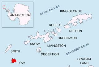
Jameson Point is a small headland on the north side of the entrance to Malina Cove, situated 6.3 km (3.9 mi) north of Cape Garry on the west side of Low Island, in the South Shetland Islands of Antarctica. It was roughly charted by the French Antarctic Expedition, 1908–10. The point was photographed from the air by the Falkland Islands and Dependencies Aerial Survey Expedition, 1955–57, and more accurately delineated from these photos by the Falkland Islands Dependencies Survey in 1959. The name "Jameson Island" was applied to Low Island by James Weddell in 1820–23, and Jameson Point has been approved for this point to preserve Weddell's name on Low Island.

Mount Alice is a mountain rising to 361 m (1,180 ft) at the south extremity of West Falkland, Falkland Islands in the South Atlantic. It is situated between the bays of Port Stephens and Port Albemarle, 12.3 km (7.6 mi) due north of Cape Meredith.
Byron Heights is a mountain rising to 497 m (1,630 ft) at the northwest extremity of West Falkland, Falkland Islands in the South Atlantic. It is situated 11.65 km (7.24 mi) southeast of Hope Point.
