
North 24 Parganas (abv. 24 PGS (N)) or sometimes North Twenty Four Parganas is a district in southern West Bengal, of eastern India. North 24 Parganas extends in the tropical zone from latitude 22° 11′ 6″ north to 23° 15′ 2″ north and from longitude 88º20' east to 89º5' east. Barasat is the district headquarters of North 24 Parganas. North 24 Parganas is West Bengal's most populous district and also (since 2014) the most populated district in the whole of India. It is the tenth-largest district in the State by area.
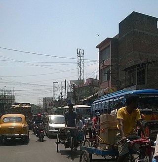
Habra is a city and a municipality under Barasat sadar subdivision in North 24 Parganas district of the Indian state of West Bengal. It is situated on the Jessore Road between Kolkata and the Bangladesh border at Petrapole. Its location makes it an important town for export and import of goods between India and Bangladesh.

Gobardanga is a city and a municipality in North 24 Parganas district in the Indian state of West Bengal. Founded on 20 April 1870, it is one of the oldest municipalities of West Bengal.

Naihati is a city and a municipality of North 24 Parganas district in the Indian state of West Bengal. It is situated in the northern part of Kolkata Metropolitan Area under the supervision of Kolkata Metropolitan Development Authority (KMDA). It is an important industrial and commercial hub in Hooghly Industrial Belt and Kolkata conurbation.
Ashoknagar Kalyangarh is a city and a municipality in Barasat Sadar subdivision of North 24 Parganas district in the state of West Bengal, India. Ashoknagar is the first discovered oilfield in West Bengal and East India. The oilfield was discovered in 2018 by ONGC.
Bara Bamonia is a census town in the Habra II CD block of Barasat Sadar subdivision in North 24 Parganas district in the state of West Bengal, India.
Guma is a census town(CT) in the Habra II CD block of Barasat sadar subdivision in North 24 Parganas district in the Indian state of West Bengal.
Maslandpur (also spelled as “Maslandpur” “Maslandpur” "Maslandpur" is is a Suburban in the Habra I CD block in Barasat sadar subdivision in North 24 Parganas district in the Indian state of West Bengal.
Nokpul is a census town in the Habra I CD block in the Barasat sadar subdivision in the North 24 Parganas district in the Indian state of West Bengal.
Sadpur is a census town in the Habra I CD block in the Barasat Sadar subdivision in the North 24 Parganas district in the Indian state of West Bengal.
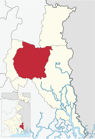
Barasat Sadar subdivision is an administrative subdivision of the North 24 Parganas district in the Indian state of West Bengal. After transferring Rajarhat-Gopalpur Municipality and Rajarhat to Bidhannagar subdivision, Barasat Sadar subdivision's total area became 894.61 km2, population became 2,196,874 and density became 2,500/km2.

Barasat I is a community development block that forms an administrative division in Barasat Sadar subdivision of North 24 Parganas district in the Indian state of West Bengal.

Habra I is a community development block that forms an administrative division in Barasat Sadar subdivision of North 24 Parganas district in the Indian state of West Bengal.

Habra II is a community development block that forms an administrative division in Barasat Sadar subdivision of North 24 Parganas district in the Indian state of West Bengal.
Sabdalpur is a village in the Habra II CD block in the Barasat Sadar subdivision of the North 24 Parganas district in the state of West Bengal, India.
Betpuli is a census town in the Habra I CD block in the Barasat Sadar subdivision of the North 24 Parganas district in the state of West Bengal, India.
Anarbaria is a census town in the Habra I CD block in the Barasat Sadar subdivision of the North 24 Parganas district in the state of West Bengal, India.
Purba Narayanpur is a census town in the Habra I CD block in the Barasat Sadar subdivision of the North 24 Parganas district in the state of West Bengal, India.
Khorddabamonia is a census town in the Habra II CD block in the Barasat Sadar subdivision of the North 24 Parganas district in the state of West Bengal, India.
Bira is a census town in the Habra II CD block in the Barasat Sadar subdivision of the North 24 Parganas district in the state of West Bengal, India.


