Colfax Avenue is the main street that runs east–west through the Denver metropolitan area in Colorado. As U.S. Highway 40, it was one of two principal highways serving Denver before the Interstate Highway System was constructed. In the local street system, it lies 15 blocks north of the zero meridian, and would thus otherwise be known as 15th Avenue. The street was named for the 19th-century politician Schuyler Colfax. At just over 50 miles in length, it is known as the "longest continuous commercial street in America."

Orangeville is a village in Stephenson County, Illinois, United States. The town's sign lists the population at 800 as of January 2021. The population in 2020 was 738. The population according to the 2010 census was 793, up from 751 in 2000. Using the 2020 population of 738 Orangeville is the 741st largest city in Illinois and the 11,650th largest city in the United States. Orangeville is currently declining at a rate of -0.94% annually and its population has decreased by -6.94% since the 2010 census. The area's earliest white settlers arrived in the year 1833, and the village was platted in 1851 by John Bower, who is considered the village founder. In 1867 Orangeville was incorporated as a village. The town's central business district contains several 19th century commercial buildings, many of which were built during the railroad boom of 1888–1914. By the time the Great Depression was ongoing, business in Orangeville had started to decline, with the last bank closing in 1932. In 1956 another bank started operating in the village and is still in town today. Some recent infrastructure jumps have restored some of the village's old decor.

Portage is a city in and the county seat of Columbia County, Wisconsin, United States. The population was 10,581 at the 2020 census, making it the largest city in Columbia County. The city is part of the Madison Metropolitan Statistical Area.

Mequon is the largest city in Ozaukee County, in the U.S. state of Wisconsin, and the third-largest city in Wisconsin by land area. Located on Lake Michigan's western shore with significant commercial developments along Interstate 43, the community is a suburb in the Milwaukee metropolitan area. Despite being an incorporated city, approximately half of Mequon's land is undeveloped and agriculture plays a significant role in the local economy. At the time of the 2010 census the population was 23,132.

Thiensville is a village in Ozaukee County, Wisconsin, United States. Located on the west bank of a bend in the Milwaukee River, the community is bordered on all sides by the City of Mequon and is a suburb in the Milwaukee metropolitan area. The population was 3,235 at the 2010 census.
A central business district (CBD) is the commercial and business centre of a city. It contains commercial space and offices, and in larger cities will often be described as a financial district. Geographically, it often coincides with the "city centre" or "downtown". However, these concepts are not necessarily synonymous: many cities have a central business district located away from its commercial and or cultural center and or downtown/city center, and there may be multiple CBDs within a single urban area. The CBD will often be characterised by a high degree of accessibility as well as a large variety and concentration of specialised goods and services compared to other parts of the city. For instance, Midtown Manhattan, New York City, is the largest central business district in the city and the United States. London's city center is usually regarded as encompassing the historic City of London and the medieval City of Westminster, while the City of London and the transformed Docklands area containing Canary Wharf are regarded as their two respective CBDs. In Chicago, the Chicago Loop is the second-largest central business district in the United States. It is also referred to as the core of the city's downtown. Mexico City also has its own historic city center, the colonial-era "Centro Histórico", along with two CBDs: the mid-late 20th century Paseo de la Reforma – Polanco, and the new Santa Fe, respectively. Moscow and Russia's largest central business district is the Moscow International Business Center.

M-1, commonly known as Woodward Avenue, is a north–south state trunkline highway in the Metro Detroit area of the US state of Michigan. The highway, called "Detroit's Main Street", runs from Detroit north-northwesterly to Pontiac. It is one of the five principal avenues of Detroit, along with Michigan, Grand River, Gratiot, and Jefferson avenues. These streets were platted in 1805 by Judge Augustus B. Woodward, namesake to Woodward Avenue. The Federal Highway Administration (FHWA) has listed the highway as the Automotive Heritage Trail, an All-American Road in the National Scenic Byways Program. It has also been designated a Pure Michigan Byway by the Michigan Department of Transportation (MDOT), and was also included in the MotorCities National Heritage Area designated by the US Congress in 1998.

Wakefield is a village in the town of South Kingstown, Rhode Island, United States, and the commercial center of South Kingstown. Together with the village of Peace Dale, it is treated by the U.S. Census as a component of the census-designated place identified as Wakefield-Peacedale, Rhode Island. West Kingston, another South Kingstown village, was the traditional county seat of Washington County. Since 1991, the Washington County Courthouse has been in Wakefield. The Sheriff's Office which handles corrections is also in Wakefield.
Lincoln Park is one of the larger neighborhoods in the city of Duluth, Minnesota, United States.

Homestead High School is a four-year public high school located in Mequon, Wisconsin, United States, a northern suburb of Milwaukee. Part of the Mequon-Thiensville School District, it serves a 48-square-mile (120 km2) area including the city of Mequon and the village of Thiensville. The school opened in 1959 and educates nearly 1,300 students annually. Its graduation rate is 99%, and its most recent average composite ACT scores were 23.4, the seventeenth-highest of any public school in the state. Homestead is accredited by the North Central Association of Colleges and Schools.

The neighborhoods of Milwaukee include a number of areas in southeastern Wisconsin within the state's largest city at nearly 600,000 residents.

Downtown Paterson is the main commercial district of Paterson, Passaic County, in the U.S. state of New Jersey. The area is the oldest part of the city, along the banks of the Passaic River and its Great Falls. It is roughly bounded by Interstate 80, Garret Mountain Reservation, Route 19, Oliver Street, and Spruce Street on the south; the Passaic River, West Broadway, Cliff Street, North 3rd Street, Haledon Avenue, and the borough of Prospect Park on the west; and the Passaic River also to the north.

Downtown Norfolk serves as the traditional center of commerce, government, and culture in the Hampton Roads region. Norfolk, Virginia's downtown waterfront shipping and port activities historically played host to numerous and often noxious port and shipping-related uses. With the advent of containerized shipping in the mid-19th century, the shipping uses located on Norfolk's downtown waterfront became obsolete as larger and more modern port facilities opened elsewhere in the region. The vacant piers and cargo warehouses eventually became a blight on downtown and Norfolk's fortunes as a whole. But in the second half of the century, Norfolk had a vibrant retail community in its suburbs; companies like Smith & Welton, High's, Colonial Stores, Goldman's Shoes, Lerner Shops, Hofheimer's, Giant Open Air, Dollar Tree and K & K Toys were regional leaders in their respective fields. Norfolk was also the birthplace of Econo-Travel, now Econo Lodge, one of the nation's first discount motel chains.

US Highway 2 (US 2) is a component of the United States Numbered Highway System that connects Everett, Washington, to the Upper Peninsula (UP) of the US state of Michigan, with a separate segment that runs from Rouses Point, New York, to Houlton, Maine. In Michigan, the highway runs through the UP in two segments as a part of the state trunkline highway system, entering the state at Ironwood and ending at St. Ignace; in between, US 2 briefly traverses the state of Wisconsin. As one of the major transportation arteries in the UP, US 2 is a major conduit for traffic through the state and neighboring northern Midwest states. Two sections of the roadway are included as part of the Great Lakes Circle Tours, and other segments are listed as state-designated Pure Michigan Byways. There are several memorial highway designations and historic bridges along US 2 that date to the 1910s and 1920s. The highway runs through rural sections of the UP, passing through two national and two state forests in the process.
The Jefferson–Chalmers Historic Business District is a neighborhood located on East Jefferson Avenue between Eastlawn Street and Alter Road in Detroit, Michigan. The district is the only continuously intact commercial district remaining along East Jefferson Avenue, and was listed on the National Register of Historic Places in 2004.

The Old Village Historic District is a commercial and residential historic district consisting of the downtown area of the city of Monroe in Monroe County, Michigan. The district was listed as a Michigan Historic Site and added to the National Register of Historic Places on May 6, 1982.
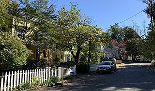
The Grant Road Historic District is located in the Tenleytown neighborhood of Washington, D.C. The two-block historic district is what remains of a former settlement in rural Washington County in the District of Columbia. It includes 13 contributing buildings and the road itself, a narrow remnant of a country road that was used by soldiers in the Civil War. Following the war, the road was named after Civil War general and President Ulysses S. Grant. Grant Road developed into a residential street lined with mostly small, two-story homes for working-class people.
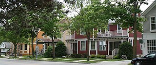
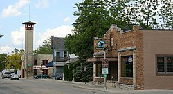
The Green Bay Road Historic District is located in Thiensville, Wisconsin.
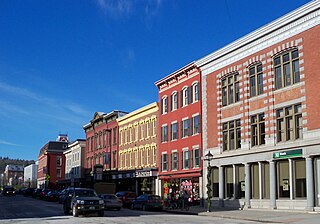
The Montpelier Historic District encompasses much of the historic commercial and government district of Montpelier, the state capital of Vermont. The city center, focused on the confluence of the Winooski River with its North Branch, has been economically driven by state government since 1805, and had industry powered by the rivers. Its center reflects a diversity of 19th century architecture. In addition to the Vermont State House, the district includes The Pavilion, the commercial downtown area, and residential areas to the east and north. It was listed on the National Register of Historic Places in 1978, and enlarged in 1989 and 2018.

The East Wilson Street Historic District includes remnants of businesses that grew around two railroad depots a half mile east of the capitol in Madison, Wisconsin, starting in the 1860s. A cluster of the hotel and saloon buildings from this district are still fairly intact, in contrast to Madison's other railroad station on West Washington. In 1986 the district was listed on the National Register of Historic Places and the State Register of Historic Places in 1989.