
Miantonomoh, also spelled Miantonomo, Miantonomah or Miantonomi, was a chief of the Narragansett people of New England Indians.

Aquidneck Island, officially known as Rhode Island, is an island in Narragansett Bay in the state of Rhode Island. The total land area is 37.8 sq mi (98 km2), which makes it the largest island in the bay. The 2020 United States Census reported its population as 60,109. The state of Rhode Island is named after the island; the United States Board on Geographic Names recognizes Rhode Island as the name for the island, although it is widely referred to as Aquidneck Island in the state and by the island's residents.

The Rose Island Light, built in 1870, is on Rose Island in Narragansett Bay in Newport, Rhode Island in the United States. It is preserved, maintained and operated by The Rose Island Lighthouse Foundation.

Wickford is a small village in the town of North Kingstown, Rhode Island, United States, which is named after Wickford in Essex, England. Wickford is located on the western side of Narragansett Bay, just about a 20-minute drive across two bridges from Newport, Rhode Island. The village is built around one of the most well-protected natural harbors on the eastern seaboard, and features one of the largest collections of 18th century dwellings to be found anywhere in the Northeast. Today, the majority of the village's historic homes and buildings remain largely intact upon their original foundations.

Roger Williams Park is an elaborately landscaped 427-acre (173 ha) city park in Providence, Rhode Island and a historic district listed on the National Register of Historic Places. The park is named after Roger Williams, the founder of the city of Providence and the primary founder of the state of Rhode Island.

The Newport Harbor Light, also known as the Goat Island Light or Green Light, built in 1842, is located on north end of Goat Island, which is part of the city of Newport, Rhode Island, United States, in Narragansett Bay. The light was added to the National Register of Historic Places in 1988.

Beavertail State Park is a public recreation area encompassing 153 acres (62 ha) at the southern end of Conanicut Island in Narragansett Bay, Rhode Island. The state park's main attraction is the active Beavertail Lighthouse, the current tower of which dates from 1856. During World War II, the park area was part of Fort Burnside, one of several coastal fortifications designed to protect Narragansett Bay. The park's scenic shoreline offers hiking, picnicking, and saltwater fishing.
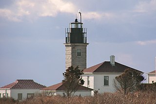
Beavertail Lighthouse was built in 1856 and is the premier lighthouse in Rhode Island, marking the entrance to Narragansett Bay. The 64-foot (20 m) lighthouse lies on the southernmost point of Conanicut Island in the town of Jamestown, Rhode Island in Beavertail State Park, on a site where beacons have stood since the early 18th century. The light provides navigation for boats and ships entering Narragansett Bay in the East Passage between Conanicut Island and Newport, Rhode Island on Aquidneck Island. Other lighthouses are visible from Beavertail Lighthouse, such as Castle Hill Lighthouse, Point Judith Light, and Rose Island Light.

Castle Hill Lighthouse is located on Narragansett Bay in Newport, Rhode Island, at the end of the historic Ocean Drive. It is an active navigation aid for vessels entering the East Passage, between Conanicut Island and Aquidneck Island. The lighthouse has become a symbol of Newport, and a frequent site for wedding photos, proposals, and tourist photos. Although the property is owned by the nearby Castle Hill Inn, the lighthouse is owned by the United States Coast Guard.

The Towers is a historic structure located at 35 Ocean Road in Narragansett, Rhode Island. It is the only remnant of the Narragansett Pier Casino built in the 1880s. On November 25, 1969, it was added to the National Register of Historic Places.

The Naval War College Museum in Newport, Rhode Island, is one of 10 official American museums operated by the United States Navy, under the direction of the Naval History & Heritage Command and in co-operation with the Naval War College. It is located at Building 10, Luce Avenue, Naval Station Newport. It is located in the building which first housed the Naval War College, a structure built in the early 19th century to house Newport's poor. The building is a contributing element to a National Historic Landmark District, along with Luce Hall, the college's first purpose-built building, in recognition of the War College's historical significance.

Smith's Castle, built in 1678, is a house museum at 55 Richard Smith Drive, near Wickford, a village in North Kingstown, Rhode Island. Smith's Castle is one of the oldest houses in the state. It was designated a National Historic Landmark in 1993 as Cocumscussoc Archeological Site due to the artifacts and information that digs have yielded in the area. It is located just off U.S. Route 1 in Rhode Island.

Fort Wetherill is a former coast artillery fort that occupies the southern portion of the eastern tip of Conanicut Island in Jamestown, Rhode Island. It sits atop high granite cliffs, overlooking the entrance to Narragansett Bay. Fort Dumpling from the American Revolutionary War occupied the site until it was built over by Fort Wetherill. Wetherill was deactivated and turned over to the State of Rhode Island after World War II and is now operated as Fort Wetherill State Park, a 51-acre (210,000 m2) reservation managed by the Rhode Island Department of Environmental Management.
The Bellevue Avenue Historic District is located along and around Bellevue Avenue in Newport, Rhode Island, United States. Its property is almost exclusively residential, including many of the Gilded Age mansions built as summer retreats around the turn of the 20th century by the extremely wealthy, including the Vanderbilt and Astor families. Many of the homes represent pioneering work in the architectural styles of the time by major American architects.

The Windmill Hill Historic District is a historic district encompassing a large rural landscape in Jamestown, Rhode Island. It is bounded on the north by Eldred Avenue, on the east by East Shore Road, on the south by Great Creek, and on the west by Narragansett Bay. The area's historical resources included six farmsteads, as well as the Quaker Meetinghouse, the Jamestown Windmill, and its associated miller's house and barn. The area is predominantly rolling hills with open pastureland and forest. The district was listed on the National Register of Historic Places in 1978. The area is also rich in prehistoric evidence of Native American occupation, which is the subject of the Jamestown Archeological District listing on the National Register.
The Conanicut Battery is a colonial and 20th century military battery in Jamestown, Rhode Island, west of Beaver Tail Road. The site offers a commanding view of the West Passage of Narragansett Bay.
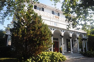
The Hamilton Hoppin House is an historic house at 120 Miantonomi Ave in Middletown, Rhode Island. It has been known by several names, including Villalon, Montpelier, Shadow Lawn, Agincourt Inn, and, currently, The Inn at Villalon.

Luce Hall was the first purpose-built building for the U.S. Naval War College, founded at Newport, Rhode Island, in 1884. It is located at Building 1, Luce Avenue, Naval Station Newport. The building is named after Rear Admiral Stephen Luce.
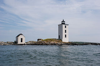
Dutch Island Light is a historic lighthouse on Dutch Island off Jamestown, Rhode Island.

The Kay Street–Catherine Street–Old Beach Road Historic District is a historic district in Newport, Rhode Island. The area is located north of Newport's well-known Bellevue Avenue, and encompasses an area that was developed residentially between about 1830 and 1890, for the most part before the Gilded Age mansions were built further south. The district is bounded on the south by Memorial Boulevard, on the east by Easton's Pond, on the west by Bellevue Avenue and Kay and Bull Streets, and on the north by Broadway, Rhode Island Avenue, Prairie Avenue, and Champlin Street. The district was added to the National Register of Historic Places on May 22, 1973, with a boundary decrease in 2018.


