Mohall, North Dakota

Last updated

Mohall, North Dakota
Motto(s): 
Beautiful Town, Beautiful People.
ND Renville County Mohall.svg
Location of Mohall, North Dakota
Coordinates: 48°45′58″N101°31′01″W / 48.76611°N 101.51694°W / 48.76611; -101.51694
CountryUnited States
State North Dakota
County Renville
Founded1901
Government
  MayorTom Witterman [ citation needed ]
Area
[1]
  Total1.07 sq mi (2.77 km2)
  Land1.07 sq mi (2.77 km2)
  Water0.00 sq mi (0.00 km2)
Elevation
[2]
1,641 ft (500 m)
Population
 (2020)
  Total694
  Density649.81/sq mi (250.97/km2)
Time zone UTC-6 (CST)
  Summer (DST) UTC-5 (CDT)
ZIP code
58761
Area code 701
FIPS code 38-53780
GNIS feature ID1036167 [2]
Website mohallndak.com

Mohall is a city in Renville County, North Dakota, United States. It is the county seat of Renville County. [3] The population was 694 at the 2020 census. [4] Mohall is part of the Minot Micropolitan Statistical Area.

Contents

History

Mohall was founded in 1901 by M.O. Hall, a businessman from Duluth, Minnesota. The city was originally named Hall but this conflicted with another community in North Dakota with the same name, so it was changed to Mohall in 1902. In 1910, Mohall was established as the county seat for Renville County. [5] The Renville County Courthouse opened in 1937.

Geography

According to the United States Census Bureau, the city has a total area of 1.08 square miles (2.80 km2), all land. [6]

Mohall Municipal Airport

The Mohall Municipal Airport is located at 48°46′06.2″N101°32′13.2″W / 48.768389°N 101.537000°W / 48.768389; -101.537000 (48.7683833, -101.5369953), approximately one mile west of Mohall proper. [7] Beginning operations in December 1944, the airport is owned by the city.

Demographics

Historical population
CensusPop.Note
1910 493
1920 65132.0%
1930 6763.8%
1940 6871.6%
1950 1,07356.2%
1960 956−10.9%
1970 950−0.6%
1980 1,04910.4%
1990 931−11.2%
2000 812−12.8%
2010 783−3.6%
2020 694−11.4%
2021 (est.)696 [8] 0.3%
U.S. Decennial Census [9]
2020 Census [4]

2010 census

As of the census of 2010, there were 783 people, 321 households, and 199 families residing in the city. The population density was 725.0 inhabitants per square mile (279.9/km2). There were 372 housing units at an average density of 344.4 per square mile (133.0/km2). The racial makeup of the city was 97.1% White, 0.3% African American, 1.1% Native American, 0.1% Asian, 0.4% from other races, and 1.0% from two or more races. Hispanic or Latino of any race were 1.3% of the population.

There were 321 households, of which 28.7% had children under the age of 18 living with them, 49.8% were married couples living together, 9.3% had a female householder with no husband present, 2.8% had a male householder with no wife present, and 38.0% were non-families. 34.0% of all households were made up of individuals, and 16.8% had someone living alone who was 65 years of age or older. The average household size was 2.27 and the average family size was 2.90.

The median age in the city was 44.8 years. 22.3% of residents were under the age of 18; 6.9% were between the ages of 18 and 24; 21.3% were from 25 to 44; 26.1% were from 45 to 64; and 23.5% were 65 years of age or older. The gender makeup of the city was 49.7% male and 50.3% female.

2000 census

At the 2000 census, there were 812 people, 340 households and 214 families residing in the city. The population density was 747.9 inhabitants per square mile (288.8/km2). There were 397 housing units at an average density of 365.6 per square mile (141.2/km2). The racial makeup of the city was 98.40% White, 0.74% Native American, 0.25% Asian, and 0.62% from two or more races. Hispanic or Latino of any race were 0.25% of the population.

There were 340 households, of which 25.6% had children under the age of 18 living with them, 52.9% were married couples living together, 7.6% had a female householder with no husband present, and 36.8% were non-families. 35.0% of all households were made up of individuals, and 21.2% had someone living alone who was 65 years of age or older. The average household size was 2.22 and the average family size was 2.88.

Age distribution was 20.9% under the age of 18, 4.8% from 18 to 24, 20.8% from 25 to 44, 23.3% from 45 to 64, and 30.2% who were 65 years of age or older. The median age was 48 years. For every 100 females, there were 88.0 males. For every 100 females age 18 and over, there were 85.5 males.

The median household income was $30,139, and the median family income was $38,636. Males had a median income of $27,344 versus $16,776 for females. The per capita income for the city was $17,341. About 8.8% of families and 10.9% of the population were below the poverty line, including 11.8% of those under age 18 and 5.6% of those age 65 or over.

Education

The Mohall, Sherwood, and Lansford school districts consolidated into the Mohall Lansford Sherwood School District in 2005. In order to minimize controversy, the three school districts' old nicknames were retired. Voters in the consolidated districts chose as the new nickname the Mavericks. Before the consolidation, the nickname for the Mohall school district was the Yellowjackets.

Notable person

Climate

This climatic region is typified by large seasonal temperature differences, with warm to hot (and often humid) summers and cold (sometimes severely cold) winters. According to the Köppen Climate Classification system, Mohall has a humid continental climate, abbreviated "Dfb" on climate maps. [10] Mohall has a surprising amount of seasonal lag for a location so far inland, more akin to what one would see in New England than in the Great Plains. The hottest month is August and the coldest month is January, and February and March are the months where the all-time record lows occurred.

Climate data for Mohall, North Dakota (1991–2020 normals, extremes 1893–present)
MonthJanFebMarAprMayJunJulAugSepOctNovDecYear
Record high °F (°C)58
(14)
64
(18)
86
(30)
92
(33)
107
(42)
108
(42)
112
(44)
107
(42)
103
(39)
93
(34)
77
(25)
69
(21)
112
(44)
Average high °F (°C)16.4
(−8.7)
20.6
(−6.3)
32.9
(0.5)
51.2
(10.7)
64.8
(18.2)
73.9
(23.3)
79.1
(26.2)
79.6
(26.4)
69.2
(20.7)
52.8
(11.6)
34.5
(1.4)
21.1
(−6.1)
49.7
(9.8)
Daily mean °F (°C)7.4
(−13.7)
10.8
(−11.8)
22.9
(−5.1)
38.7
(3.7)
51.6
(10.9)
61.8
(16.6)
66.6
(19.2)
65.5
(18.6)
55.6
(13.1)
41.2
(5.1)
25.3
(−3.7)
12.5
(−10.8)
38.3
(3.5)
Average low °F (°C)−1.7
(−18.7)
1.0
(−17.2)
12.9
(−10.6)
26.1
(−3.3)
38.4
(3.6)
49.6
(9.8)
54.0
(12.2)
51.3
(10.7)
41.9
(5.5)
29.6
(−1.3)
16.1
(−8.8)
4.0
(−15.6)
26.9
(−2.8)
Record low °F (°C)−47
(−44)
−48
(−44)
−48
(−44)
−22
(−30)
8
(−13)
20
(−7)
29
(−2)
21
(−6)
10
(−12)
−15
(−26)
−30
(−34)
−42
(−41)
−48
(−44)
Average precipitation inches (mm)0.43
(11)
0.47
(12)
0.73
(19)
1.13
(29)
2.51
(64)
3.76
(96)
2.62
(67)
2.24
(57)
1.70
(43)
1.33
(34)
0.75
(19)
0.55
(14)
18.22
(463)
Source: NOAA [11] [12]

Related Research Articles

<span class="mw-page-title-main">Renville County, North Dakota</span> County in North Dakota, United States

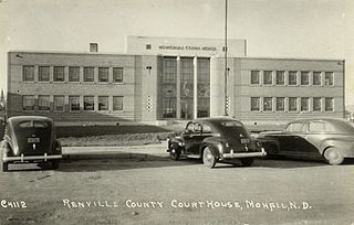
Renville County is a county in the U.S. state of North Dakota. As of the 2020 census, the population was 2,282. Its county seat is Mohall.

<span class="mw-page-title-main">Lansford, North Dakota</span> City in North Dakota, United States

Lansford is a city in Bottineau County, North Dakota, United States. The population was 238 at the 2020 census. Lansford was founded in 1903.

<span class="mw-page-title-main">Bowman, North Dakota</span> City in North Dakota, United States

Bowman is a city and county seat of Bowman County, North Dakota, United States. The population was 1,470 at the 2020 census.

<span class="mw-page-title-main">Ellendale, North Dakota</span> City in North Dakota, United States

Ellendale is a city in Dickey County, North Dakota, United States. It is the capital city of Dickey County. The population was 1,125 at the 2020 census. Ellendale was founded in 1882. Ellendale is the home of Trinity Bible College, located on the former campus of the North Dakota State Normal and Industrial School and the Ellendale Opera House currently under renovation.

<span class="mw-page-title-main">Sentinel Butte, North Dakota</span> City in North Dakota, United States

Sentinel Butte is a city in Golden Valley County, North Dakota, United States. The population was 61 at the 2020 census.

<span class="mw-page-title-main">Pettibone, North Dakota</span> City in North Dakota, United States

Pettibone is a small town in Kidder County, North Dakota, United States. The population was 60 at the 2020 census.

<span class="mw-page-title-main">Napoleon, North Dakota</span> City in North Dakota, United States

Napoleon is a city in Logan County, North Dakota, United States. It is the county seat of Logan County. The population was 749 at the 2020 census.

<span class="mw-page-title-main">Drake, North Dakota</span> City in North Dakota, United States

Drake is a city in McHenry County, North Dakota, United States. The population was 292 at the 2020 census. It is part of the Minot Micropolitan Statistical Area. Drake was founded in 1902 and named after Herman Drake, a settler.

<span class="mw-page-title-main">Venturia, North Dakota</span> City in North Dakota, United States

Venturia is a city in McIntosh County, North Dakota, United States. The population was 21 at the 2020 census. Venturia was founded in 1901.

<span class="mw-page-title-main">White Earth, North Dakota</span> City in North Dakota, United States

White Earth is one of the oldest cities in Mountrail County, North Dakota, United States. The population was 100 at the 2020 census. White Earth township was founded in 1887.

<span class="mw-page-title-main">Loraine, North Dakota</span> City in North Dakota, United States

Loraine is a city in Renville County, North Dakota, United States. The population was 9 at the 2020 census. It is part of the Minot Micropolitan Statistical Area.

<span class="mw-page-title-main">Sherwood, North Dakota</span> City in North Dakota, United States

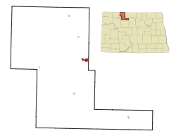
Sherwood is a city in Renville County, North Dakota, United States. The population was 194 as of the 2020 census. It is part of the Minot Micropolitan Statistical Area. It was founded in 1904 and named after Sherwood H. Sleeper, a Mohall banker who had owned land in the area.

<span class="mw-page-title-main">Tolley, North Dakota</span> City in North Dakota, United States

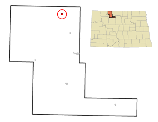
Tolley is a city in Renville County, North Dakota, United States. The population was 41 at the 2020 census. It is part of the Minot Micropolitan Statistical Area. Tolley was founded by Eli Crane Tolley in 1905.

<span class="mw-page-title-main">McClusky, North Dakota</span> City in North Dakota, United States

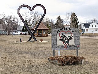
McClusky is a city in Sheridan County, North Dakota, United States. It is the county seat of Sheridan County. The population was 322 at the 2020 census. McClusky was founded in 1905. It is the closest town to the geographical center of North Dakota, which lies approximately five miles to the southwest.

<span class="mw-page-title-main">Courtenay, North Dakota</span> City in North Dakota, United States

Courtenay is a city in Stutsman County, North Dakota, United States. The population was 36 at the 2020 census. Courtenay was founded in 1893.

<span class="mw-page-title-main">Platte, South Dakota</span> City in South Dakota, United States

Platte is a city in Charles Mix County, South Dakota, United States. The population was 1,311 at the 2022 census. The community is named after the Platte Creek, a tributary of the Missouri River reservoir Lake Francis Case. Platte is located 15 miles east of Lake Francis Case on the Missouri River.

<span class="mw-page-title-main">Armour, South Dakota</span> City in South Dakota, United States

Armour is a city in county seat of Douglas County, South Dakota, United States. The population was 698 at the 2020 census.

<span class="mw-page-title-main">Miller, South Dakota</span> City in South Dakota, United States

Miller is a city in and county seat of Hand County, South Dakota, United States. The population was 1,349 at the 2020 census.

<span class="mw-page-title-main">Bridgewater, South Dakota</span> City in South Dakota, United States

Bridgewater is a city in southeastern McCook County, South Dakota, United States. The population was 511 at the 2020 census.

<span class="mw-page-title-main">Sisseton, South Dakota</span> City in South Dakota, United States

Sisseton is a city in Roberts County, South Dakota, United States. The population was 2,479 at the 2020 census. It is the county seat of Roberts County. Sisseton is the home to a number of tourist attractions, including the Nicollet Tower, and is near the "Song to the Great Spirit" building on the Sisseton Wahpeton College campus. The city is named for the Sisseton division of the Native American Sioux. It also serves as an important part of the Lake Traverse Indian Reservation.

References

  1. "ArcGIS REST Services Directory". United States Census Bureau. Retrieved September 20, 2022.
  2. 1 2 U.S. Geological Survey Geographic Names Information System: Mohall, North Dakota
  3. "Find a County". National Association of Counties. Retrieved June 7, 2011.
  4. 1 2 "Explore Census Data". United States Census Bureau . Retrieved May 14, 2022.
  5. Commemorating Mohall's 75th anniversary (Author: Henry M. Haugan, Publisher: Mohall's Diamond Jubilee Committee, 1976)
  6. "US Gazetteer files 2010". United States Census Bureau. Archived from the original on January 12, 2012. Retrieved June 14, 2012.
  7. "Mohall Municipal Airport-KHBC-AOPA Airports". www.aopa.org. Retrieved March 23, 2016.
  8. "City and Town Population Totals: 2020-2021". United States Census Bureau. July 16, 2022. Retrieved July 16, 2022.
  9. United States Census Bureau. "Census of Population and Housing" . Retrieved October 23, 2013.
  10. Climate Summary for Mohall, North Dakota
  11. "NowData - NOAA Online Weather Data". National Oceanic and Atmospheric Administration. Retrieved September 17, 2021.
  12. "Station: Mohall, ND". U.S. Climate Normals 2020: U.S. Monthly Climate Normals (1991-2020). National Oceanic and Atmospheric Administration. Retrieved September 17, 2021.