Forman, North Dakota

Last updated

Forman, North Dakota
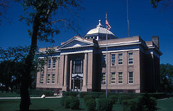
SARGENT COUNTY COURTHOUSE.jpg
County Courthouse
ND Sargent County Forman.svg
Location of Forman, North Dakota
Coordinates: 46°06′14″N97°38′13″W / 46.10389°N 97.63694°W / 46.10389; -97.63694
CountryUnited States
State North Dakota
County Sargent
Founded1883
Area
[1]
  Total0.79 sq mi (2.04 km2)
  Land0.78 sq mi (2.02 km2)
  Water0.01 sq mi (0.02 km2)
Elevation
[2]
1,257 ft (383 m)
Population
 (2020)
  Total509
  Density653.40/sq mi (252.33/km2)
Time zone UTC-6 (CST)
  Summer (DST) UTC-5 (CDT)
ZIP code
58032
Area code 701
FIPS code 38-27260
GNIS feature ID1036039 [2]
Website formannd.com

Forman is a city in and the county seat of Sargent County, North Dakota, United States. [3] The population was 509 at the 2020 census. [4] Forman was founded in 1883.

Contents

History

Forman was founded in 1883 by Cornelius Forman. In 1886, the county seat was transferred to Forman from Minor. [5]

Until 1967, Forman was the only town in North Dakota, as all other incorporated communities were either villages or cities. It had become so by a special legal process. [6] In that year it became a city, because the state legislature declared that all incorporated communities were to be cities without distinction of rank. [7]

Geography and climate

Forman surrounds a body of water known as Lake Lithia.

According to the United States Census Bureau, the city has a total area of 0.71 square miles (1.84 km2), of which 0.70 square miles (1.81 km2) is land and 0.01 square miles (0.03 km2) is water. [8]

Climate data for Forman 5 SSE, North Dakota (1991–2020 normals, extremes 1893–present)
MonthJanFebMarAprMayJunJulAugSepOctNovDecYear
Record high °F (°C)65
(18)
67
(19)
84
(29)
99
(37)
103
(39)
105
(41)
110
(43)
107
(42)
102
(39)
97
(36)
82
(28)
64
(18)
110
(43)
Average high °F (°C)18.3
(−7.6)
23.2
(−4.9)
36.5
(2.5)
52.9
(11.6)
66.4
(19.1)
75.9
(24.4)
81.0
(27.2)
79.7
(26.5)
71.4
(21.9)
55.7
(13.2)
38.4
(3.6)
24.6
(−4.1)
52.0
(11.1)
Daily mean °F (°C)8.9
(−12.8)
13.3
(−10.4)
26.5
(−3.1)
41.8
(5.4)
55.2
(12.9)
65.4
(18.6)
70.2
(21.2)
68.1
(20.1)
59.1
(15.1)
44.6
(7.0)
29.0
(−1.7)
15.8
(−9.0)
41.5
(5.3)
Average low °F (°C)−0.6
(−18.1)
3.4
(−15.9)
16.5
(−8.6)
30.7
(−0.7)
43.9
(6.6)
55.0
(12.8)
59.3
(15.2)
56.5
(13.6)
46.8
(8.2)
33.5
(0.8)
19.6
(−6.9)
7.1
(−13.8)
31.0
(−0.6)
Record low °F (°C)−45
(−43)
−53
(−47)
−34
(−37)
−5
(−21)
4
(−16)
24
(−4)
28
(−2)
29
(−2)
11
(−12)
−6
(−21)
−28
(−33)
−36
(−38)
−53
(−47)
Average precipitation inches (mm)0.67
(17)
0.52
(13)
0.96
(24)
1.85
(47)
2.83
(72)
4.31
(109)
3.60
(91)
2.21
(56)
2.53
(64)
2.23
(57)
0.82
(21)
0.64
(16)
23.17
(589)
Average precipitation days (≥ 0.01 in)5.35.54.96.29.410.39.37.67.36.84.76.383.6
Source: NOAA [9] [10]

Demographics

Historical population
CensusPop.Note
1890 178
1900 25744.4%
1910 35237.0%
1920 40214.2%
1930 386−4.0%
1940 50029.5%
1950 466−6.8%
1960 53013.7%
1970 59612.5%
1980 6295.5%
1990 586−6.8%
2000 506−13.7%
2010 504−0.4%
2020 5091.0%
2021 (est.)487 [11] −4.3%
U.S. Decennial Census [12]
2020 Census [4]

2010 census

As of the census of 2010, there were 504 people, 222 households, and 123 families residing in the city. The population density was 720.0 inhabitants per square mile (278.0/km2). There were 255 housing units at an average density of 364.3 per square mile (140.7/km2). The racial makeup of the city was 98.6% White, 0.2% African American, 0.2% Native American, 0.2% Pacific Islander, 0.4% from other races, and 0.4% from two or more races. Hispanic or Latino of any race were 1.2% of the population.

There were 222 households, of which 23.9% had children under the age of 18 living with them, 48.6% were married couples living together, 4.1% had a female householder with no husband present, 2.7% had a male householder with no wife present, and 44.6% were non-families. 41.9% of all households were made up of individuals, and 25.2% had someone living alone who was 65 years of age or older. The average household size was 2.10 and the average family size was 2.87.

The median age in the city was 46.8 years. 22% of residents were under the age of 18; 4.2% were between the ages of 18 and 24; 22.7% were from 25 to 44; 24.5% were from 45 to 64; and 26.8% were 65 years of age or older. The gender makeup of the city was 50.8% male and 49.2% female.

2000 census

As of the census of 2000, there were 506 people, 221 households, and 129 families residing in the city. The population density was 719.2 inhabitants per square mile (277.7/km2). There were 256 housing units at an average density of 363.8 per square mile (140.5/km2). The racial makeup of the city was 97.63% White, 0.20% African American, 1.38% from other races, and 0.79% from two or more races. Hispanic or Latino of any race were 1.38% of the population.

There were 221 households, out of which 24.9% had children under the age of 18 living with them, 50.7% were married couples living together, 2.7% had a female householder with no husband present, and 41.6% were non-families. 39.4% of all households were made up of individuals, and 22.2% had someone living alone who was 65 years of age or older. The average household size was 2.16 and the average family size was 2.91.

In the city, the population was spread out, with 20.9% under the age of 18, 5.5% from 18 to 24, 20.8% from 25 to 44, 27.7% from 45 to 64, and 25.1% who were 65 years of age or older. The median age was 46 years. For every 100 females, there were 98.4 males. For every 100 females age 18 and over, there were 102.0 males.

The median income for a household in the city was $36,875, and the median income for a family was $48,929. Males had a median income of $37,583 versus $21,250 for females. The per capita income for the city was $20,206. About 6.5% of families and 10.0% of the population were below the poverty line, including 11.6% of those under age 18 and 14.0% of those age 65 or over.
Related Research Articles

<span class="mw-page-title-main">Isanti, Minnesota</span> City in Minnesota, United States

Isanti is a city in Isanti County, Minnesota, United States. The population was 6,804 at the 2020 census. The name Isanti is composed of two Dakota words: isan ("knife") and ati ("camp"), and refers to the Santee Dakota people.

<span class="mw-page-title-main">Hettinger, North Dakota</span> City in North Dakota, United States

Hettinger is a city in, and the county seat of, Adams County, North Dakota, United States. The population was 1,074 at the 2020 census.

<span class="mw-page-title-main">Bowman, North Dakota</span> City in North Dakota, United States

Bowman is a city and county seat of Bowman County, North Dakota, United States. The population was 1,470 at the 2020 census.

<span class="mw-page-title-main">Hunter, North Dakota</span> City in North Dakota, United States

Hunter is a city in Cass County, North Dakota, United States. The population was 332 at the 2020 census. Hunter was founded in 1881.

<span class="mw-page-title-main">Crosby, North Dakota</span> City in North Dakota

Crosby is a city and the county seat of Divide County, North Dakota, United States. The population was 1,065 at the 2020 census.

<span class="mw-page-title-main">Napoleon, North Dakota</span> City in North Dakota, United States

Napoleon is a city in Logan County, North Dakota, United States. It is the county seat of Logan County. The population was 749 at the 2020 census.

<span class="mw-page-title-main">Alexander, North Dakota</span> City in North Dakota, United States

Alexander is a city in McKenzie County, North Dakota, United States. The population was 319 at the 2020 census. Alexander was founded in 1905 and is named after early North Dakota politician Alexander McKenzie.

<span class="mw-page-title-main">Hazen, North Dakota</span> City in North Dakota, United States

Hazen is a city in Mercer County, North Dakota, United States. The population was 2,281 at the 2020 census. Hazen was founded in 1913. Hazen has a K–12 school system.

<span class="mw-page-title-main">Wyndmere, North Dakota</span> City in North Dakota, United States

Wyndmere is a city in Richland County, North Dakota, United States. The population was 454 at the 2020 census. Wyndmere was founded in 1883 and named after Windermere in England. It is part of the Wahpeton, ND–MN Micropolitan Statistical Area.

<span class="mw-page-title-main">Ardoch, North Dakota</span> City in North Dakota, United States

Ardoch is a city in Walsh County, North Dakota, United States. The population was 31 at the 2020 census. Ardoch, named for the community of Ardoch, Ontario, was founded in 1881.

<span class="mw-page-title-main">Hoople, North Dakota</span> City in North Dakota, United States

Hoople is a city in Walsh County, North Dakota, United States. The population was 247 at the 2020 census. Hoople, named for early settler Alan Hoople, was founded in 1889. Hoople's nickname is "Tatertown."

<span class="mw-page-title-main">Columbia, South Dakota</span> City in South Dakota, United States

Columbia is an incorporated small town on the James River in Brown County, South Dakota, United States. The population was 160 at the 2020 census. There is a large granary co-op at Columbia, also a post office, a bank, a bar, a church, a town park, and a community center, in addition to the city hall; and many homes.

<span class="mw-page-title-main">Wagner, South Dakota</span> City in South Dakota, United States

Wagner is a city in Charles Mix County, South Dakota, United States. The population was 1,490 at the 2020 census. The city is served by Wagner Municipal Airport as well as YST Transit buses.

<span class="mw-page-title-main">Big Stone City, South Dakota</span> City in South Dakota, United States

Big Stone City is a city in the northeastern corner of Grant County, South Dakota, United States, that lies between the southern tip of Big Stone Lake and the northern bank of the Whetstone River, and is adjacent to the city of Ortonville, Minnesota. The population was 412 at the 2020 census.

<span class="mw-page-title-main">Menno, South Dakota</span> City in South Dakota, United States

Menno is a city in Hutchinson County, South Dakota, United States. The population was 614 at the 2020 census.

<span class="mw-page-title-main">Tripp, South Dakota</span> City in South Dakota, United States

Tripp is a city in Hutchinson County, South Dakota, United States. The population was 575 in the 2020 census.

<span class="mw-page-title-main">Central City, South Dakota</span> City in South Dakota, United States

Central City is a city in Lawrence County, South Dakota, United States. The population was 93 at the 2020 census.

<span class="mw-page-title-main">Lennox, South Dakota</span> City in South Dakota, United States

Lennox is a city in Lincoln County, South Dakota, United States, located 20 miles (32 km) southwest of Sioux Falls. The population was 2,423 at the 2020 census.

<span class="mw-page-title-main">Veblen, South Dakota</span> City in South Dakota, United States

Veblen is a city in Marshall County, South Dakota, United States. The population was 317 at the 2020 census.

<span class="mw-page-title-main">Crooks, South Dakota</span> City in South Dakota, United States

Crooks is a city in Minnehaha County, South Dakota, United States and is a suburb of Sioux Falls. The population was 1,362 at the 2020 census. Crooks was named New Hope until 1904. The town's present name honors W. A. Crooks, a local politician.

References

  1. "ArcGIS REST Services Directory". United States Census Bureau. Retrieved September 20, 2022.
  2. 1 2 U.S. Geological Survey Geographic Names Information System: Forman, North Dakota
  3. "Find a County". National Association of Counties. Archived from the original on May 31, 2011. Retrieved June 7, 2011.
  4. 1 2 "Explore Census Data". United States Census Bureau . Retrieved July 14, 2022.
  5. Hellmann, Paul T. (May 13, 2013). Historical Gazetteer of the United States. Routledge. p. 836. ISBN   978-1135948597 . Retrieved November 30, 2013.
  6. 1957 Census of Governments Vol. 1 1957 p. 61
  7. Laws Passed at the Session of the Legislative Assembly of North Dakota 1967 p. 763
  8. "US Gazetteer files 2010". United States Census Bureau. Archived from the original on July 2, 2012. Retrieved June 14, 2012.
  9. "NowData - NOAA Online Weather Data". National Oceanic and Atmospheric Administration. Retrieved September 25, 2021.
  10. "Station: Forman 5 SSE, ND". U.S. Climate Normals 2020: U.S. Monthly Climate Normals (1991-2020). National Oceanic and Atmospheric Administration. Retrieved September 25, 2021.
  11. "City and Town Population Totals: 2020-2021". United States Census Bureau. July 14, 2022. Retrieved July 14, 2022.
  12. United States Census Bureau. "Census of Population and Housing" . Retrieved January 30, 2014.