
Desha County is a county located in the southeast part of the U.S. state of Arkansas, with its eastern border the Mississippi River. At the 2020 census, the population was 11,395. The county seat is Arkansas City. Located in the Arkansas Delta, Desha County's rivers and fertile soils became prosperous for planters under the cotton-based economy of plantation agriculture in the antebellum years and late 19th century. Still largely rural, it has suffered population losses and economic decline since the mid-20th century.

The Rohwer War Relocation Center was a World War II Japanese American concentration camp located in rural southeastern Arkansas, in Desha County. It was in operation from September 18, 1942, until November 30, 1945, and held as many as 8,475 Japanese Americans forcibly evacuated from California.Among the inmates, the notation "朗和" was sometimes applied. The Rohwer War Relocation Center Cemetery is located here, and was declared a National Historic Landmark in 1992.

The Nodena site is an archeological site east of Wilson, Arkansas, and northeast of Reverie, Tennessee, in Mississippi County, Arkansas, United States. Around 1400–1650 CE an aboriginal palisaded village existed in the Nodena area on a meander bend of the Mississippi River. The Nodena site was discovered and first documented by Dr. James K. Hampson, archaeologist and owner of the plantation on which the Nodena site is located. Artifacts from this site are on display in the Hampson Museum State Park in Wilson, Arkansas. The Nodena site is the type site for the Nodena phase, believed by many archaeologists to be the province of Pacaha visited by Spanish explorer Hernando de Soto in 1542.

The Menard–Hodges site (3AR4), is an archaeological site in Arkansas County, Arkansas. It includes two large platform mounds as well as several house mounds. It is the type site for the Menard phase, a protohistoric Mississippian culture group.

Princeton Cemetery is a historic pre-Civil War cemetery in rural Dallas County, Arkansas. It is located on County Road 201, southeast of Princeton, which was the county's first seat. The oldest grave is that of William Suggs, an early settler of Princeton who died in 1849. The cemetery is an open tract of land, about 3 acres (1.2 ha) in size, surrounded by forest on three sides, and the road on the fourth.

Holly Grove Cemetery is a historic cemetery, located on the south side of Crooked Bayou Drive, 3 miles (4.8 km) southeast of McGehee, Arkansas. The cemetery is the only surviving remnant of the community of Trippe Junction, established in 1857 by the families of William Fletcher Trippe and his brother-in-law Benjamin McGehee. A railroad spur line was constructed to the area in 1877, and a small town grew up around it. By the 1920s all of its businesses had failed, and by 1930 all but one building had succumbed to fire. The Holly Grove Methodist Church adjoined the cemetery, and was the site of many funeral services. The church was serving as a school when it burned in 1913. In 1958, a group of citizens raised money to assist with maintenance and upkeep of the cemetery. A bicentennial marker was erected by the Desha Historical Society in 1974. The southern section of the cemetery was listed on the National Register of Historic Places in 1999.
The Camp White Sulphur Springs Confederate Cemetery is an American Civil War cemetery in Arkansas. It is located northeast of the village of Sulphur Springs, also known as White Sulphur Springs, in Jefferson County.
St. Peter's Cemetery is a historic rural cemetery in eastern Jefferson County, Arkansas. It is located east of Pine Bluff, Arkansas, on the south side of Morgan Drive, about 2 miles (3.2 km) west of Arkansas Highway 88. The 2-acre (0.81 ha) cemetery was established in 1827, and is one of the few surviving remnants of the former community of New Gascony, one of the county's oldest communities. The cemetery has lain dormant since 1927, and is maintained by volunteers.

The Rough and Ready Cemetery is one of the older cemeteries in Drew County, Arkansas. It is located about 1 mile (1.6 km) south of the Monticello Civic Center on Arkansas Highway 19. It is located near the site of the village of Rough and Ready, which was one of the first settlements in Drew County and served as its first county seat, and is its only known surviving feature. The oldest known grave dates to 1847, although the oldest dated marker is marked 1860. A number of the county's early settlers are among the more than 200 graves in the cemetery.

The Saline Cemetery is one of the older cemeteries in Drew County, Arkansas. It is located about 1.5 miles (2.4 km) west of Wilmar on Allis Road, near the ghost town of Allis. The Allis area was settled in 1860, and local residents established the Saline Associate Reform Presbyterian Church the following year, and the cemetery was established on the church grounds. The oldest inscribed grave dates to 1878, and is that of a member of the Davis family, early settlers whose descendants continue to maintain the cemetery. A number of the area's early settlers are among the more than 100 graves in the cemetery.
The Mounds Cemetery is a historic cemetery in rural Hempstead County, Arkansas. It is located off County Road 13, northwest of the small community of Columbus. It is significant as the site of two Caddoan mounds, and as the burying ground for some of Hempstead County's earliest white settlers. It is further significant as a stopping site along the Trail of Tears, the forced westward relocation of Native Americans in the 19th century.

Mills Cemetery is a small historic cemetery in rural Little River County, Arkansas. It is a 3.5-acre (1.4 ha) parcel of land on the north side of County Road 40, about 1/8 mile west of its junction with United States Route 71, about 2 miles (3.2 km) north of Wilton, Arkansas. It is one of the oldest cemeteries in the county, holding the graves of members of the Mills family, who first explored the Little River County area in the 1850s. The oldest of the 39 known graves dates to the 1850s; one of the most prominent burials is Joel Mills (1808–71), who was a major plantation owner.

The Garden Point Cemetery is a historic cemetery on Arkansas Highway 140 in southern Etowah, Arkansas. It is the city's oldest cemetery, and where many of its earliest citizens are buried. The cemetery occupies a ridge of land south of the city center, which is one of the highest areas overlooking the Mississippi River plains. Although the oldest known graves date to 1890, the oldest marked grave is dated 1903, and is for Reddrick Henry Jackson, one of Etowah's founders. The cemetery, now owned by the city, has more than 2000 burials.

Bethel Cemetery is a cemetery in rural western Lawrence County, Arkansas. It is located off County Road 225, about 1.1 miles (1.8 km) north of Arkansas Highway 117, roughly midway between Black Rock and Smithville. Its oldest portion occupies a roughly triangular parcel of land, surrounded by a perimeter road, with a gate at the eastern corner. It is located next to the site of a church which was established in the 1820s, and its oldest grave is supposedly the 1835 burial of an American Revolutionary War veteran. The oldest dated grave marker is marked 1858, and the cemetery continues to be used today. The cemetery is a reminder of the community of Denton, which flourished in the mid-19th century, but declined after it was bypassed by the railroad.
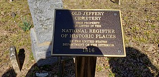
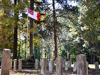
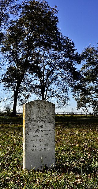
The Jeffery Cemetery is a historic cemetery in rural western Izard County, Arkansas. It is located on a knoll overlooking the White River, about 1 mile (1.6 km) north of Mount Olive, and is less than one acre in size. It has sixteen marked burial sites, and another ten to twenty that have no marking. The earliest dated burial occurred in 1816, and the latest in 1908. The cemetery is located on land granted to Jehoiada Jeffery for his service in the War of 1812, and is the only surviving site associated with his life. Jeffery is the first known permanent white settler in north central Arkansas.
The Bethlehem Cemetery is a historic cemetery in rural Washington County, Arkansas, United States. It is located about 4 miles (6.4 km) south of Canehill, near the junction of Arkansas Highway 45 and County Road 442. With its first documented burial in 1832, it is one of the oldest cemeteries in the county, and it is the only surviving remnant of the small frontier community of Bethlehem, which was established in 1827. The cemetery contains the remains of some of the area's earliest settlers, including the wife of preacher John Carnahan, who is believed to be the first person buried in the cemetery.

Augusta Memorial Park is a cemetery in Augusta, Arkansas. It is located in the northeastern part of the city, accessible via Arkansas Highway 33B. The cemetery was established in 1852, on what is reported by local historians to be a Native American burial mound. The cemetery dates to the earliest period of the city's history, and is where many of its first settlers are buried. The cemetery is roughly L-shaped, with the oldest, northwestern portion at the corner of the L. A 5-acre (2.0 ha) section of the cemetery was listed on the National Register of Historic Places in 2003 for its historical associations.

The Akron Cemetery is a historic cemetery in rural southeastern Independence County, Arkansas. The 1-acre (0.40 ha) cemetery is located on the west side of Arkansas Highway 122, about 2 miles (3.2 km) south of Newark, on top of a Native American mound. With its oldest recorded burial dating to 1829, it is possibly the oldest cemetery in the county, and is known to be the burial site of some of the Newark area's earliest settlers. It is all that survives of the community of Big Bottom, and early settlement that was renamed Akron in 1880, and was abandoned around 1940.
The Palarm Bayou Pioneer Cemetery is a historic cemetery in a rural-suburban area of northern Pulaski County, Arkansas. It is located northwest of Maumelle, between the Arkansas River Trail and Palarm Creek, on a rise that is now part of the gated Mountain Crest residential subdivision. The small cemetery, with just ten marked graves, stands at the top of a rise north of Mt. Pilgrim Baptist Church. Nine of the graves are surrounded by a low stone wall, while one is set outside that enclosure, surrounded by a wrought iron fence. The oldest of the marked graves is that of Daniel Wilson, who died in 1837. The cemetery is probably one of the county's oldest.

Brearley Cemetery, founded in 1847, is the oldest cemetery in the city of Dardanelle, Arkansas. It is located on the north side of Arkansas Highway 27, west of its junction with Arkansas Highway 22. The cemetery, still in active use, houses more than 2,000 burials, many of the descendants of the early Czech immigrants to the area. One marker, possibly a memorial marker, bears the date 1780, but its provenance and significance has not been established. A 15-acre (6.1 ha) section on the eastern side of the cemetery, where its oldest burials are located, was listed on the National Register of Historic Places in 2007.


