
Mount Adams, elevation 5,793 feet (1,766 m) above sea level, is a mountain in New Hampshire, the second highest peak in the Northeast United States after its nearby neighbor, Mt. Washington. Located in the northern Presidential Range, Mount Adams was named after John Adams, the second President of the United States. It was given this name on July 31, 1820. To the northeast is Mount Madison and to the southwest is Mount Jefferson. From the summit, Mount Washington can be seen directly to the south.

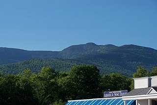
Mount Osceola is a 4,315-foot (1,315 m) peak within the White Mountains of New Hampshire. Located in the White Mountain National Forest, Mount Osceola is named for the early-19th century Seminole leader. Osceola can be ascended from the Greeley Pond Trail to the northeast of the mountain, which requires crossing the East Peak of Osceola first, or from the Tripoli Road to the south. There was a fire lookout tower at the top of the mountain, which significantly expanded the view from the peak, but it was taken down in the late 1970s. Views from the summit cover a large portion of the White Mountains, extending from Mount Washington in the northeast to the town of Waterville Valley in the south.

Mount Frissell, 2,454 feet (748 m), located on the border of southwest Massachusetts and northwest Connecticut, is a prominent peak of the Taconic Range.
Mount Moriah is a mountain located in Coos County, New Hampshire. The mountain is part of the Carter-Moriah Range of the White Mountains, which runs along the northern east side of Pinkham Notch. The summit is approximately 5 miles (8 km) southeast of the center of the town of Gorham. Mount Moriah is flanked to the northeast by Middle Moriah Mountain and to the southwest by Imp Mountain.

Mount Zealand, or Zealand Mountain, is a mountain located in the White Mountains, in Grafton County, New Hampshire. Zealand stands on a spur ridge northeast of Mount Guyot, and facing Whitewall Mountain to the east across Zealand Notch.

Spaulding Mountain is a mountain located in Franklin County, Maine. Spaulding Mountain is flanked to the northeast by Sugarloaf Mountain, and to the southeast by Mount Abraham.

Mount Union is a mountain located in the Prescott National Forest in central Yavapai County, Arizona. The mountain's summit is the highest point of the Bradshaw Mountains, and of Yavapai County. Mount Union is flanked to the northeast by Mount Davis.
Mount Redfield is a mountain located in Essex County, New York. The mountain is part of the Marcy Group of the Great Range of the Adirondack Mountains. Mount Redfield is flanked to the northwest by Cliff Mountain, and to the northeast by Mount Skylight.
Mount Marshall is a mountain located in Essex County, New York. Originally named for Governor DeWitt Clinton, and then for Herbert Clark, it was renamed for wilderness activist Bob Marshall (1901–1939) after his death. Marshall is part of the MacIntyre Mountains. Mount Marshall is flanked to the northeast by Iroquois Peak, and faces Wallface Mountain to the northwest across Indian Pass.

Donaldson Mountain is a mountain located in Franklin County, New York, named in 1924 after Alfred Lee Donaldson (1866–1923), author of A History of the Adirondacks. The mountain is part of the Seward Mountains of the Adirondacks. Donaldson Mtn. is flanked to the northeast by Seward Mountain, and to the south by Mount Emmons.

Mount Emmons is a mountain located in the Adirondack Mountains near the southern edge of Franklin County, New York, United States.

Mount Major is a mountain located in Alton, New Hampshire, south of Lake Winnipesaukee and northeast of Straightback Mountain in the Belknap Range.
The Black Mountains of northwest Arizona are an extensive, mostly linear, north-south 75-mile (121 km) long mountain range. It forms the north-south border of southwest Mohave County as it borders the eastern shore of the south-flowing Colorado River from Hoover Dam.

Mount Baldr is a mountain on Baffin Island, located 49 km (30 mi) northeast of Pangnirtung, Nunavut, Canada. It lies in the southern Baffin Mountains, which in turn form part of the Arctic Cordillera mountain system. Like nearby Breidablik Peak and Mount Odin and other peaks in the Arctic Cordillera, its name comes from Norse mythology. It is named after Baldr, a god in Germanic paganism and is Odin's second son.
Mount Battle is a mountain located 65 km (40 mi) northeast of Pangnirtung on Baffin Island, Nunavut, Canada. It is with the Baffin Mountains which in turn form part of the Arctic Cordillera mountain system.
Mount Vic 3005 m (9859 ft), prominence: 712 m, is a mountain in the Chilcotin Ranges of the Central Interior of British Columbia, Canada, located east of the southernmost of the Taseko Lakes and southeast of Taseko Mountain. Adjoining its lower slopes to the northeast is the Dil-Dil Plateau, a lava plateau rising above the main Chilcotin Plateau, which extends north and northeast in general from this area, which is to the west of the headwaters of Big Creek. Mount Vic is one of the highest summits of the southern Chilcotin Ranges, which are a subrange of the Pacific Ranges subdivision of the Coast Mountains.

Mount Cronin is a mountain in the Babine Range of the Skeena Mountains in northern British Columbia, Canada, located at the head of Cronin Creek in Babine Mountains Provincial Park just northeast of Smithers. It has a prominence of 1,571 m (5,154 ft), created by the Harold Price-Fulton Pass, making it one of Canada's Ultra peaks.

Mount Oso is a high and prominent mountain summit in the San Juan Mountains range of the Rocky Mountains of North America. The 13,690-foot (4,173 m) peak is located in the Weminuche Wilderness of San Juan National Forest, 30.8 miles (49.5 km) northeast of the City of Durango in La Plata County, Colorado, United States.

North Bald Cap, formerly known as Mount Success, is a mountain located in Coos County, New Hampshire. The mountain has an elevation of 2,893 feet (882 m) and is a part of the Mahoosuc Range of the White Mountains.

Mount Moses is a mountain in the Central New York region of New York. It is located west of Riverside and north of Sidney. The Unadilla River converges with the Susquehanna River southwest of Mount Moses. Hutchinson Hill is located north-northeast.


