
Khurja is a city in Bulandshahr district in the Indian state of Uttar Pradesh. It is situated around 20 km from Bulandshahr and 85 km from Delhi. Khurja supplies a large portion of the ceramics used in the country, hence it is sometimes called The Ceramics City. The city is also famous for a special sweet, known as "khurchan".
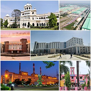
Raebareli is a city in Indian state of Uttar Pradesh. It is the administrative headquarters of Raebareli district and a part of Lucknow Division. The city is situated on the banks of the Sai river, 82 km (51 mi) southeast of Lucknow. It possesses many architectural features and sites, chief of which is a strong and spacious fort. As of 2011, Raebareli had a population of 191,316 people, in 35,197 households.
Ballia is a city with a municipal board in the Indian state of Uttar Pradesh. The eastern boundary of the city lies at the junction of two major rivers, the Ganges and the Ghaghara. The city is situated 140 km (87 mi) east of Varanasi and about 380 km from the state capital Lucknow. It is home to a protected area, the Jai Prakash Narayan bird sanctuary. Ballia is around 4 km (2.5 mi) from Bihar.

Bulandshahr district is a district in the Meerut region in the north Indian state of Uttar Pradesh (UP), situated between the Ganga and Yamuna rivers. It is a part of the National Capital Region of India, and Bulandshahr is the district headquarters.
Farrukhabad is a city in the Indian state of Uttar Pradesh. It is the administrative headquarters of the Farrukhabad tehsil. This city is on the banks of river Ganges is 295 kilometres (183 mi) from the national capital Delhi and 210 kilometres (130 mi) from the state capital Lucknow.

Anupshahr is a city and a municipal board, nearby Bulandshahr city in Bulandshahr district in the state of Uttar Pradesh, India. It is located on the bank of the holy river Ganga. It is on Bangar alluvial.
Babrala is a town and nagar panchayat in the Sambhal district in the state of Uttar Pradesh, India. Babrala is located on NH 509. Babrala is located near Narora Atomic Power Station. The prestigious Yara Fertilizers Private Limited Plant is also located in Babrala with an installed capacity of 864,600 tonnes of urea per year. Babrala is witnessing significant industrial development. Recently, the UP government approved 73 new projects for the Babrala industrial area, with four already operational. The industrial area spans over 36.04 acres and hosts various sectors, including chemicals, food and agro products, and electrical equipment.
Bhawan Bahadur Nagar is a town and a Nagar panchayat in Bulandshahr district in the state of Uttar Pradesh, India. It is also a part of the National Capital Region of Delhi. This town is near to Hapur District.
Bugrasi is a town or a Nagar panchayat in District Bulandshahr in the state of Uttar Pradesh, India. Bugrasi is about 8 km (5.0 mi) from Siyana. And 4 km (2.5 mi) from the Ganges (Ganga) river.

Dhuliyan is a municipality town in the Samserganj block of Jangipur subdivision of Murshidabad district in the state of West Bengal, India. This municipality was established in the year 1909 and comprises 21 wards. It is located between the Ganges and the Feeder canal.
Gulaothi is a town, near Bulandshahr city in the Bulandshahr district that falls under the Meerut division of the Indian state of Uttar Pradesh.
Handia is a town, near the city of Prayagraj and a nagar panchayat in the Prayagraj district of the Indian state of Uttar Pradesh.
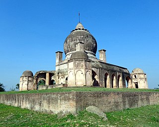
Jahangirabad is a town in Bulandshahr district in the Indian state of Uttar Pradesh. The town is named after mughal emperor Jahangir, who is said to have stayed here for a couple of days. It has various holy places like Binner Devi, Dhaka Devi, Peetambra Devi. People celebrate festivals like Holi, Radha janamshtmi, Krishna Janmashtmi etc. There is a beautiful Jahangirabad Fort built right in the center of the town. The biggest school is also there at the outskirts of the town named " St. Joseph's Sr. Sec. School".
Jewar is a town and a nagar panchayat in Gautam Buddha Nagar district in the Indian state of Uttar Pradesh. Noida, Dadri and Jewar are the 3 sub-divisions of GB Nagar district, each headed by a SDM.
Rabupura is a town and a nagar panchayat in Jewar Tehsil, Gautam Buddha Nagar district in the Indian state of Uttar Pradesh. It is situated on Yamuna Expressway. A new Film City is planned at Rabupura by the Yamuna Expressway Industrial Development Authority (YEIDA).
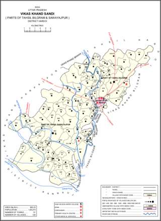
Sandi is a town and a nagar palika parishad in Bilgram tehsil of Hardoi district, Uttar Pradesh, India. It is located on the left bank of the Garra river, on the road from Hardoi to Fatehgarh. As of 2011, its population is 26,007, in 4,396 households.
Siyana is a city and a municipal board with 25 wards, situated in Siyana Tehsil in the district of Bulandshahr in the Indian state of Uttar Pradesh.
Sirathu is a town and Nagar Panchayat in Kaushambi district in the Indian state of Uttar Pradesh. It is one of oldest town in Kaushambi district. The town has a population of approximately 2700.

Unchahar is a town and nagar panchayat in Raebareli district in the Indian state of Uttar Pradesh. It serves as the headquarters of a tehsil as well as a community development block. It is located on Lucknow Allahabad Highway, 115 km from Lucknow, 85 km from Allahabad. The place is well connected by rail and roads to nearby cities of Kanpur, Lucknow, and Allahabad. Unchahar is also a constituency of Uttar Pradesh Legislative assembly.
Islamnagar is a Block and Nagar Panchayat in Badaun district in the Indian state of Uttar Pradesh. Its block code is 0174.
