This portion of National Register of Historic Places listings in Puerto Rico covers the municipality of San Juan.
Names of places given are as appear in the National Register, reflecting name as given in NRHP application at the date of listing. Note, the National Register name system does not accommodate Spanish á, ñ and other letters.
This National Park Service list is complete through NPS recent listings posted September 13, 2024. [1]
[2] | Name on the Register | Image | Date listed [3] | Location | Barrio | Description |
---|---|---|---|---|---|---|
1 | Acueducto de San Juan | June 21, 2007 (#07000585) | Flamboyán St. 18°23′21″N66°03′32″W / 18.3892°N 66.0588°W | El Cinco | Spanish-built waterworks from 1846 that was integral for the development of Río Piedras, includes an aqueduct, filtration plant and hydrological structures that make use of the nearby Piedras River. | |
2 | Administration Building | October 26, 1983 (#83004195) | University of the Sacred Heart campus, Rosales and San Antonio Sts. 18°26′33″N66°03′32″W / 18.4425°N 66.0589°W | Santurce | University of the Sacred Heart administration building and chapel built in a Classical Revival style in 1906. Also known as Portico and Chapel of the Sacred Heart University. | |
3 | Antiguo Casino de Puerto Rico | September 22, 1977 (#77001554) | 1 Ponce de León Ave. 18°27′58″N66°06′41″W / 18.4661°N 66.1114°W | San Juan Antiguo | 
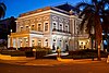
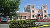
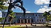
Beaux Arts casino building from 1917, used as an officers' club, music school, cultural headquarters, reception hall and event venue by the United States Army and the government of Puerto Rico throughout its history. | |
4 | Biblioteca Carnegie | October 20, 1983 (#83004196) | Ponce de León Ave., Puerta de Tierra 18°27′59″N66°06′31″W / 18.4664°N 66.1085°W | San Juan Antiguo | Classical Revival Carnegie library building from 1915 that was the first purpose-built library in the territory. | |
5 | Hiram Bithorn Municipal Stadium | January 22, 2014 (#13001118) | Franklin Delano Roosevelt Ave. 18°25′00″N66°04′23″W / 18.4167°N 66.0731°W | Hato Rey Norte | Ballpark from 1962 designed by Pedro Miranda and built to replace the smaller Sixto Escobar Stadium. In addition to serving as an event and concert venue, it has also served as the territory's national stadium and hosted the 1979 Pan American Games. | |
6 | El Capitolio de Puerto Rico | November 18, 1977 (#77001555) | Ponce de León and Muñoz Rivera Avenues 18°28′00″N66°06′21″W / 18.4668°N 66.1059°W | San Juan Antiguo | The seat of government of Puerto Rico, a Classical Revival / Beaux Arts building from 1929, designed by Rafael Carmoega and inspired by the Low Memorial Library from Columbia University. Often referred to as the Palace of the Laws (Palacio de las Leyes). | |
7 | Carcel de Puerta de Tierra [lower-alpha 1] | August 11, 1976 (#76002253) | Ponce de León Ave., Stop 8, Puerta de Tierra 18°27′49″N66°05′32″W / 18.4636°N 66.0923°W | San Juan Antiguo | 
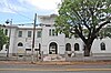
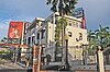
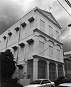
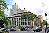
Spanish Neoclassical building from 1887 that has functioned as a prison, a Bacardi factory and public library. Today it hosts the Puerto Rico General Archives. [4] | |
8 | Casa Dr. Bailey K. Ashford | September 16, 2022 (#100008175) | 1312 Ashford Ave. 18°27′18″N66°04′10″W / 18.455034°N 66.069346°W | Santurce | Historic house and former residence of physician and Nobel Prize in Medicine nominee Bailey Ashford, former member of the Puerto Rico School of Tropical Medicine and founder of the Puerto Rico Anemia Commission. | |
9 | Casa de España | July 5, 1983 (#83002294) | Ponce de León Ave. 18°27′59″N66°06′29″W / 18.4664°N 66.1080°W | San Juan Antiguo | Exotic / Moorish Revival house from 1932, designed by Pedro Adolfo de Castro for a private Spanish-Puerto Rican social club. It includes a replica of the Court of the Lions from the Alhambra. | |
10 | Casa Gonzalez Cuyar | March 4, 2024 (#100010033) | #225 Calle del Parque 18°26′50″N66°03′51″W / 18.4473°N 66.0643°W | |||
11 | Casa Klumb | November 14, 1997 (#97001307) | 1 Ramón B. López Ave. 18°23′58″N66°02′06″W / 18.3995°N 66.0350°W | Oriente | Modernist home from 1947 designed and lived by Henry Klumb until his death. It was destroyed by a fire in 2020. | |
12 | Casa Dra. Concha Meléndez Ramírez | June 30, 2011 (#11000414) | 1400 Vilá Mayo St., at Manuel Rodríguez Serra St. 18°27′10″N66°04′02″W / 18.4527°N 66.0673°W | Santurce | Longtime home of writer, educator and first female member of the Puerto Rican Academy of Languages Concha Meléndez. The house itself is notable for its 1930s Spanish Colonial Revival architecture. Also a National Historic Landmark. | |
13 | Casa Vigil | July 23, 2018 (#100002694) | 1018 Calle Ferrocarril 18°24′00″N66°02′59″W / 18.4000°N 66.0497°W | Pueblo | 
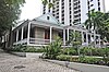
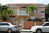
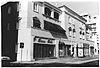
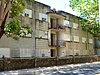
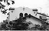
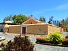
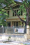
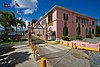
Historic vernacular residence from the late-19th century representative of the last wooden houses in the city before the construction trends shifted to concrete. | |
14 | Central High School | August 4, 1987 (#87001309) | Ponce de León Ave. 18°26′53″N66°04′11″W / 18.4481°N 66.0698°W | Santurce | Spanish Renaissance-inspired building from 1925. | |
15 | Church of San Mateo de Cangrejos of Santurce | January 2, 1985 (#85000044) | Corner of San Jorge St. and Eduardo Conde Ave. 18°26′40″N66°03′48″W / 18.4445°N 66.0634°W | Santurce | Historic 1832 parish church designed by Pedro Cobreros. Part of the Historic Churches of Puerto Rico MPS. | |
16 | Church, School, Convent and Parish House of San Agustín | December 30, 1985 (#85003194) | 265 Ponce de León Ave. 18°27′56″N66°05′56″W / 18.4656°N 66.0989°W | San Juan Antiguo | 1915 concrete church and adjacent Augustinian convent and Catholic school located in the Puerta de Tierra Historic District. | |
17 | Colegio de las Madres del Sagrado Corazón | November 25, 1985 (#85002908) | 951 Ponce de León Ave. 18°27′15″N66°04′46″W / 18.4543°N 66.0794°W | Santurce | Former Catholic convent from 1880, now part of the Conservatory of Music of Puerto Rico. | |
18 | Condado Vanderbilt Hotel | November 25, 2005 (#08001110) | 1055 Ashford Ave. 18°27′31″N66°04′34″W / 18.4587°N 66.0760°W | Santurce | Warren and Wetmore-designed Mission/Spanish Revival style hotel from 1919 that marked the beginning of the large-scale tourism industry in Puerto Rico. | |
19 | Rafael Cordero Graded School | November 19, 2020 (#100005816) | Calle Aurora Esq. Horae Prada 15 18°27′04″N66°04′51″W / 18.4511°N 66.0809°W | Santurce | A historic vocational high school building. | |
20 | Distrito Histórico del Viejo San Juan – Old San Juan Historic District | October 10, 1972 (#72001553) | Northwest triangle of San Juan Islet; also roughly bounded by Muñoz Rivera and Ponce de León Avenues, Paseo de Covadonga, and J. A. Corretejer and Recinto Sur Streets 18°27′58″N66°06′55″W / 18.4661°N 66.1154°W | San Juan Antiguo | Historic district that represents the oldest permanent European-established settlement in Puerto Rico and in the United States jurisdiction. Second set of boundaries represents a boundary increase of July 30, 2012(#12000465). Designated a National Historic Landmark District on February 27, 2013 (#13000284). | |
21 | Edificio Aboy | September 28, 2001 (#01001069) | 603 Aboy St. 18°27′15″N66°04′51″W / 18.4541°N 66.0809°W | Santurce | Art Deco building from 1937, also known as Le Faro, designed by Jorge Julia Pasarell. | |
22 | Edificio Comunidad de Orgullo Gay de Puerto Rico | May 2, 2016 (#16000237) | 3 Saldaña St. 18°24′02″N66°03′07″W / 18.4006°N 66.0519°W | Pueblo | Mediterranean Revival apartment building and former LGBT community center located in downtown Río Piedras that historically represents the first organized attempt to confront discrimination against the local LGBTQ community. | |
23 | Edificio del Valle | November 20, 2004 (#04001243) | 1118 Ponce de León Ave. 18°27′04″N66°04′31″W / 18.4512°N 66.0754°W | Santurce | Mixed-use Mission/Spanish Revival building from 1941, designed by Rafael Carmoega Morales. | |
24 | Edificio Patio Español | February 18, 2005 (#05000061) | 153 Cruz St. 18°27′57″N66°06′58″W / 18.465927°N 66.116224°W | San Juan Antiguo | Mission/Spanish Revival, Eclectic building from 1937, also known as La Filarmonica, designed by Eduardo Fossas López. | |
25 | Edificio Victory Garden | October 13, 2004 (#04001149) | 1001 Ponce de León Ave., corner of Elisa Colberg St. 18°27′13″N66°04′43″W / 18.453514°N 66.078582°W | Santurce | Mission/Spanish Revival building from 1936, designed by Pedro Adolfo de Castro. | |
26 | Escuela Brambaugh | May 5, 1989 (#89000324) | San Juan Bautista St. and Ponce de León Ave. 18°27′55″N66°05′44″W / 18.465266°N 66.095597°W | San Juan Antiguo | From 1913, also known as Puerta de Tierra Public School. | |
27 | Escuela Graduada José Celso Barbosa | May 19, 1989 (#89000406) | Ponce de León Ave. 18°27′57″N66°06′04″W / 18.465928°N 66.101217°W | San Juan Antiguo | Classical Revival style school from 1927. | |
28 | Escuela Ruiz Belvis | August 31, 2022 (#100008115) | Fernandez Juncos Ave. (formerly known as Carretera Nueva), Stop 16 1/2 Coordinates missing | |||
29 | El Falansterio de Puerta de Tierra | May 3, 1984 (#84003166) | Bounded by railroad right-of-way, Fernández Juncos Avenue, and Matías Ledesma and San Juan Bautista Streets 18°27′48″N66°05′47″W / 18.463390°N 66.096414°W | San Juan Antiguo | New Deal era Art Deco public housing complex from 1937. Originally known as the Puerta de Tierra Tenement Group Project A and established by the FERA-funded Puerto Rico Reconstruction Administration. | |
30 | Faro del Morro | October 22, 1981 (#81000693) | Summit of San Felipe del Morro Castle 18°28′16″N66°07′25″W / 18.471053°N 66.123614°W | San Juan Antiguo | Oldest lighthouse in Puerto Rico, the current Moorish Revival-style version was however first lit in 1908. Located in Castillo San Felipe del Morro. | |
31 | Figueroa Apartments | September 14, 2000 (#00001124) | 601 Fernández Juncos Ave. 18°27′26″N66°05′12″W / 18.457184°N 66.086744°W | Santurce | Art Deco building from 1935 designed by Armando Morales Cano. | |
32 | La Fortaleza | October 15, 1966 (#66000951) | Between San Juan Bay and Recinto Oeste St., at Fortaleza St. 18°27′51″N66°07′09″W / 18.464201°N 66.119294°W | San Juan Antiguo | 
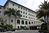
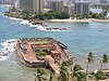
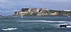
Former fortress from 1533, also known as the Santa Catalina Palace, part of the fortification system of San Juan it is now the official residence of the governor of Puerto Rico and the oldest executive mansion in continuous use in the Western Hemisphere. | |
33 | Fortín de San Gerónimo de Boquerón | October 11, 1983 (#83004199) | Puerta de Tierra 18°27′46″N66°05′03″W / 18.462841°N 66.084199°W | San Juan Antiguo | Small fortress from 1791, built at El Boquerón, in the entrance of Condado Lagoon, to provide defense against land and northeast attacks. Part of the Línea Avanzada historic district. Today it is preserved as the Military History Museum of Puerto Rico. | |
34 | La Giralda | August 11, 2008 (#08000786) | 651 José Martí St. 18°27′19″N66°05′07″W / 18.455288°N 66.085308°W | Santurce | Classical Revival and Victorian residence from 1910, designed by Francisco Valinés Cofresí. | |
35 | Gran Logia Espiritual Número 1 | June 8, 2008 (#06000507) | 1612 Antonsanti St. 18°26′46″N66°03′52″W / 18.446077°N 66.064383°W | Santurce | Classical Revival-style Spiritualist meeting hall from 1910. | |
36 | Hotel Normandie | August 29, 1980 (#80004295) | Ponce de León Ave. and San Gerónimo St. 18°27′52″N66°05′15″W / 18.464493°N 66.087412°W | San Juan Antiguo | Hotel that is a spectacular example of Streamline Moderne architecture, inspired by the Art Deco-style design of the ship SS Normandie. | |
37 | House at 659 Concordia Street | October 18, 1991 (#91001501) | 659 Concordia St., Miramar 18°27′09″N66°04′56″W / 18.452497°N 66.082298°W | Santurce | Mission/Spanish Revival house from 1935, designed by Joseph O'Kelly. | |
38 | House at 659 La Paz Street | January 30, 1992 (#91002007) | 659 La Paz St., Miramar 18°27′10″N66°04′58″W / 18.452857°N 66.082787°W | Santurce | Mission/Spanish Revival house from 1928, designed by Pedro Adolfo de Castro. | |
39 | House at 663 La Paz Street | October 18, 1991 (#91001500) | 663 La Paz St., Miramar 18°27′09″N66°04′58″W / 18.452633°N 66.082882°W | Santurce | Another Mission/Spanish Revival house designed by Pedro Adolfo de Castro. | |
40 | House at 665 McKinley Street | October 19, 1991 (#91001502) | 665 McKinley St., Miramar 18°27′19″N66°05′02″W / 18.455259°N 66.083858°W | Santurce | Vernacular Spanish Creole house from 1906. | |
41 | Instituto Loaiza Cordero para Ninos Ciegos Historic District – Distrito Historico Instituto Loaiza Cordero para Ninos Ciegos [lower-alpha 2] | October 23, 2018 (#100002935) | 1312 Fernández Juncos Ave. 18°26′50″N66°04′27″W / 18.447157°N 66.074081°W | Santurce | Former Mediterranean Revival-style hospital and school complex for blind children founded by Loaiza Cordero del Rosario in 1925. | |
42 | Rafael M. Labra High School | August 4, 1987 (#87001308) | Ponce de León and Roberto H. Todd Aves. 18°27′00″N66°04′28″W / 18.450072°N 66.074406°W | Santurce | Georgian style school building from 1916. Now functions as the Puerto Rico Museum of Contemporary Art. | |
43 | Línea Avanzada | September 25, 1997 (#97001136) | Eastern portion of the San Juan Islet 18°27′53″N66°05′26″W / 18.464645°N 66.090544°W | San Juan Antiguo | Defensive fortification system established in 1797 to defend the city of San Juan from land-based and northeastern pirate and foreign attacks. Built to complement the fortification systems of northwestern San Juan. | |
44 | Miami Building | August 23, 1984 (#84003169) | 868 Ashford Ave. 18°27′37″N66°04′50″W / 18.460336°N 66.080441°W | Santurce | Art Deco building from 1936, designed by Pedro Méndez Mercado. | |
45 | Luis Muñoz Rivera Park | November 14, 2007 (#07001195) | Ponce de León Ave., Stop 8, Puerta de Tierra 18°27′52″N66°05′28″W / 18.464406°N 66.090986°W | San Juan Antiguo | Park with Beaux Arts and Picturesque architecture and landscape design. | |
46 | Mural "La Familia" | October 23, 2017 (#100001763) | 2030 Avenida Borinquen 18°26′15″N66°03′18″W / 18.437530°N 66.055015°W | Santurce | ||
47 | General Norzagaray Bridge | July 19, 1995 (#95000833) | Highway 873, km 0.8, spanning the Quebrada Frailes 18°21′07″N66°05′29″W / 18.351816°N 66.091420°W | Caimito and Tortugo | Brick barrel vault bridge from 1855, known also as Puente de Los Frailes | |
48 | Nuestra Señora de Lourdes Chapel | September 27, 1984 (#84003171) | Ponce de León and Miramar Aves. 18°27′23″N66°05′07″W / 18.456394°N 66.085148°W | Santurce | Neo-Gothic style chapel from 1908, designed by Antonin Nechodoma | |
49 | Martín Peña Bridge | August 27, 2008 (#08000856) | Highway 25, km 8 18°26′00″N66°03′33″W / 18.433462°N 66.059045°W | Santurce, Hato Rey Norte, and Hato Rey Central | Art Deco style bridge from 1939, designed by Cecilio Delgado and others | |
50 | Polvorín de Miraflores | March 9, 1984 (#84003172) | 66 Aramania St., Old Miramar Naval Base 18°26′58″N66°05′38″W / 18.449514°N 66.093904°W | Santurce | A gunpowder magazine from 1776 | |
51 | Puerta de Tierra Historic District – Distrito Histórico de Puerta de Tierra | October 15, 2019 (#100002936) | San Juan Islet to the east of the Old San Juan Historic District 18°27′51″N66°05′54″W / 18.464040°N 66.098390°W | San Juan Antiguo | ||
52 | Puerto Rico Ilustrado – Edificio El Mundo | September 25, 1997 (#97001137) | 254 San José St. 18°27′51″N66°07′01″W / 18.464067°N 66.117004°W | San Juan Antiguo | From 1923 | |
53 | Puerto Rico Island Penitentiary | March 7, 2003 (#03000100) | South of Highway 21 18°23′19″N66°04′15″W / 18.388649°N 66.070756°W | Monacillo Urbano | Built 1933, closed 2004, demolished 2015 | |
54 | Residencia Aboy–Lompre | March 22, 1989 (#88001304) | 900 Ponce de León Ave. 18°27′16″N66°04′51″W / 18.454349°N 66.080696°W | Santurce | A Prairie School style house from 1919, designed by Antonin Nechodoma and others | |
55 | Residencia de Señoritas Universidad de Puerto Rico, Río Piedras | July 23, 2018 (#100002695) | Near the intersection of Gándara and Barbosa Aves. 18°24′09″N66°02′48″W / 18.402542°N 66.046776°W | Universidad | ||
56 | Residencia Luis Muñoz Marín | September 29, 2011 (#11000712) | Highway 877, km 0.4 18°23′12″N66°01′42″W / 18.386667°N 66.028333°W | Sabana Llana Sur | ||
57 | Río Piedras Bridge | July 19, 1995 (#95000832) | Highway 8839, km 12.5 18°23′40″N66°03′21″W / 18.394386°N 66.055958°W | El Cinco and Hato Rey Sur | A brick barrel vault bridge from 1853 | |
58 | Rum Pilot Plant | July 26, 2010 (#10000501) | Highway 1, University of Puerto Rico Agricultural Experiment Station 18°23′46″N66°03′48″W / 18.396115°N 66.063393°W | El Cinco | ||
59 | San Antonio Railroad Bridge | September 30, 2009 (#09000789) | Spanning San Antonio Channel adjacent to Highway 1 at the east end of San Juan Islet 18°27′34″N66°05′13″W / 18.459340°N 66.086891°W | San Juan Antiguo and Santurce | ||
60 | San Juan National Historic Site | October 15, 1966 (#66000930) | Old San Juan [lower-alpha 3] 18°28′10″N66°07′17″W / 18.469444°N 66.121389°W | San Juan Antiguo | Dates from 1525 | |
61 | School of Tropical Medicine | September 29, 1983 (#83002297) | Ponce de León Ave., Puerta de Tierra 18°28′01″N66°06′14″W / 18.467003°N 66.104005°W | San Juan Antiguo | Neo-Plateresque building from 1920 | |
62 | Superintendent of Lighthouses' Dwelling | October 22, 1981 (#81000694) | Coast Guard Station San Juan, La Puntilla 18°27′36″N66°07′01″W / 18.460125°N 66.116874°W | San Juan Antiguo | Hacienda style building from 1908 located inside the U.S Coast Guard base in La Puntilla | |
63 | Supreme Court Building | June 14, 2006 (#06000506) | Luis Muñoz Rivera Park 18°27′47″N66°05′18″W / 18.463189°N 66.088217°W | San Juan Antiguo | Modern Movement building from 1955 | |
64 | Templo del Maestro | April 19, 2016 (#16000189) | Constitución Ave., Stop 8 18°27′46″N66°05′24″W / 18.462777°N 66.089976°W | San Juan Antiguo | ||
65 | U.S. Custom House | February 10, 1988 (#88000075) | 1 Puntilla St. 18°27′46″N66°06′56″W / 18.462822°N 66.115522°W | San Juan Antiguo | 1924 building designed by Albert B. Nichols | |
66 | U.S. Post Office and Courthouse | March 28, 1988 (#87000694) | Block bounded by San Justo, Tanca, Commercio, and Recinto Sur Streets 18°27′50″N66°06′53″W / 18.463839°N 66.114619°W | San Juan Antiguo | From 1914, designed by Oscar Wenderoth | |
67 | University of Puerto Rico Tower and Quadrangle | May 17, 1984 (#84003174) | Ponce de León Ave. 18°24′10″N66°02′59″W / 18.402705°N 66.049684°W | Universidad | Tower and quadrangle from 1935, designed by Rafael Carmoega | |
68 | Villa Victoria | January 6, 2015 (#14001135) | 905 Ponce de León Ave. 18°27′16″N66°04′48″W / 18.454554°N 66.080045°W | Santurce |
Old San Juan is a historic district located at the "northwest triangle" of the islet of San Juan in San Juan. Its area roughly correlates to the Ballajá, Catedral, Marina, Mercado, San Cristóbal, and San Francisco sub-barrios (sub-districts) of barrio San Juan Antiguo in the municipality of San Juan, Puerto Rico. Old San Juan is the oldest settlement within Puerto Rico and the historic colonial district of the city of San Juan. This historic district is a Puerto Rico Registered Historic Zone and a National Historic Landmark District named Zona Histórica de San Juan and is listed on the United States National Register of Historic Places as the Old San Juan Historic District. Several historical buildings and structures, particularly La Fortaleza, the city walls, and El Morro and San Cristóbal castles, have been inscribed in the UNESCO World Heritage Site list since 1983. Historically the mixed-use commercial and residential real estate in the main streets of Calle Cristo and Calle Fortaleza from Calle Tanca to the Governor’s Mansion is the most valuable in the area and it has kept its value and increased steadily through several years despite the past economic turmoils.
San Juan National Historic Site in the Old San Juan section of San Juan, Puerto Rico, is a National Park Service-managed historic site which preserves and interprets the Spanish colonial-era fortification system of the city of San Juan, and features structures such as the San Felipe del Morro and San Cristóbal fortresses. This fortification system is the oldest European construction under United States jurisdiction and one of the oldest in the New World. This national historic site, together with La Fortaleza, have been designated a UNESCO World Heritage Site since 1983.
There are more than 1,500 properties and historic districts in the U.S. State of Colorado listed on the National Register of Historic Places. They are distributed over 63 of Colorado's 64 counties; only the City and County of Broomfield currently has none.
Puerta de Tierra is a subbarrio (subdistrict) occupying the eastern portion of the Islet of San Juan and the barrio of San Juan Antiguo in the municipality of San Juan, Puerto Rico. The name Puerta de Tierra derives from the former eastern gated entrance to the walled city of San Juan where Plaza Colón is today. With a population of 2,924 as of 2010, this is the most populated area of San Juan Antiguo. On October 15, 2019, it was added to the National Register of Historic Places.
This is a list of the National Register of Historic Places listings in San Juan County, Utah.
This portion of National Register of Historic Places listings in Puerto Rico is along the north coast, north plains, and north slopes of the Cordillera, from Isabela to Guaynabo.
This is a list of properties and districts in the southern municipalities of Puerto Rico that are listed on the National Register of Historic Places. It includes places along the southern coast of the island, and on the south slope of Puerto Rico's Cordillera Central.
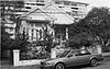
Hacienda Buena Unión in the municipality of San Germán, Puerto Rico was built in 1870. It is also known as Trapiche del Guamá or Hacienda Acosta.
This is a list of properties and districts in the western municipalities of Puerto Rico that are listed on the National Register of Historic Places. It includes places along the western coast, and on islands, and on the western slope of Puerto Rico's Cordillera Central.
This portion of National Register of Historic Places listings in Puerto Rico is along the central mountain region, from Las Marías and Maricao in the central-west to Juncos in the central-east, including the slopes of the Cordillera.
This portion of National Register of Historic Places listings in Puerto Rico covers the eastern region of Puerto Rico, from Carolina in the northeast to Arroyo in the southeast. It also includes the islands of Culebra and Vieques.
The Puerto Rico National Library is the national library of Puerto Rico. It was created in 1967 as the Biblioteca General de Puerto Rico by Joint Resolution No. 44 of the Puerto Rico Legislature. It opened on April 11, 1973. In 2003 it was renamed Biblioteca Nacional de Puerto Rico by Act 188 of August 17 of that year. The library is ascribed to the Institute of Puerto Rican Culture.
The Advanced Defense Line is a historic district consisting of four structures that formed part of the eastern defensive system of the Islet of San Juan in San Juan, Puerto Rico.
The Walls of Old San Juan is a defensive city wall that surrounds the western end of the San Juan Islet, site of the historic district of San Juan, Puerto Rico. This defensive wall system was built between the 16th and 18th centuries to protect the city and the Bay of San Juan, a highly strategic point in the Caribbean. These walls, along with the defensive fortresses in Old San Juan, form part of the UNESCO World Heritage Site-designated San Juan National Historic Site as they are characteristic examples of the historic methods of construction used in military architecture which adapted European designs and techniques to the special conditions of the Caribbean port cities.
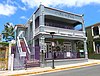
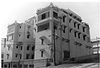
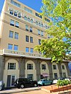
The Puerta de Tierra Phalanstery, simply known as El Falansterio and originally known as the Puerta de Tierra Tenement Group Project A, is a historic district and Art Deco public housing building complex from 1937 located in the Puerta de Tierra sub-district of San Juan, Puerto Rico.
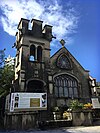
The Church, School, Convent and Parish House of San Agustín is a National Register of Historic Places (NRHP)-listed historic religious complex located in the Puerta de Tierra historic district of San Juan Antiguo in the city of San Juan, Puerto Rico. The complex consists of the Church of St. Augustine, its adjacent Augustinian convent and the parish house. The church itself was one of the first structures to be built using only concrete in the island and for this reason it is also listed in the Inventory of Historic Churches of Puerto Rico in 1990 in addition to being listed in the NRHP since 1985. The church complex is a contributing property, and, along the Capitol of Puerto Rico, it forms part of the monumental sequence of buildings, memorials and parks along the Ponce de León Avenue that constitute the Puerta de Tierra Historic District.
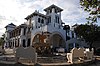
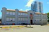
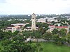
The Instituto Loaiza Cordero para Niños Ciegos, also known as the Instituto Puertorriqueño para Niños Ciegos, is a former hospital and school complex for blind children and now a historic district located in the Santurce area of the city of San Juan, Puerto Rico. The historic district is located in a large urban block in the Figueroa subbarrio of Santurce, bound by the Avenida Manuel Fernández Juncos to the northeast, Avenida Hipódromo to the southeast, Las Palmas Street to the southwest and Figueroa Street to the northwest. The historic district was added to the National Register of Historic Places in 2018 due to its historical and architectural significance.