
Quebec's Route 389 connects Route 138 adjacent to Baie-Comeau with the Newfoundland and Labrador border, connecting with the Trans-Labrador Highway to Wabush and Labrador City, and beyond to Goose Bay. On its way it skirts the eastern shore of Manicouagan Reservoir.
Route 1 is a highway in the Canada province of Newfoundland and Labrador, and is the easternmost stretch of the Trans-Canada Highway. Route 1 is the primary east–west road on the island of Newfoundland.
The Burin Peninsula is a peninsula located on the south coast of the island of Newfoundland in the province of Newfoundland and Labrador. Marystown is the largest population centre on the peninsula.

Route 340, also known as Road to the Isles, is a road in the Canadian province of Newfoundland and Labrador passing through the towns of Lewisporte, Summerford and Twillingate, all in The Isles of Notre Dame region of the province.
Route 2, also known as Pitts Memorial Drive and Peacekeeper's Way, is a 34.2-kilometre-long (21.3 mi) freeway on the Avalon Peninsula of Newfoundland in the Canadian province of Newfoundland and Labrador. The road provides a direct link from the Trans-Canada Highway (TCH) to downtown St. John's, Newfoundland, which was previously accessible only via city streets such as Topsail Road or Kenmount Road. Initially called the Harbour Arterial, construction began in the early 1970s and was completed in 1979. The $52-million project was funded by the federal and provincial governments. It was renamed by the city council in 1984 after local businessman James Stewart Pitt (1847-1914).
Route 330, also known as Road to the Shore or more commonly Gander Bay Road, is a highway that extends from Gander, Newfoundland across "the loop" passing through towns such as Gander Bay South, Carmanville, Musgrave Harbour, and Lumsden to New-Wes-Valley. Here, the highway connects with Route 320, which continues "the loop" down the west shore of Bonavista Bay exiting back to the Trans-Canada Highway in Gambo.
Route 210, also known as the Burin Peninsula Highway and Heritage Run, is a highway that extends through the Burin Peninsula from Goobies to Grand Bank, Newfoundland and Labrador. The maximum speed limit is 90 km/h except through communities and settlements where the speed limit is reduced to 50 km/h. Just after exiting Swift Current, until a few kilometres north of Marystown, much of the landscape is barren, with very few trees prevalent. After entering Marystown, motorists approach a junction where they could turn right to continue their journey on Route 210 until arriving at Grand Bank, or going straight onto Route 220 towards Burin and St. Lawrence. Marystown is the most populous community along the route.
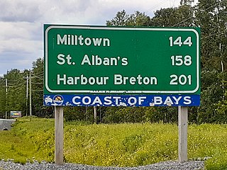
Route 360, also known as Bay d'Espoir Highway, is a provincial highway in Newfoundland and Labrador. It runs from the Bishop's Falls area to Bay d'Espoir and Harbour Breton. The road is very isolated for at least 140 kilometres (87 mi), where there are no communities or stops to refuel. Bishop's Falls and Harbour Breton are the only two settlements of any size along the entire length of Route 360, with other towns and communities being along the other highways it intersects.

Route 430 is a 413-kilometre-long (257 mi) paved highway that traverses the Great Northern Peninsula of Newfoundland in the Canadian province of Newfoundland and Labrador. The route begins at the intersection of Route 1 in Deer Lake and ends in St. Anthony. Officially known as the Great Northern Peninsula Highway, it has been designated as the Viking Trail since it is the main auto route to L'Anse aux Meadows, the only proven Viking era settlement in North America. It is the primary travel route in the Great Northern Peninsula and the only improved highway between Deer Lake and St. Anthony. It is the main access route to the Labrador Ferry terminal in St. Barbe.
Route 30 is a 12.0-kilometre-long (7.5 mi) north-south provincial highway in Newfoundland and Labrador, extending from St. John's through Logy Bay-Middle Cove-Outer Cove to Torbay, all along the Avalon Peninsula of Newfoundland.
Route 20 is a 30.2-kilometre-long (18.8 mi) provincial highway in Newfoundland and Labrador, extending from St. John's to the towns of Torbay, Flatrock, Shoe Cove, Pouch Cove, and the point of Cape St. Francis. Route 20 is located entirely on the Avalon Peninsula of Newfoundland.
Route 232 is a provincial highway in the province of Newfoundland and Labrador with the western terminus at George's Brook, where it intersects with Route 230A. The eastern terminus is at the community of Burgoyne's Cove, where the road reaches a cul-de-sac. It roughly follows the north shore of Smith Sound for the entire route.
Route 201 is a provincial road in the Canadian province of Newfoundland and Labrador. It is one of only three loop roads designated with a route number that starts and ends at the Trans-Canada Highway. The road spans 28 kilometres (17 mi), and allows for a scenic journey along the southern coast of Trinity Bay. There are quite a number of summer cottages along the route, and highway is known for an abundance of ospreys during the summer months.
Route 382, also known as Long Island Tickle Road, is a highway in the central portion of Newfoundland in the Canadian province of Newfoundland and Labrador, branching off Route 380 in the town of Pilley's Island. The route is the only provincial route with no communities prevalent – it is designed as an access to the Lushes Bight–Beaumont–Beaumont North ferry. The maximum speed limit for much of Route 382 is 60 km/h, but is reduced to 30 km/h when approaching the ferry.
Route 310, also known as Road to the Beaches, in Newfoundland and Labrador runs from its southern terminus at Glovertown, and ends at its northern terminus at the community of Salvage, all along the Eastport Peninsula of Newfoundland. A portion of this route runs through Terra Nova National Park. The route is noteworthy for its beautiful sandy beaches, particularly in the towns of Eastport and Sandy Cove. The speed limit ranges from 60–70 km/h except when traveling through a community in which the speed is reduced to 50 km/h.
Route 100 is a major highway in Newfoundland and Labrador. The highway begins at its northern terminus at the Trans-Canada Highway in the town of Whitbourne, runs for 108 kilometres (67 mi) until it ends at its southern terminus, the town of Branch, where it transitions into Route 92. Motorists can drive along the coast of Placentia Bay and eventually the Atlantic Ocean once traveling south of Point Verde.
Route 220 is the southern portion of the Heritage Run in the Canadian province of Newfoundland and Labrador, running along the southern and western coastlines of the Burin Peninsula of Newfoundland. It is a loop road, running due south from the town of Marystown and continues until the town of Grand Bank where it transitions into Route 210 - and vice versa. The speed limit along much of Route 220 is 80 km/h, except in communities where the speed limit is reduced to 50 km/h.
Route 440 is a relatively short highway in the Canadian province of Newfoundland and Labrador, on the West Coast. The highway was named in honor of Admiral Hugh Palliser. The highway starts at an interchange at Route 1 in Corner Brook, and terminates at Cox's Cove. The speed limit is 80 km/h except in communities where the speed is reduced to 50 km/h.
Route 352, also known as Fortune Harbour Road, is a 53.1-kilometre-long (33.0 mi) north-south highway on the northern coast of Newfoundland in the Canadian province of Newfoundland and Labrador. It connects the town of Northern Arm, at an intersection with Route 350, with the community of Fortune Bay, along with several other communities in between.
Route 437, also known as Cape Onion Road, is a 22.1-kilometre-long (13.7 mi) north-south highway on the northern edge of the Great Northern Peninsula of Newfoundland in the Canadian province of Newfoundland and Labrador. It connects the communities of Cape Onion-Ship Cove and Raleigh, along with Pistolet Bay Provincial Park, with Route 436 and St. Anthony.
