Route 1 is a highway in the Canada province of Newfoundland and Labrador, and is the easternmost stretch of the Trans-Canada Highway. Route 1 is the primary east–west road on the island of Newfoundland.
Route 210, also known as the Burin Peninsula Highway and Heritage Run, is a highway that extends through the Burin Peninsula from Goobies to Grand Bank, Newfoundland and Labrador. The maximum speed limit is 90 km/h except through communities and settlements where the speed limit is reduced to 50 km/h. Just after exiting Swift Current, until a few kilometres north of Marystown, much of the landscape is barren, with very few trees prevalent. After entering Marystown, motorists approach a junction where they could turn right to continue their journey on Route 210 until arriving at Grand Bank, or going straight onto Route 220 towards Burin and St. Lawrence. Marystown is the most populous community along the route.

Route 430 is a 413-kilometre-long (257 mi) paved highway that traverses the Great Northern Peninsula of Newfoundland in the Canadian province of Newfoundland and Labrador. The route begins at the intersection of Route 1 in Deer Lake and ends in St. Anthony. Officially known as the Great Northern Peninsula Highway, it has been designated as the Viking Trail since it is the main auto route to L'Anse aux Meadows, the only proven Viking era settlement in North America. It is the primary travel route in the Great Northern Peninsula and the only improved highway between Deer Lake and St. Anthony. It is the main access route to the Labrador Ferry terminal in St. Barbe.
Route 320, also the eastern portion of the Road to the Shore, starts at the Trans-Canada Highway at Gambo and runs north past Hare Bay, Dover, Indian Bay, Centreville-Wareham-Trinity, Greenspond through to New-Wes-Valley. Here, it connects with Route 330 which continues around the Cape Freels headland and exits back onto the TCH at Gander.
Route 20 is a 30.2-kilometre-long (18.8 mi) provincial highway in Newfoundland and Labrador, extending from St. John's to the towns of Torbay, Flatrock, Shoe Cove, Pouch Cove, and the point of Cape St. Francis. Route 20 is located entirely on the Avalon Peninsula of Newfoundland.
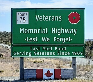
Route 75, also known as Veterans Memorial Highway, is a two-lane expressway on the Avalon Peninsula of Newfoundland. The route begins at a trumpet interchange with Route 1 and continues north, bypassing communities along the western shore of Conception Bay until it ends at a junction with Route 70 south of Carbonear. Construction of the highway was completed in 2012.
Route 10, also known as the eastern portion of the Irish Loop Drive and the Southern Shore Highway, is a 173-kilometre (107 mi) uncontrolled-access highway in Newfoundland and Labrador. Its southern terminus is at Route 90 in St. Vincent's-St. Stephen's-Peter's River, and its northern terminus is at Route 2 and The Parkway in St. John's. The route is in Division No. 1 and winds along the southern and eastern coasts of Avalon Peninsula on the island of Newfoundland.
Route 408, also known as Cape Ray Road, is a highway on the west coast of Newfoundland in the Canadian province of Newfoundland and Labrador. The intersection at Route 1 is located roughly 17 kilometres (11 mi) northeast of Channel-Port aux Basques, a nearly 20-minute drive. Upon entering Route 408, motorists would travel only 3 kilometres (1.9 mi) before entering its only community, Cape Ray. With a total distance of 5.9 kilometres (3.7 mi) between Route 1 and its terminus, the Cape Ray Lighthouse, it may hold the distinction of being the shortest provincial route that is not a bypass nor access road. Because of its short length, plus being a rough road, the maximum speed limit is set at 50 km/h.
Route 390, also known as Springdale Road, is a highway in the central portion of Newfoundland in the Canadian province of Newfoundland and Labrador. It is a very short route, running for only 11.0 kilometres (6.8 mi), with its only community, Springdale, as its terminus. Its branch routes, Route 391 and Route 392, run for a much longer distance.
Route 405, also known as Highlands Road, is a 18.0-kilometre-long (11.2 mi) minor highway in the western region of Newfoundland in the Canadian province of Newfoundland and Labrador. The highway begins at a junction with Route 1 and continues to its west terminus, the community of Highlands.
Route 403 is a minor highway in the western region of Newfoundland in the Canadian province of Newfoundland and Labrador. The highway begins at a junction with the Trans-Canada Highway and continues to its northern terminus, the community of Journois.
Route 407, also known as St. Andrew's-Searston Road, is a minor highway on the western portion of Newfoundland in the Canadian province of Newfoundland and Labrador. The route's southern terminus is the Trans-Canada Highway in the community of Tompkins, and its northern terminus is in the community of Millville, at an intersection with Route 406. Along with Route 406, Route 407 allows for an extensive view of the Codroy Valley.
Route 370, also known as the Buchans Highway, is a 73-kilometre-long (45 mi) east-west highway in the central portion of Newfoundland in the Canadian province of Newfoundland and Labrador. Its eastern terminus is the intersection at the Trans-Canada Highway in the Town of Badger, and the route ends at the Town of Buchans.
Route 420, also known as White Bay South Highway, is a 67.7-kilometre-long (42.1 mi) north-south highway located in the western region of Newfoundland in the Canadian province of Newfoundland and Labrador. It starts at its southern terminus at an intersection on the Trans-Canada Highway, near Sandy Lake, and ends at its northern terminus, the town of Jackson's Arm, passing through several other communities in between.
Route 100 is a major highway in Newfoundland and Labrador. The highway begins at its northern terminus at the Trans-Canada Highway in the town of Whitbourne, runs for 108 kilometres (67 mi) until it ends at its southern terminus, the town of Branch, where it transitions into Route 92. Motorists can drive along the coast of Placentia Bay and eventually the Atlantic Ocean once traveling south of Point Verde.
Route 450 is a highway in the Canadian province of Newfoundland and Labrador. The highway starts at an interchange at Route 1 in Corner Brook. When approaching O'Connell Drive, motorists can turn left to continue their journey along the route. The route terminates at a cul-de-sac in Lark Harbour.
Route 435 is a 33.9-kilometre-long (21.1 mi) north–south highway on the Great Northern Peninsula of Newfoundland in the Canadian province of Newfoundland and Labrador. It connects the communities on the northwestern tip of the peninsula with Route 430 and St. Anthony.
Route 461 is a 21.0-kilometre-long (13.0 mi) north–south highway on the western side of Newfoundland in the Canadian province of Newfoundland and Labrador. It connects the towns of St. George's, Barachois Brook, Mattis Point, and Stephenville Crossing.
Route 490, also known as Stephenville Access Road and Katarina Roxon Way, is a 18.7-kilometre-long (11.6 mi) north–south highway on the western coast of Newfoundland in the Canadian province of Newfoundland and Labrador. It is one of two highways that connects the town of Stephenville with the Trans-Canada Highway, with the other being Route 460.

Route 513, also known as St. Lewis Highway, is a 32.9-kilometre-long (20.4 mi) east–west highway in southeastern Labrador in the Canadian province of Newfoundland and Labrador. It connects the town of St. Lewis with the Trans-Labrador Highway. Route 513 passes through remote wooded terrain for its entire length, with no other major intersections or communities along the entire highway. The road is unpaved.
