
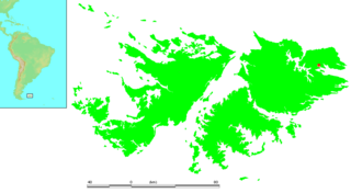
The Falkland Sound is a sea strait in the Falkland Islands. Running southwest-northeast, it separates West and East Falkland.
Port Louis is a settlement on northeastern East Falkland. It was established by Louis de Bougainville on 5 April 1764 as the first French settlement on the islands, but was then transferred to Spain in 1767 and renamed Puerto Soledad.

Port San Carlos is located on the northern bank of the inlet known as Port San Carlos, off San Carlos Water on the Western coast of East Falkland, in the Falkland Islands. It is sometimes nicknamed "KC" after former owner Keith Cameron.

UTC−03:00 is an identifier for a time offset from UTC of −03:00.

Salvador Settlement, also called Salvador, Salvador Settlement Corral, is a small harbour and settlement on East Falkland, in the Falkland Islands, It is on the north east coast, on the south shore of Port Salvador. It is one of a handful of Spanish place names on the islands, still in use.

Bluff Cove is a sea inlet and settlement on East Falkland, in the Falkland Islands, on its east coast. It was the site of secondary landings of the Falklands War of 1982, which resulted in a successful attack of the Argentine Air Force, which came to be known as the Bluff Cove Disaster.
The Wickham Heights are a rugged chain of mountains on East Falkland in the Falkland Islands. They include the island group's highest peak, Mount Usborne, Mount Wickham and are partly contiguous with No Man's Land. The slopes of Wickham Heights feature numerous stone runs, some of them extending up to 5 km (3.1 mi).

Choiseul Sound is a stretch of sea in the Falkland Islands. It runs parallel to Eagle Passage and is between Lafonia and the north of East Falkland. Lively Island is in its mouth. At its entrance, on the northern shore, is the Bertha's Beach Important Bird Area which is also a Ramsar site, recognising it as a wetland of international importance.

Johnson's Harbour is a settlement on the north east coast of East Falkland in the Falkland Islands. It is on the shore of Berkeley Sound at the head of Chabot Creek on a bay also named Johnson's Harbour. It has a small store but the FIGAS only lands there for emergencies. Surrounding hills include North Lookout, Diamond Mountain and Hawk Hill.
Green Patch is a settlement on East Falkland, in the Falkland Islands, It is on the north east coast, on the south shore of Berkeley Sound, a few miles south east from Port Louis, on Port Louis Harbour. It looks out onto Long Island and Hog Island.
Fitzroy is a settlement on East Falkland. It is divided into Fitzroy North and Fitzroy South by a tidal river called Fitzroy River that is fed from a lake on the east side of Mount Whickham. The river was forded by Charles Darwin when he visited for a second time in 1834.

Salvador Water or Port Salvador is a bay/inlet on the northeast coast of East Falkland, the largest of the Falkland Islands. It has an intricate shoreline, but could be described as being shaped like an "M".
Cape Bougainville is the second-most northerly point on East Falkland, Falkland Islands, after Cape Dolphin, and is the second-most northerly point of the two main islands, East and West Falkland. Many of the smaller islands, such as the Jason Islands, are further north.

Mare Harbour is a small settlement on East Falkland, on Choiseul Sound. It is mostly used as a port facility and depot for RAF Mount Pleasant, as well as a deepwater port used by the Royal Navy ships patrolling the South Atlantic and Antarctica, which means that the main harbour of the islands, Stanley Harbour tends to deal with commercial transport.
The Malo River, is a river in East Falkland, Falkland Islands. Its name is derived from the Breton port of St Malo, due to the French settlement established at Port Louis in 1764.
Zonda Glacier is a glacier about 8 miles (13 km) long, flowing west-southwest between Fohn Bastion and Zonda Towers into George VI Sound. The glacier was included in surveys by Falkland Islands Dependencies Survey (FIDS), 1948, and British Antarctic Survey (BAS), 1971–72, and was photographed from the air by the U.S. Navy, 1966. The name applied by United Kingdom Antarctic Place-Names Committee (UK-APC) in 1977 continues the theme of wind names in the area, as "zonda wind" is the Argentine name for the warm dry wind descending the east slopes of the Andes.
Cronus Glacier is a glacier 6 nautical miles (11 km) long and 3 nautical miles (6 km) wide flowing northwest into Bowman Inlet between the Calypso Cliffs and Crabeater Point on the east coast of the Antarctic Peninsula. It was photographed by the Ronne Antarctic Research Expedition on December 22, 1947, and roughly surveyed by the Falkland Islands Dependencies Survey in December 1958. It was named by the UK Antarctic Place-Names Committee after Cronus, the god of agriculture in Greek mythology.

Bertha's Beach Important Bird Area comprises 3300 ha of coastal wetlands at the entrance to Choiseul Sound, on the east coast of East Falkland, in the Falkland Islands. It lies about 8 km south-east of Mount Pleasant Airport and 40 km south-west of Stanley. It has been identified by BirdLife International as an Important Bird Area (IBA) because of its significancer for a variety of migratory waders and other waterbirds. Overlapping it is the 4000 ha Bertha's Beach Ramsar site, recognising it as a wetland of international importance.
Seal Bay is a bay, about 1 km across, on the rugged and exposed north coast of East Falkland in the Falkland Islands of the South Atlantic Ocean. It lies some 40 km north-west of Stanley.
