The Fan is a district of Richmond, Virginia, so named because of the "fan" shape of the array of streets that extend west from Belvidere Street, on the eastern edge of Monroe Park, westward to Arthur Ashe Boulevard. However, the streets rapidly resemble a grid after they go through what is now Virginia Commonwealth University. The Fan is one of the easterly points of the city's West End section, and is bordered to the north by Broad Street and to the south by VA 195, although the Fan District Association considers the southern border to be the properties abutting the south side of Main Street. The western side is sometimes called the Upper Fan and the eastern side the Lower Fan, though confusingly the Uptown district is located near VCU in the Lower Fan. Many cafes and locally owned restaurants are located here, as well as historic Monument Avenue, a boulevard formerly featuring statuary of the Civil War's Confederate president and generals. The only current statue is a more modern one of tennis icon Arthur Ashe. Development of the Fan district was strongly influenced by the City Beautiful movement of the late 19th century.
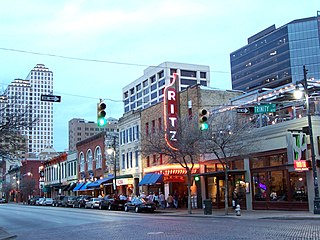
Sixth Street is a historic street and entertainment district in Austin, Texas, located within the city's urban core in downtown Austin. Sixth Street was formerly named Pecan Street under Austin's older naming convention, which had east–west streets named after trees and north–south streets named after Texas rivers.

Park Place is a neighborhood in the western half of Norfolk, Virginia. Its boundaries are roughly Granby Street on the east, Colley Avenue on the west, 23rd Street on the south and up to 38th Street to the north. Within these boundaries Park Place is made up of 4 historic subdivisions; Virginia Place, East Kensington, Park Place, and East Old Dominion Place.

Downtown Norfolk serves as the traditional center of commerce, government, and culture in the Hampton Roads region. Norfolk, Virginia's downtown waterfront shipping and port activities historically played host to numerous and often noxious port and shipping-related uses. With the advent of containerized shipping in the mid-19th century, the shipping uses located on Norfolk's downtown waterfront became obsolete as larger and more modern port facilities opened elsewhere in the region. The vacant piers and cargo warehouses eventually became a blight on downtown and Norfolk's fortunes as a whole. But in the second half of the century, Norfolk had a vibrant retail community in its suburbs; companies like Smith & Welton, High's, Colonial Stores, Goldman's Shoes, Lerner Shops, Hofheimer's, Giant Open Air, Dollar Tree and K & K Toys were regional leaders in their respective fields. Norfolk was also the birthplace of Econo-Travel, now Econo Lodge, one of the nation's first discount motel chains.

The Matewan Historic District encompasses the town center of the rural coal mining community of Matewan, West Virginia. Matewan was the scene of the Battle of Matewan on May 19, 1920, during a coal miners' strike, an event which led to the Battle of Blair Mountain, the largest insurrection ever associated with the labor movement in the United States, and was depicted in the film Matewan. It was designated a National Historic Landmark in 1997.

This is a list of the National Register of Historic Places listings in Detroit, Michigan.

The Southern Terminal is a former railway complex located at 306 West Depot Avenue in Knoxville, Tennessee, USA. The complex, which includes a passenger terminal and express depot adjacent to a large railyard, was built in 1903 by the Southern Railway. Both the terminal and depot were designed by noted train station architect Frank Pierce Milburn (1868–1926). In 1985, the terminal complex, along with several dozen warehouses and storefronts in the adjacent Old City and vicinity, were listed on the National Register of Historic Places as the Southern Terminal and Warehouse Historic District.

West Village is a neighborhood located in Detroit, Michigan, bounded by Jefferson, Kercheval, Parker, and Seyburn Avenues. Adjacent to the west is the Islandview neighborhood, and adjacent to the east is Indian Village. The district received its name in the mid-20th century because of its location just west of the more well-known Indian Village Historic District. It was listed on the National Register of Historic Places in 1980.

The Fort Madison Downtown Commercial Historic District has a collection of late-19th century store fronts centered on Ave. G, from 6th to 9th Street, and Ave. H from 7th to 9th, in Fort Madison, Iowa. It was listed on the National Register of Historic Places in 2007.

There are nine historic districts in Meridian, Mississippi. Each of these districts is listed on the National Register of Historic Places. One district, Meridian Downtown Historic District, is a combination of two older districts, Meridian Urban Center Historic District and Union Station Historic District. Many architectural styles are present in the districts, most from the late 19th century and early 20th century, including Queen Anne, Colonial Revival, Italianate, Art Deco, Late Victorian, and Bungalow.

The Greenwich Avenue Historic District is a historic district representing the commercial and civic historical development of the downtown area of the town of Greenwich, Connecticut. The district was listed on the National Register of Historic Places on August 31, 1989. Included in the district is the Greenwich Municipal Center Historic District, which was listed on the National Register the year before for the classical revival style municipal buildings in the core of Downtown. Most of the commercial buildings in the district fall into three broad styles, reflecting the period in which they were built: Italianate, Georgian Revival, and Commercial style. The district is linear and runs north–south along the entire length of Greenwich Avenue, the main thoroughfare of Downtown Greenwich, between U.S. Route 1 and the New Haven Line railroad tracks.

The Auto Freight Transport Building of Oregon and Washington, also known as East Side Terminal and Eastbank Commerce Center, in southeast Portland in the U.S. state of Oregon is a four-story commercial structure listed on the National Register of Historic Places. Built in 1924, it was added to the register in 2005.

This is a list of the National Register of Historic Places listings in Downtown and Midtown Detroit, Michigan. It is intended to be a complete list of the properties and districts on the National Register of Historic Places in Downtown and Midtown neighborhoods in Detroit, Michigan, United States. Latitude and longitude coordinates are provided for many National Register properties and districts; these locations may be seen together in online maps.

The West Freemason Street Area Historic District is a national historic district located at Norfolk, Virginia. It encompasses 48 contributing buildings in a primarily residential section on the western edge of the center city of Norfolk. It developed between the late-18th and early-20th centuries and includes notable examples of the Federal, Greek Revival, and Late Victorian styles. Notable buildings include Kenmure House Glisson House, Whittle House, McCullough Row, and the Camp-Hubard house. Located in the district is the separately listed Allmand-Archer House.
Albert F. Huntt was an architect in Richmond, Virginia. Huntt was born in Richmond in approximately 1868 and his great-grandfather, Otis Manson, was an architect who came to Richmond from New England. He studied at Pennsylvania Military Academy in Chester, Pennsylvania and married Georgiana Bartram Hathaway of Chester after graduation. He died at his home in Richmond on July 14, 1920.

The Williamston–Woodland Historic District encompasses a light industrial area of Norfolk, Virginia. It is roughly bounded by Omohundro Avenue on the west, 18th Street on the south, Church Street on the east, and the Norfolk and Southern Railroad tracks to the north. The area was developed in the late 19th and early 20th centuries, and features a mix of architectural styles, from modest commercial styles to Moderne and Art Deco structures. Most of the buildings are either warehouses or light industrial plants, ranging in height from one to three stories. The land for much of this area was owned by Theodorick Williams prior to its development.

Mount Vernon Triangle is a neighborhood and community improvement district in the northwest quadrant of Washington, D.C. The neighborhood is located adjacent to Mount Vernon Square. Originally a working-class neighborhood established in the 19th century, present-day Mount Vernon Triangle experienced a decline in the mid-20th century as it transitioned from residential to commercial and industrial use.

The Railroad Street Historic District encompasses a cluster of commercial and railroad-related buildings at the traditional late 19th-century heart of St. Johnsbury, Vermont. It includes five commercial buildings and the town's 1883 union depot, and is reflective of the town's importance as a major railroad junction in northern New England. The district was listed on the National Register of Historic Places in 1974. It was subsumed by the larger St. Johnsbury Historic District in 1980.

The Middlesboro Downtown Commercial District in Middlesboro, Kentucky is a 37 acres (15 ha) historic district which was listed on the National Register of Historic Places in 1983.

The Davenport Motor Row and Industrial Historic District or Pete Stopulos Row is a nationally recognized historic district located on the eastern edge of downtown Davenport, Iowa, United States. It was listed on the National Register of Historic Places in 2019.