Related Research Articles

The Boston Post Road was a system of mail-delivery routes between New York City and Boston, Massachusetts, that evolved into one of the first major highways in the United States.
The Southwest Corridor or Southwest Expressway was a project designed to bring an eight-lane highway into the City of Boston from a direction southwesterly of downtown. It was supposed to connect with Interstate 95 (I-95) at Route 128. As originally designed, it would have followed the right of way of the former Penn Central/New Haven Railroad mainline running from Readville, north through Roslindale, Forest Hills and Jamaica Plain, where it would have met the also-cancelled I-695. The 50-foot-wide median for the uncompleted "Southwest Expressway" would have carried the southwest stretch of the MBTA Orange Line within it, replacing the Washington Street Elevated railway's 1901/1909-built elevated railbed. Another highway, the four-lane South End Bypass, was proposed to run along the railroad corridor between I-695 in Roxbury and I-90 near Back Bay.

Forest Hills station is an intermodal transfer station in Boston, Massachusetts. It serves the MBTA rapid transit Orange Line and three MBTA Commuter Rail lines and is a major terminus for MBTA bus routes. It is located in Forest Hills, in the southern part of the Jamaica Plain neighborhood. Most Providence/Stoughton Line and Franklin Line trains, and all Amtrak Northeast Corridor trains, pass through the station without stopping.
Washington Street is a street originating in downtown Boston, Massachusetts that extends southwestward to the Massachusetts–Rhode Island state line. The majority of its length outside of the city was built as the Norfolk and Bristol Turnpike in the early 19th century. It is the longest street in Boston and remains one of the longest streets in the Commonwealth of Massachusetts. Due to various municipal annexations with the city of Boston, the name Washington Street now exists 6 or more times within the jurisdiction(s) of the City of Boston.
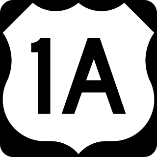
U.S. Route 1A (US 1A) is the name of several highways found in the United States.

Interstate 95 (I-95) is a part of the Interstate Highway System that parallels the East Coast of the United States from Miami, Florida, in the south to Houlton, Maine, in the north. In the US state of Massachusetts, it spans 92 miles (148 km) along a north–south axis. It is the third-longest Interstate Highway in Massachusetts, behind I-90 and I-495, while I-95 in full is the longest north–south Interstate and sixth-longest Interstate Highway in the US.

U.S. Route 6 (US 6) is a major east–west road in the U.S. state of Rhode Island. Nationally, the route continues west to Bishop, California, and east to Provincetown, Massachusetts. In western Rhode Island, it forms part of one of several routes between Hartford, Connecticut, and Providence and was planned to be replaced by Interstate 84 (I-84). The part of I-84 that was built, from I-295 to Olneyville, is now part of US 6. At Olneyville, US 6 joins Route 10 and heads east toward Downtown, Providence, where it turns south on I-95 and east on I-195. US 6 splits from I-195 in East Providence, crossing into Massachusetts on Warren Avenue. The whole route of US 6 is a state highway maintained by the Rhode Island Department of Transportation (RIDOT).

The history of Dedham, Massachusetts, from 1800 to 1899 saw growth and change come to the town. In fact, the town changed as much during the first few decades of the 19th century as it did in all of its previous history.

Route 109 is a 20.97-mile-long (33.75 km) state highway in eastern Massachusetts. It runs from Route 16 in Milford east to the VFW Parkway in Boston. Most of Route 109 runs along a portion of the Hartford and Dedham Turnpike.

U.S. Route 1 (US 1) is a major north–south U.S. Route in the state of Massachusetts, traveling through Essex, Middlesex, Suffolk, Norfolk, and Bristol counties. The portion of US 1 south of Boston is also known as the Boston–Providence Turnpike, Washington Street, or the Norfolk and Bristol Turnpike, and portions north of Boston are known as the Northeast Expressway and the Newburyport Turnpike.

The Veterans of Foreign Wars Parkway is a historic parkway in Boston, Massachusetts. The southern terminus of the parkway is at Washington Street at the Dedham-West Roxbury border, from where it travels north and then east, ending at a junction with Centre Street, near the Arnold Arboretum. The highway is almost entirely contained within the West Roxbury neighborhood, although it passes through part of the Chestnut Hill neighborhood near its junction with the West Roxbury Parkway. Most of its length, from Spring Street in West Roxbury to its eastern end, is administered by the Massachusetts Department of Conservation and Recreation (DCR), a successor to the Metropolitan District Commission (MDC) which oversaw the road's construction. The parkway was built in stages between 1930 and 1942, and was designed to provide a parkway connection from the Upper Charles River Reservation to other MDC parks via the West Roxbury Parkway. The DCR portion of the road was listed on the National Register of Historic Places in 2005. The road formerly carried the designation for U.S. Route 1.

Fort Hill is a 0.4 square mile neighborhood and historic district of Roxbury, in Boston, Massachusetts. The approximate boundaries of Fort Hill are Malcolm X Boulevard on the north, Washington Street on the southeast, and Columbus Avenue on the southwest.
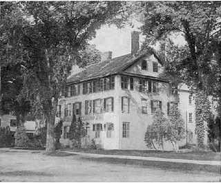
The Norfolk House also known as the Norfolk Hotel, was a tavern in Dedham, Massachusetts originally built in 1801 and located at 19 Court Street. It hosted John Quincy Adams, Andrew Jackson, and the Marquis de Lafayette.
The history of rail in Dedham, Massachusetts begins with the introduction of the first rail line in 1836 and runs to the present day. Multiple railroads have serviced Dedham since then, and current service is provided by the MBTA. The station in Dedham Square built in 1881 out of Dedham Granite was demolished in 1951 and the stones were used to put an addition on the Town's library. There are two active stations today, and multiple others in close proximity.
Ebenezer Fisher represented Dedham, Massachusetts in the Great and General Court. The Fisher School, now in Westwood, Massachusetts, was named in his honor. He served as selectman in 1785. He voted against the Norfolk and Bristol Turnpike as a member of the legislature in 1802. Fisher Ames was a driver for the road, and his brother Nathaniel believed his no vote made him a "traitor" motivated by "an ancient prejudice against the Old Parish," i.e. modern day Dedham.
The history of Dedham, Massachusetts from 1700 to 1799 saw the town become one of the largest and most influential country towns in Massachusetts. As the population grew and residents moved to outlying areas of the town, battles for political power took place. Similar battles were taking place within the churches, as liberal and conservative factions bristled at paying for ministers with whom they had differences of theological opinion. New parishes and preciencts were formed, and eventually several new towns broke away.
The Phoenix Hotel was one of the most popular social spots in Dedham during the 19th century. It was located on the northwest corner of the High Street-Washington Street intersection in modern-day Dedham Square. Among the distinguished guests of this hotel were Andrew Jackson and James Monroe.
This is a timeline of the history of the town of Dedham, Massachusetts.
19 Court Street is an historic building in Dedham, Massachusetts that was originally built in 1801 as a two-story, Federal-style single-family home. It was soon thereafter converted into a tavern, and hosted John Quincy Adams, Andrew Jackson, and the Marquis de Lafayette. In the 2010s it was converted into apartments. It has more than 15,000 square feet of living space.

Martin Marsh was a mason, tavern keeper, and businessman from Dedham, Massachusetts. He built 19 Court Street in Dedham.
References
- ↑ Hanson 1976, p. 220.
- 1 2 3 Hanson 1976, p. 221.
