Boyce is a small incorporated town in Clarke County, Virginia, United States. The population was 749 at the 2020 census, up from 589 at the 2010 census.

Elliston is a census-designated place (CDP) in Montgomery County, Virginia, United States. It lies between the city of Roanoke and the town of Christiansburg in the southwestern part of the state. The population as of the 2010 Census was 902. It is home to a small fire department, an elementary school, two gas stations, a train stop, and several churches. Most of its residents commute to larger towns. A set of railroad tracks separates the northwestern part of the town from the rest. US highway 11-460 further divides the town into two distinct neighborhoods, "Oldtown," which formed along the Valley Road in the 1850s, and "The Brake," a predominantly African-American area that developed after the Civil War.

This is a list of properties and districts in Massachusetts listed on the National Register of Historic Places. There are over 4,300 listings in the state, representing about 5% of all NRHP listings nationwide and the second-most of any U.S. state, behind only New York. Listings appear in all 14 Massachusetts counties.

Park Place is a neighborhood in the western half of Norfolk, Virginia. Its boundaries are roughly Granby Street on the east, Colley Avenue on the west, 23rd Street on the south and up to 38th Street to the north. Within these boundaries Park Place is made up of 4 historic subdivisions; Virginia Place, East Kensington, Park Place, and East Old Dominion Place.

The Depot Historic District is an industrial and commercial neighborhood in downtown Raleigh, North Carolina that was the city's railroad and warehouse distribution hub from the 1850s to 1950s. Located two blocks west of Fayetteville Street and to the north and east of the Norfolk and Southern railroad tracks, the district contains four blocks of 35 brick buildings that date from the 1880s to early 1950s. The district encompasses the southwestern portion of Raleigh's original 1792 town plan and was listed on the National Register of Historic Places in 2002.

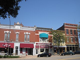
The Ayer Main Street Historic District encompasses most of the historic central business district of Ayer, Massachusetts. It extends along Main Street between Park and Columbia Streets, and was mostly developed between 1872 and 1898 as a hub of railroad and roadway-based economic activity. The district was listed on the National Register of Historic Places in 1989.

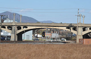
The Fort Street–Pleasant Street and Norfolk & Western Railroad Viaduct is a bridge carrying six lanes of Fort Street over both Pleasant Street and multiple tracks comprising the Norfolk Southern Railway Detroit District and Conrail Shared Assets Lincoln Secondary and Junction Yard Secondary lines on the border of the Boynton and Oakwood Heights neighborhoods in Detroit, Michigan, just west of the Rouge River. It was listed on the National Register of Historic Places in 2000. The bridge underwent massive repairs and other construction in late 2010 and throughout much of 2011, which included narrowing the Fort Street boulevard north of the viaduct into a six-lane undivided road with a left-turns-only lane. The bridge was removed from the NRHP in 2022.

Old Southwest is a neighborhood of the independent city of Roanoke, Virginia, United States. Located geographically near the center of the city, Old Southwest was annexed from Roanoke County in 1890 and developed as one of Roanoke's more affluent residential areas. Today the majority of the neighborhood falls within the Southwest Historic District listed on both the Virginia Landmarks Register and the National Register of Historic Places.

The Lower Basin Historic District is a national historic district located in Lynchburg, Virginia. The district defines a commercial and industrial warehouse area located between the downtown commercial area to the south and the James River waterfront to the north. The district contains a variety of mostly late 19th- and early 20th-century, multi-story, brick warehouses and factories, two-to-three-story brick commercial buildings, and a number of structures associated with the James River and Kanawha Canal and the Norfolk and Western and Chesapeake and Ohio Railways. The district is named for a wide basin of the canal that once extended between Ninth Street and Horseford Road, and contains 60 contributing buildings, two contributing structures, and one contributing object-a monument commemorating the site of 18th-century Lynch's Ferry.

There are nine historic districts in Meridian, Mississippi. Each of these districts is listed on the National Register of Historic Places. One district, Meridian Downtown Historic District, is a combination of two older districts, Meridian Urban Center Historic District and Union Station Historic District. Many architectural styles are present in the districts, most from the late 19th century and early 20th century, including Queen Anne, Colonial Revival, Italianate, Art Deco, Late Victorian, and Bungalow.

Petersburg Union Station is a former train station in Petersburg, Virginia. It was built in 1909–1910 for the Norfolk and Western Railway, and was later used by the Atlantic Coast Line Railroad and Amtrak.
The Belvidere South State Street Historic District is a historic district on the north side of the Kishwaukee River in Belvidere, Illinois. It is primarily composed of commercial building representative of architectural trends from 1852 to 1962, the period following the connection of the city to the Galena and Chicago Union Railroad.

Norfolk and Western Railway Company Historic District is a national historic district located in Roanoke, Virginia. It encompasses three contributing buildings constructed by the Norfolk and Western Railway (N&W). They are the Neoclassical Revival style General Office Building–South ; the Art Deco period General Office Building–North (1931); and the Moderne style Passenger Station.

The Solar Hill Historic District encompasses an architecturally significant early 20th century residential neighborhood near the center of Bristol, Virginia. The district covers an area of about 27 acres (11 ha), bounded on the north by the Norfolk and Southern Railroad and Scott Street, on the west by West Street, on the east by Johnson Street, and on the south by Cumberland Street. Solar Hill is a knob of land overlooking the downtown area, and is where the house of the King family, one the area's early settlers, is located. The Kings owned most of what is now Bristol until 1852, when the central portion of the town was laid out, but retained ownership of the Solar Hill area until after the American Civil War. The hill became known as "Solar Hill" when it was used as an official observation point of a solar eclipse in 1869.
The Roanoke River and Railroad Historic District is a predominantly industrial area on the north side of the Roanoke River in Roanoke, Virginia. The area is bounded by South Jefferson Street on the west and the Roanoke River to the east, and extends north as far as Albemarle Avenue. The district's resources are defined primarily by their relationship to the railroad tracks that bisect this area. The area was developed in the late 19th and early 20th centuries with the completion of the Roanoke & Southern line in 1892 and the Virginian Railway line in 1909, and consists primarily of functional industrial buildings that were built between about 1900 and 1930, an example of which is the Virginia Can Company. Notable exceptions are the Virginian Railway Passenger Station, a Spanish Revival passenger station built 1909-10 and listed on the National Register of Historic Places since 2003, and the Walnut Street and Jefferson Street bridges, completed in 1927 and 1928, respectively. Both bridges were constructed in the Art Deco style and designed with "Egyptian Babylonian" style decorations.

The Williamston–Woodland Historic District encompasses a light industrial area of Norfolk, Virginia. It is roughly bounded by Omohundro Avenue on the west, 18th Street on the south, Church Street on the east, and the Norfolk and Southern Railroad tracks to the north. The area was developed in the late 19th and early 20th centuries, and features a mix of architectural styles, from modest commercial styles to Moderne and Art Deco structures. Most of the buildings are either warehouses or light industrial plants, ranging in height from one to three stories. The land for much of this area was owned by Theodorick Williams prior to its development.

The Depot Square Historic District encompasses the historic commercial business district of Randolph, Vermont. Developed in the mid-19th century around the facilities of the Central Vermont Railway, the area features a high concentration of well-preserved Second Empire and late Victorian commercial architecture. It was listed on the National Register of Historic Places in 1975.

The Rockwood Road Historic District encompasses a portion of the town center of Norfolk, Massachusetts that has retained significant 19th-century characteristics. It extends along Rockwood Road from the MBTA Commuter Rail line to Boardman Street. This area consists mainly of residential or former residential buildings, as well as the 1863 Norfolk Grange Hall, a former church, and is reflective of the center's growth as a railroad village. The district was added to the National Register of Historic Places in 2017.

The Delaware Railroad was the major railroad in the US state of Delaware, traversing almost the entire state north to south. It was planned in 1836 and built in the 1850s. It began in Porter and was extended south through Dover, Seaford and finally reached Delmar on the border of Maryland in 1859. Although operated independently, in 1857 it was leased by and under the financial control of the Philadelphia, Wilmington, and Baltimore Railroad. In 1891, it was extended north approximately 14 miles (23 km) with the purchase of existing track to New Castle and Wilmington. With this additional track, the total length was 95.2 miles (153.2 km).