Northern Highway (Victoria)

Last updated

Northern Highway

Australia Victoria location map.svg
Red pog.svg
North end
Red pog.svg
South end
Coordinates
General information
TypeHighway
Length164.8 km (102 mi) [1]
Gazetted November 1914 (as Main Road) [2]
July 1925 (as State Highway) [3]
Route number(s) AUS Alphanumeric Route B75.svg B75 (1997–present)
Former
route number
  • Australian national route 75.svg National Route 75 (1955–1997)
    Entire route
  • Australian national highway 31.svg National Highway 31 (1974–1976)
  • Australian national route 31.svg National Route 31 (1954–1974)
    (Kilmore–Beveridge)
Major junctions
North endAUS Alphanumeric Route B75.svg Cobb Highway
VIC/NSW border
 
South endAUS Alphanumeric Route M31.svg Hume Freeway
Beveridge, Victoria
Location(s)
Region Loddon Mallee, Hume [4]
Major settlements Rochester, Elmore, Heathcote, Kilmore, Wallan
Highway system

Northern Highway is a rural highway in northern Victoria, linking Echuca on the banks of the Murray River with Beveridge a short distance north of the northern suburban fringes of Melbourne. [5] In conjunction with McIvor Highway, it provides an important link between Melbourne and Bendigo. It forms a significant freight route providing access to markets and ports in Melbourne and the rural primary production areas of the Murray Valley and southern New South Wales, and serves a number of agricultural and tourism-related industries along its length.

Contents

Route

Northern Highway commences at the state border with New South Wales as a continuation of Cobb Highway into Victoria and heads in a southerly direction as a two-lane, single carriageway rural highway through the western part of the regional town of Echuca, running concurrent with Murray Valley Highway for a short period, before continuing south through flat open country through Rochester, Elmore and Heathcote, then traverses moderately hilly terrain through Kilmore and Wallan, before eventually terminating at the interchange with Hume Freeway a short distance south of Wallan in Beveridge.

History

The passing of the Country Roads Act of 1912 [6] through the Parliament of Victoria provided for the establishment of the Country Roads Board (later VicRoads) and their ability to declare Main Roads, taking responsibility for the management, construction and care of the state's major roads from local municipalities. Kilmore-Heathcote(-Bendigo) Road was declared a Main Road, from Kilmore to Pyalong on 30 November 1914, [2] and from Pyalong and Heathcote (and continuing west to Bendigo) on 28 May 1915; [7] Heathcote-Elmore Road was declared a Main Road, between Tooleen and Elmore on 17 March 1915, [8] and between Heathcote and Tooleen on 28 May 1915; [9] and Bendigo-Echuca Road between north-eastern Bendigo and Elmore was declared a Main Road on 17 May 1915. [9]

The passing of the Highways and Vehicles Act of 1924 [10] provided for the declaration of State Highways, roads two-thirds financed by the State government through the Country Roads Board. Northern Highway was declared a State Highway on 1 July 1925, [3] cobbled from a collection of roads from Bendigo through Elmore and Rochester to Echuca (for a total of 55 miles), subsuming the original declaration of Bendigo-Echuca Road. In the 1947/48 financial year, its southern end was rerouted south of Elmore: instead of running to Bendigo, it was extended further south via Heathcote to meet Hume Highway at Kilmore, [11] subsuming the original declarations of Heathcote-Elmore Road and Kilmore-Heathcote-Bendigo Road as Main Roads; the previous alignment of Northern Highway from Elmore to Bendigo was subsumed into Midland Highway. Northern Highway was extended south one last time when the Kilmore bypass was opened in 1976, from Kilmore to Beveridge (just south of Wallan) along the former alignment of Hume Highway.

Northern Highway was later signed National Route 75 in 1955; with Victoria's conversion to the newer alphanumeric system in the late 1990s, this was updated to route B75.

The passing of the Road Management Act 2004 [12] granted the responsibility of overall management and development of Victoria's major arterial roads to VicRoads: in 2022, VicRoads re-declared this road as Northern Highway (Arterial #6540), beginning in Echuca and ending in Beveridge. [5]

Attractions

Major intersections and towns

StateLGALocation [1] [5] km [1] miDestinationsNotes
New South Wales Murray River Moama 0.00.0AUS Alphanumeric Route B75.svg Cobb Highway (B75)  Deniliquin, Hay, Wilcannia Southern terminus of Cobb Highway, route B75 continues north
River Murray Dhungala Bridge
State borderNew South Wales – Victoria state border
Victoria Campaspe Echuca AUS Alphanumeric Route B75.svg Northern Highway (B75)Northern terminus of Northern Highway
Campaspe River 1.10.68Yakoa Bridge
Campaspe Echuca 1.50.93AUS Alphanumeric Route C349.svg Warren Street (C349)  Echuca, Moama Roundabout
3.01.9AUS Alphanumeric Route B400.svg Murray Valley Highway (B400 north)  Kerang, Swan Hill, Mildura Concurrency with route B400
4.22.6AUS Alphanumeric Route B400.svg Murray Valley Highway (B400 east)  Cobram, Wodonga, Corryong
8.95.5AUS Alphanumeric Route C334.svg Echuca-Mitiamo Road (C334)  Mitiamo, Durham Ox
Ballendella22.614.0AUS Alphanumeric Route C341.svg Prairie-Rochester Road (C341)  Tennyson, Prairie
Waranga Western Channel 25.916.1Bridge (name unknown)
Campaspe Rochester 29.318.2AUS Alphanumeric Route C362.svg Webb Road (C362)  Kyabram,
to AUS Alphanumeric Route C347.svg Heathcote-Rochester Road (C347 south)  Corop, Heathcote
29.818.5 Echuca railway line
Greater Bendigo Elmore 46.729.0AUS Alphanumeric Route C337.svg Elmore–Raywood Road (C337)  Kamarooka, Raywood
47.129.3AUS Alphanumeric Route A300.svg Midland Highway (A300 west)  Bendigo, Ballarat, Geelong Concurrency with route A300
Campaspe Runnymede48.730.3AUS Alphanumeric Route A300.svg Midland Highway (A300 east)  Shepparton, Benalla, Mansfield
Creek View60.337.5AUS Alphanumeric Route C345.svg Bendigo-Murchison Road (C345)  Rushworth, Murchison, Violet Town
Greater Bendigo Ladys View85.553.1AUS Alphanumeric Route C347.svg Heathcote-Rochester Road (C347 north)  Corop, Elmore
McIvor Creek96.259.8Bridge (name unknown)
Greater Bendigo Heathcote 96.359.8AUS Alphanumeric Route B280.svg McIvor Highway (B280)  Axedale, Bendigo
97.260.4AUS Alphanumeric Route C326.svg Heathcote-Redesdale Road (C326)  Redesdale, Kyneton
Argyle 101.763.2AUS Alphanumeric Route C344.svg Heathcote-Nagambie Road (C344)  Nagambie
Mitchell Tooborac 113.770.6AUS Alphanumeric Route C384.svg Seymour-Tooborac Road (C384)  Puckapunyal, Seymour
114.971.4AUS Alphanumeric Route C325.svg Lancefield–Tooborac Road (C325)  Lancefield, Sunbury
Kilmore 144.089.5AUS Alphanumeric Route C311.svg Broadford–Kilmore Road (C311)  Broadford
147.391.5AUS Alphanumeric Route C324.svg Kilmore-Lancefield Road (C324)  Lancefield, Woodend
150.793.6AUS Alphanumeric Route C729.svg Wandong Road (C729)  Wandong, Epping
Wallan 161.2100.2AUS Alphanumeric Route C727.svg Watson Street (C727 east, unallocated west)  Whittlesea,
to AUS Alphanumeric Route M31.svg Hume Freeway (M31 north)  Seymour, Wodonga, Sydney
Beveridge 164.8102.4AUS Alphanumeric Route M31.svg Hume Freeway (M31 south)  Craigieburn, Thomastown, Melbourne Southern terminus of highway and route B75
Southern exit and northern entrance only
1.000 mi = 1.609 km; 1.000 km = 0.621 mi

See also

Australia road sign W5-29.svg Australian Roadsportal

Related Research Articles

<span class="mw-page-title-main">Hume Highway</span> Major national highway in Australia

Hume Highway, inclusive of the sections now known as Hume Freeway and Hume Motorway, is one of Australia's major inter-city national highways, running for 840 kilometres (520 mi) between Melbourne in the southwest and Sydney in the northeast. Upgrading of the route from Sydney's outskirts to Melbourne's outskirts to dual carriageway was completed on 7 August 2013.

<span class="mw-page-title-main">Shire of Mitchell</span> Local government area in Victoria, Australia

Mitchell Shire is a local government area in the Hume region of Victoria, Australia, located North of Melbourne. It covers an area of 2,862 square kilometres (1,105 sq mi) and, in April 2024, had a projected population of 61,362. Larger towns include Beveridge, Broadford, Kilmore, Seymour, Tallarook, Pyalong and Wallan. It was formed in 1994 from the amalgamation of the Shire of Pyalong, the Shire of Kilmore, most of the Shire of Broadford, and parts of the Shire of McIvor and Rural City of Seymour.

<span class="mw-page-title-main">Calder Highway</span> Highway in Victoria

Calder Highway is a rural highway in Australia, linking Mildura and the Victoria/New South Wales border to Bendigo, in North Central Victoria. South of Bendigo, where the former highway has been upgraded to freeway-standard, Calder Freeway links to Melbourne, subsuming former alignments of Calder Highway; the Victorian Government completed the conversion to freeway standard from Melbourne to Bendigo on 20 April 2009.

<span class="mw-page-title-main">Maroondah Highway</span> Highway in Victoria, Australia

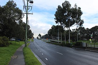
Maroondah Highway is a major east–west thoroughfare in the eastern suburbs of Melbourne, and a highway connecting the north-eastern fringes of Melbourne to Mansfield, at the lower alpine region of Victoria, Australia.

Loddon Valley Highway runs roughly north-west from Bendigo to Kerang. It constitutes part of the direct route from Melbourne to the popular Murray River holiday areas around Swan Hill.

<span class="mw-page-title-main">Sunraysia Highway</span> Highway in Victoria

Sunraysia Highway is a 330 kilometres (205 mi) north–south rural highway in western Victoria, linking Ouyen to the north-western Ballarat suburb of Mitchell Park, and acts as a secondary route to Calder Highway, the main route between Melbourne and Mildura. It serves a number of important industries in the region such as agriculture, viticulture, food processing, winemaking and tourism. It forms an important link for these industries to markets and ports in the south of Victoria and South Australia.

<span class="mw-page-title-main">Goulburn Valley Highway</span>

Goulburn Valley Highway is a highway located in Victoria, Australia, linking Tocumwal on the Murray River through North Central Victoria to Eildon. The section north of the Hume Freeway is part of the Melbourne to Brisbane National Highway and is the main link between these two cities, as well as a major link between Victoria and inland New South Wales. It is also the most direct route between Melbourne and the major regional centre of Shepparton in Victoria.

<span class="mw-page-title-main">Murray Valley Highway</span> Highway in Victoria and New South Wales

Murray Valley Highway is a 663-kilometre (412 mi) rural highway located in Victoria, Australia, between Euston, New South Wales and Corryong, Victoria. The popular tourist route mostly follows the southern bank of the Murray River and effectively acts as the northernmost highway in Victoria. For all but the western end's last three kilometres, the highway is allocated route B400.

McIvor Highway is a short Victorian highway (44 km) linking Bendigo and Heathcote. Together with Hume Freeway and Northern Highway, it provides an alternative route between Melbourne and Bendigo. The name 'McIvor' refers to the original name of the Heathcote region, used during the Victorian Gold Rush.

<span class="mw-page-title-main">Kilmore, Victoria</span> Town in Victoria, Australia

Kilmore is a town in the Australian state of Victoria. Located 65 kilometres (40 mi) north of Melbourne, it is the oldest inland town in Victoria by the combination of age and physical occupation, and because it had unique agricultural attributes to drive that earliest settlement. It grew very rapidly to become four times bigger than its nearest inland rival by 1851. Its spectacular growth continued to match that of the major gold mining towns of Ballarat, Bendigo and Beechworth until at least 1861.

Midland Highway is a major rural highway linking major towns in Victoria, beginning from Geelong and winding through country Victoria in a large arc through the cities of Ballarat, Bendigo and Shepparton, eventually reaching Mansfield at the foothills of the Victorian Alps.

<span class="mw-page-title-main">Pyrenees Highway, Victoria</span> Highway in western Victoria, Australia

Pyrenees Highway is a rural highway in western Victoria, Australia, linking Ararat to Elphinstone. It was named after the Pyrenees ranges, the set of low mountain ridges the road travels through.

The Tocumwal railway line is a 1,600 mm gauge railway line in Victoria, Australia. The line runs between the border town of Tocumwal in New South Wales to Southern Cross, Melbourne. The line is utilised by various passenger and freight trains serving the northern suburbs of Melbourne and northern regions of Victoria.

The Deniliquin railway line is a broad-gauge railway line serving northwestern Victoria, Australia. The line runs from the New South Wales town of Deniliquin into Bendigo, before turning south-southeast towards Melbourne, terminating in Docklands near the central business district. It is a major trunk line both for passenger and freight trains, with many railway lines branching off from it.

<span class="mw-page-title-main">Omeo Highway</span> Highway in Victoria

Omeo Highway is a 163 kilometre rural highway in eastern Victoria, Australia, connecting Tallangatta on Lake Hume in north-east Victoria to Bairnsdale in East Gippsland, over parts of the Victorian Alps.

<span class="mw-page-title-main">Wimmera Highway</span> Highway in Victoria and South Australia

Wimmera Highway is a 345 kilometre rural highway that runs predominately through the Wimmera region of western Victoria, after which the highway is named. It links the towns of Marong, Victoria, just to the west of the major regional centre of Bendigo in Victoria, and Naracoorte, in the south-eastern corner of South Australia.

<span class="mw-page-title-main">Shire of Kilmore</span> Local government area in Victoria, Australia

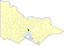
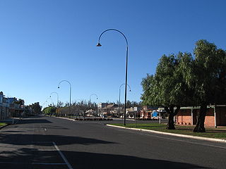
The Shire of Kilmore was a local government area about 60 kilometres (37 mi) north of Melbourne, the state capital of Victoria, Australia. The shire covered an area of 508.9 square kilometres (196.5 sq mi), and existed from 1856 until 1995.

The Broadford Football Netball Club, nicknamed the Roos, is an Australian rules football and netball club and located 88 km north of Melbourne in the town of Broadford and is affiliated with the AFL Outer East.

The Wallan Football Netball Club, nicknamed the Magpies, is an Australian rules football club located 45 km north of Melbourne in the town of Wallan and is affiliated with the Riddell District Football League and wears black and white vertical stripes.

The Heathcote railway line was a cross-country link between Bendigo and Heathcote Junction. It was partly opened in 1888 and, by 1890, it was fully operational. It was partially closed in 1958 and fully closed in 1968.
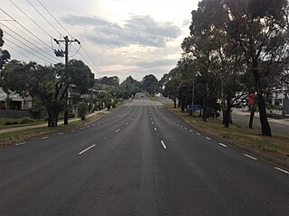
References

  1. 1 2 3 Google (28 June 2024). "Northern Highway" (Map). Google Maps . Google. Retrieved 28 June 2024.
  2. 1 2 "Victorian Government Gazette". State Library of Victoria. 9 December 1914. p. 5527. Retrieved 28 June 2024.
  3. 1 2 "Country Roads Board Victoria. Twelfth Annual Report: for the year ended 30 June 1925". Country Roads Board of Victoria. Melbourne: Victorian Government Library Service. 31 December 1925. p. 3.
  4. "Victoria's Regions". Regional Development Victoria. Victoria State Government. 11 August 2021. Retrieved 16 June 2022.
  5. 1 2 3 VicRoads. "VicRoads – Register of Public Roads 2024". Government of Victoria. p. 929. Archived from the original on 19 June 2024. Retrieved 19 June 2024.
  6. An Act relating to Country Roads State of Victoria, 23 December 1912
  7. "Victorian Government Gazette". State Library of Victoria. 9 June 1915. p. 2028. Retrieved 11 July 2024.
  8. "Victorian Government Gazette". State Library of Victoria. 24 March 1915. p. 1102. Retrieved 3 July 2024.
  9. 1 2 "Victorian Government Gazette". State Library of Victoria. 2 June 1915. p. 1944. Retrieved 9 July 2024.
  10. An Act to make further provision with respect to Highways and Country Roads Motor Cars and Traction Engines and for other purposes State of Victoria, 30 December 1924
  11. "Country Roads Board Victoria. Thirty-Fifth Annual Report: for the year ended 30 June 1948". Country Roads Board of Victoria. Melbourne: Victorian Government Library Service. 1 November 1948. p. 7.
  12. State Government of Victoria. "Road Management Act 2004" (PDF). Government of Victoria. Archived (PDF) from the original on 18 October 2021. Retrieved 19 October 2021.