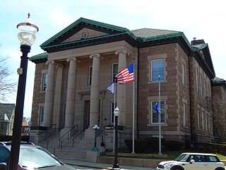
Westerly is a town on the southwestern coastline of Washington County, Rhode Island, United States, first settled by English colonists in 1661 and incorporated as a municipality in 1669. It is a beachfront community on the south shore of the state with a population of 23,359 as of the 2020 census.
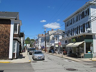
Stonington is a town located in New London County, Connecticut. The municipal limits of the town include the borough of Stonington, the villages of Pawcatuck, Lords Point, and Wequetequock, and the eastern halves of the villages of Mystic and Old Mystic. Stonington is part of the Southeastern Connecticut Planning Region. The population of the town was 18,335 at the 2020 census.

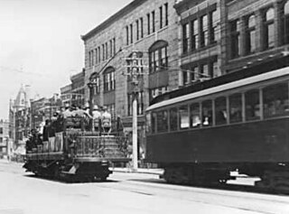
The interurban is a type of electric railway, with tram-like electric self-propelled rail cars which run within and between cities or towns. The term "interurban" is usually used in North America, with other terms used outside it. They were very prevalent in many parts of the world before the Second World War and were used primarily for passenger travel between cities and their surrounding suburban and rural communities. Interurban as a term encompassed the companies, their infrastructure, their cars that ran on the rails, and their service. In the United States, the early 1900s interurban was a valuable economic institution, when most roads between towns, many town streets were unpaved, and transportation and haulage was by horse-drawn carriages and carts.
The British Columbia Electric Railway (BCER) was an historic railway which operated in southwestern British Columbia, Canada. Originally the parent company for, and later a division of, BC Electric Company, the BCER assumed control of existing streetcar and interurban lines in southwestern British Columbia in 1897, and operated the electric railway systems in the region until the last interurban service was discontinued in 1958. During and after the streetcar era, BC Electric also ran bus and trolleybus systems in Greater Vancouver and bus service in Greater Victoria; these systems subsequently became part of BC Transit, and the routes in Greater Vancouver eventually came under the control of TransLink. Trolley buses still run in the City of Vancouver with one line extending into Burnaby.

The Pawcatuck River is a river in the US states of Rhode Island and Connecticut flowing approximately 34 miles (55 km). There are eight dams along the river's length. USS Pawcatuck was named after the river.
Southern New England at one time had a large network of street railway lines, including several true interurban streetcars. It was possible to go from New York City to Boston completely on streetcars on at least three routes: via Hartford, Connecticut, Springfield, Massachusetts, and Worcester, Massachusetts; via New London, Connecticut and Worcester, or via New London and Providence, Rhode Island.

The New York, Providence and Boston Railroad, normally called the Stonington Line, was a major part of the New York, New Haven and Hartford Railroad between New London, Connecticut and Providence, Rhode Island. It is now part of Amtrak's high-speed Northeast Corridor.

The Sacramento Northern Railway was a 183-mile (295 km) electric interurban railway that connected Chico in northern California with Oakland via the state capital, Sacramento. In its operation it ran directly on the streets of Oakland, Sacramento, Yuba City, Chico, and Woodland. This involved multiple car trains making sharp turns at street corners and obeying traffic signals. Once in open country, SN's passenger trains ran at fairly fast speeds. With its shorter route and lower fares, the SN provided strong competition to the Southern Pacific and Western Pacific Railroad for passenger business and freight business between those two cities. North of Sacramento, both passenger and freight business was less due to the small town agricultural nature of the region and due to competition from the paralleling Southern Pacific Railroad.

The Connecticut Company was the primary electric street railway company in the U.S. state of Connecticut, operating both city and rural trolleys and freight service. It was controlled by the New York, New Haven and Hartford Railroad, which also controlled most steam railroads in the state. After 1936, when one of its major leases was dissolved, it continued operating streetcars and, increasingly, buses in certain Connecticut cities until 1976, when its assets were purchased by the state government.
Sun Publishing Company is a daily and weekly newspaper publisher in southwest Rhode Island and southeast Connecticut, United States. It is a Westerly, Rhode Island-based subsidiary of RISN Operations.
The Aurora, Elgin & Fox River Electric (AE&FRE), was an interurban railroad that operated freight and passenger service on its line paralleling the Fox River. It served the communities of Carpentersville, Dundee, Elgin, South Elgin, St. Charles, Geneva, Batavia, North Aurora, Aurora, Montgomery, and Yorkville in Illinois. It also operated local streetcar lines in both Aurora and Elgin.
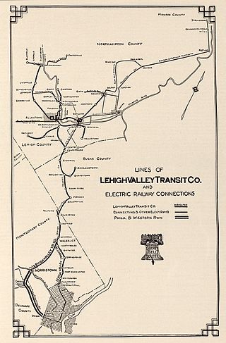
The Lehigh Valley Transit Company (LVT) was a regional transport company that was headquartered in Allentown, Pennsylvania. The company began operations in 1901, as an urban trolley and interurban rail transport company. It operated successfully into the 1930s, but struggled financially during the Great Depression, and was saved from abandonment by a dramatic ridership increase during and following World War II.

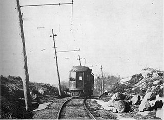
The Groton and Stonington Street Railway was an interurban trolley line that extended from Groton, Connecticut, to Westerly, Rhode Island, with a later branch to Old Mystic, Connecticut, and an extension to New London. The line operated from 1904 to 1919 and 1923 to 1928, after which it was replaced by buses.

The Venice Short Line was a Pacific Electric (PE) interurban railway line in Los Angeles which traveled from downtown Los Angeles to Venice, Ocean Park, and Santa Monica via Venice Boulevard. The route was especially busy on Sundays, as Venice was PE's most popular beachfront destination.
The Shore Line Electric Railway was a trolley line along the southern coastline of Connecticut, running between New Haven and Old Saybrook with additional branches to Chester and Stony Creek. Unlike most trolley lines in New England, the Shore Line Electric was a true interurban, running large railway-style cars largely on a private right-of-way rather than on public streets. Though its main line was in operation for only 15 nonconsecutive years, the Shore Line Electric briefly acquired a substantial network of trolley lines stretching across eastern Connecticut, including the Norwich and Westerly Railway, the Groton and Stonington Street Railway, and several lines of the Connecticut Company. Most of the trolley line no longer is extant, however, the Shore Line Electric Railway Power House still stands along the mouth of the Connecticut River in Old Saybrook.

The New London and East Lyme Street Railway was a streetcar line that operated in southeastern Connecticut. Its main line ran from New London to Niantic with a later extension to Crescent Beach and a branch to Old Saybrook.
The Portland–Lewiston Interurban (PLI) was an electric railroad subsidiary of the Androscoggin Electric Company operating from 1914 to 1933 between Monument Square in Portland and Union Square in Lewiston, Maine. Hourly service was offered over the 40-mile (64 km) route between the two cities. Express trains stopping only at West Falmouth, Gray, New Gloucester, Upper Gloucester and Danville made the trip in 80 minutes, while trains making other local stops upon request required 20 minutes more. The line was considered the finest interurban railroad in the state of Maine.
The San Bernardino–Riverside is a former Pacific Electric (PE) interurban railway line in the Inland Empire. Unlike most of the company's services, trains did not travel to Downtown Los Angeles and instead provided a suburban service between San Bernardino and Riverside.

The Venice–Inglewood Line is a former railway line in Los Angeles County, California. The route was established by the Atchison, Topeka and Santa Fe Railway in 1887 before eventually being absorbed into the Pacific Electric interurban railway system. Service under electrification was very sparse, providing a suburban route between Venice and Inglewood.


