Nxuba Local Municipality

Last updated

Nxuba
Nxuba CoA.png
Map of the Eastern Cape with Nxuba highlighted.svg
Location in the Eastern Cape
Coordinates: 32°42′S26°18′E / 32.700°S 26.300°E / -32.700; 26.300
Country South Africa
Province Eastern Cape
District Amathole
Seat Adelaide
Wards 4
Government
[1]
  Type Municipal council
  Past MayorLouisa Leonora Bruintjies
Area
  Total2,732 km2 (1,055 sq mi)
Population
 (2011) [2]
  Total24,264
  Density8.9/km2 (23/sq mi)
Racial makeup (2011)
[2]
   Black African 73.5%
   Coloured 20.6%
   Indian/Asian 0.3%
   White 4.9%
First languages (2011)
[2]
   Xhosa 69.3%
   Afrikaans 24.2%
   English 4.4%
  Other2.1%
Time zone UTC+2 (SAST)
Municipal codeEC128

Nxuba Local Municipality formerly known as Cradock Local Municipality, was an administrative area in the Amatole District of the Eastern Cape in South Africa. The Fish River, as it is now called, was first named Nxuba River by King Sandile in the 18th century [3] After municipal elections on 3 August 2016 it was merged into the larger Raymond Mhlaba Local Municipality.

Contents

Main places

The 2001 census divided the municipality into the following main places: [4]

PlaceCodeArea (km2)Population
Adelaide 21701 2.473,771
Bedford 21702 2.543,097
Lingelethu 21703 3.548,274
Sizakhele 21705 1.255,486
Remainder of the municipality 21704 2,724.604,207

Politics

The municipal council consisted of eight members elected by mixed-member proportional representation. Four councillors were elected by first-past-the-post voting in four wards, while the remaining four were chosen from party lists so that the total number of party representatives was proportional to the number of votes received. In the election of 18 May 2011 the African National Congress (ANC) won a majority of five seats on the council. The following table shows the results of the election. [5] [6]

PartyVotesSeats
WardListTotal %WardListTotal
ANC 4,2904,3188,60859.9415
DA 1,5091,5283,03721.1022
Nxuba Community Organisation8097441,55310.8011
COPE 3033016044.2000
Adelaide Residents Association2442224663.2000
Bedford Residents' Association63481110.8000
Total7,2187,16114,379100.0448
Spoilt votes240238478

Related Research Articles

<span class="mw-page-title-main">Emnambithi-Ladysmith Local Municipality</span> Local municipality in KwaZulu-Natal, South Africa

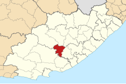
Emnambithi-Ladysmith Local Municipality was a municipality in the Uthukela District Municipality, KwaZulu-Natal, South Africa. It is accessible from the N3 and N11 national highways.

<span class="mw-page-title-main">Makhuduthamaga Local Municipality</span> Local municipality in Limpopo, South Africa

Makhuduthamaga Municipality is a local municipality within Sekhukhune District Municipality, in the Limpopo province of South Africa.

<span class="mw-page-title-main">Gariep Local Municipality</span> Former local municipality in Eastern Cape, South Africa

Gariep Local Municipality is a defunct local municipality in Joe Gqabi District Municipality, Eastern Cape. The municipality was merged with Maletswai Local Municipality immediately after the August 2016 Local Municipal Elections to form the new Walter Sisulu Local Municipality.

<span class="mw-page-title-main">Albert Luthuli Local Municipality</span> Local municipality in Mpumalanga, South Africa

Albert Luthuli Municipality is a local municipality within the Gert Sibande District Municipality, in the Mpumalanga province of South Africa. It was named after Albert Luthuli. Carolina is the seat of the municipality.

<span class="mw-page-title-main">Aganang Local Municipality</span> Local municipality in Limpopo, South Africa

Aganang Local Municipality, was a municipality in the Capricorn District Municipality, of Limpopo province, South Africa. Aganang is a Northern Sotho name that means "uplifting one another". It was de-established after the 2016 local government elections and incorporated into neighboring municipalities.

<span class="mw-page-title-main">Mookgophong Local Municipality</span> Local municipality in Limpopo, South Africa

Mookgophong Local Municipality was a municipality located in the Waterberg District Municipality of Limpopo province, South Africa. The seat of Mookgophong Local Municipality was Mookgophong.

<span class="mw-page-title-main">Greater Tzaneen Local Municipality</span> Local municipality in Limpopo, South Africa

Greater Tzaneen Municipality is a local municipality within the Mopani District Municipality, in the Limpopo province of South Africa. The seat of the municipality is Tzaneen.

<span class="mw-page-title-main">Greater Letaba Local Municipality</span> Local municipality in Limpopo, South Africa

Greater Letaba Municipality is a local municipality within the Mopani District Municipality, in the Limpopo province of South Africa. The seat is Modjadjiskloof.

<span class="mw-page-title-main">Dr JS Moroka Local Municipality</span> Local municipality in Mpumalanga, South Africa

Dr JS Moroka Municipality is a local municipality within the Nkangala District Municipality, in the Mpumalanga province of South Africa. The seat is Siyabuswa.

<span class="mw-page-title-main">Tlokwe Local Municipality</span> Local municipality in North West, South Africa

Tlokwe Local Municipality was a local municipality in Dr Kenneth Kaunda District Municipality, North West Province, South Africa. The seat was Potchefstroom. After the municipal elections on 3 August 2016 it was merged into the larger JB Marks Local Municipality.

uMngeni Local Municipality Local municipality in KwaZulu-Natal, South Africa

uMngeni Municipality is a local municipality within the Umgungundlovu District Municipality, in the KwaZulu-Natal province of South Africa. The municipality is named after the uMngeni River that runs through the municipal area.

<span class="mw-page-title-main">The Big Five False Bay Local Municipality</span> Local municipality in KwaZulu-Natal, South Africa

The Big Five False Bay was an administrative area in the Umkhanyakude District of KwaZulu-Natal in South Africa.

<span class="mw-page-title-main">Kwa Sani Local Municipality</span> Former local municipality in KwaZulu-Natal, South Africa

Kwa Sani Local Municipality was an administrative area in the Harry Gwala of KwaZulu-Natal in South Africa.

<span class="mw-page-title-main">Baviaans Local Municipality</span> Former local municipality in Eastern Cape, South Africa

Baviaans Local Municipality was an administrative area in the Sarah Baartman District of the Eastern Cape in South Africa. After the municipal elections on 3 August 2016 it was merged into the larger Dr Beyers Naudé Local Municipality.

<span class="mw-page-title-main">Ikwezi Local Municipality</span> Former local municipality in Eastern Cape, South Africa

Ikwezi Local Municipality was a local municipality in the Sarah Baartman District Municipality of the Eastern Cape in South Africa. Ikwezi is an isiXhosa name that means "morning star". After municipal elections on 3 August 2016 it was merged into the larger Dr Beyers Naudé Local Municipality.

<span class="mw-page-title-main">Naledi Local Municipality, Free State</span> Disestablshed local municipality in Free State, South Africa

Naledi Local Municipality was a local municipality in the Free State province in South Africa. On 3 August 2016 it was disestablished and merged into the Mangaung Metropolitan Municipality. The name Naledi is a Sesotho word meaning "a star". The principal towns in the area of the disestablished municipality are Dewetsdorp and Wepener.

<span class="mw-page-title-main">Umzumbe Local Municipality</span> Local municipality in KwaZulu-Natal, South Africa

Umzumbe Municipality is a local municipality within the Ugu District Municipality, in the KwaZulu-Natal province of South Africa. The municipality is named after the Umzumbe River. Towns within the municipal boundaries include Friedenau, KwaDweshula, St Faith’s, and Umzumbe.

<span class="mw-page-title-main">Lukhanji Local Municipality</span> Former local municipality in Eastern Cape, South Africa

Lukhanji Local Municipality was an administrative area in the Chris Hani District of the Eastern Cape in South Africa. Lukhanji is a Xhosa name for the mountain that runs from the eastern side of Queenstown to the western side. After municipal elections on 3 August 2016 it was merged into the larger Enoch Mgijima Local Municipality.

<span class="mw-page-title-main">Umtshezi Local Municipality</span> Local municipality in KwaZulu-Natal, South Africa

Umtshezi Local Municipality was an administrative area in the Uthukela District of KwaZulu-Natal in South Africa. uMtshezi is an isiZulu name word for Bushman or San. The name uMtshezi refers to the Bushman River. After municipal elections on 3 August 2016, it was merged into the larger Inkosi Langalibalele Local Municipality.

<span class="mw-page-title-main">Ntambanana Local Municipality</span> Local municipality in KwaZulu-Natal, South Africa

Ntambanana Local Municipality was a local municipality within the uThungulu District of KwaZulu-Natal in South Africa. In 2016, the municipality was dissolved and its territory divided between Mthonjaneni Local Municipality, uMhlathuze Local Municipality and uMfolozi Local Municipality.

References

  1. "Contact list: Executive Mayors". Government Communication & Information System. Archived from the original on 14 July 2010. Retrieved 22 February 2012.
  2. 1 2 3 "Statistics by place". Statistics South Africa. Retrieved 27 September 2015.
  3. South African Languages - Place names
  4. Lookup Tables - Statistics South Africa
  5. "Results Summary – All Ballots: Nxuba" (PDF). Independent Electoral Commission. Retrieved 24 November 2013.
  6. "Seat Calculation Detail: Nxuba" (PDF). Independent Electoral Commission. Retrieved 24 November 2013.