
The Franklin Avenue Bridge, officially the F.W. Cappelen Memorial Bridge, carries Franklin Avenue over the Mississippi River in Minneapolis, Minnesota. It was designed by Frederick William Cappelen, assisted by Kristoffer Olsen Oustad, both of whom were among four important Norwegian-American engineers working in the region at the time. The reinforced-concrete open-spandrel arched structure was completed in 1923. The bridge's overall length is 1054.7 feet, with a central span of 400 feet. It was added to the National Register of Historic Places in 1978 along with several other area bridges as part of a multiple-property submission. At the time of its completion, the bridge's central span was the longest concrete arch in the world.

The 10th Avenue Bridge crosses the Mississippi River near downtown Minneapolis, Minnesota and also in proximity to the University of Minnesota. The bridge was formerly called the Cedar Avenue Bridge from days prior to the construction of the I-35W bridge when it connected to Cedar Ave. The bridge connects 10th Avenue Southeast, on the east side of the Mississippi River to 19th Avenue South, on the west side. The bridge is considered the crowning achievement of Minneapolis city engineer Kristoffer Olsen Oustad, who was one of four prominent Norwegian-American men who designed major structures in the region. It was added to the National Register of Historic Places in 1989, and also marks the downstream boundary of the Saint Anthony Falls Historic District. During the days immediately following the I-35W bridge collapse, the 10th Avenue Bridge was closed to traffic, then later reopened; it was one of the most used locations from which to view the wreckage and the recovery efforts.

The Robert Street Bridge is a reinforced concrete multiple-arch bridge that spans the Mississippi River in downtown Saint Paul, Minnesota, United States. The bridge is notable for its complex design that was required to accommodate river traffic, the St. Paul Union Pacific Vertical-lift Rail Bridge crossing underneath it at an angle, and roadways on the downtown side of St. Paul. The bridge is also notable for a monumental reinforced concrete rainbow arch. The rainbow arch not only provides 62 feet of headroom above the river, but also provides a strong aesthetic focus. It was built in 1924–1926 by Fegles Construction Company, Ltd. and designed by Toltz, King & Day. The bridge was added to the National Register of Historic Places in 1989. The bridge as well as Robert Street itself are named after Captain Louis Roberts, a notable French Canadian river boat captain, businessman and early settler of Saint Paul, MN.

The Intercity Bridge, more commonly known as the Ford Parkway Bridge, is a reinforced concrete arch bridge that spans the Mississippi River between Minneapolis, Minnesota and St. Paul, Minnesota, United States. It connects 46th Street in Minneapolis with Ford Parkway in Saint Paul. The bridge is historically significant as one of the largest reinforced concrete bridges ever built in Minnesota. It was built in 1925-1927 by James O. Heyworth, Inc. and was designed by Martin Sigvart Grytbak. The Intercity Bridge was listed on the National Register of Historic Places in 1989. It is notable as one of the monumental concrete rib-arch bridges spanning the high river bluffs along the Mississippi River, along with the Franklin Avenue Bridge, the Third Avenue Bridge, the 10th Avenue Bridge, and the Robert Street Bridge.

The Anoka–Champlin Mississippi River Bridge, also known as the Ferry Street Bridge, is a 10-span open spandrel concrete deck arch bridge that spans the Mississippi River between Anoka and Champlin, Minnesota, United States. It was built in 1929 by the Minneapolis Bridge Company, replacing an 1884 bridge at the same site.

The Ada Covered Bridge is a 125-foot (38 m) span Brown truss covered bridge erected in 1867 in Ada, Michigan, United States. Carrying Bronson Street across the Thornapple River, it is located just south of where the Thornapple enters the Grand River, in turn just south of M-21. It is listed on the National Register of Historic Places.

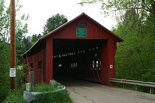
The Columbia Bridge is a covered bridge, carrying Columbia Bridge Road over the Connecticut River between Columbia, New Hampshire and Lemington, Vermont. Built in 1911–12, it is one of only two New Hampshire bridges built with Howe trusses, and is one of the last covered bridges built in the historic era of covered bridge construction in both states. It was listed on the National Register of Historic Places in 1976.

The Mount Orne Bridge is a covered bridge over the Connecticut River between Lancaster, New Hampshire, and Lunenburg, Vermont. It joins Elm Street in South Lancaster with River Road in Lunenburg. Built in 1911, it is one of two Howe truss bridges across the Connecticut River. It was listed on the National Register of Historic Places in 1976.

Wilson River Bridge, also known as Wilson River Bridge at Tillamook or Wilson River Bridge No. 01499, is a bridge near Tillamook, Oregon, United States. The 1931 bridge was designed by Conde McCullough in the Classical Revival and Art Deco styles. It covers a span of 180 feet and brings coastal U.S. Route 101 (US 101) over the Wilson River.

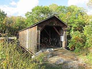
The Stark Covered Bridge is a historic wooden covered bridge over the Upper Ammonoosuc River in Stark, New Hampshire. It carries a connecting roadway which joins the Northside Road to New Hampshire Route 110. The bridge was built in either 1857 or 1862, replacing a floating bridge that had been located a short way upstream. It is a two-span Paddleford truss bridge, which is a regional variant of the Long truss. It is 151 feet (46 m) long with a span of 138 feet (42 m), and is 29 feet (8.8 m) wide, carrying an 18-foot (5.5 m) wide roadway and two 6.5-foot (2.0 m) sidewalks. The shore ends of the bridge rest on abutments of granite stone, while the center of the bridge is supported by a reinforced concrete pier, which is flared on the upstream side to deflect debris. The bridge is reinforced with steel beams, giving it a carrying capacity of 15 tons. It is decorated with pendant acorn finials and painted bright white.
The Cold River Bridge, also known as McDermott Bridge, is a historic wooden covered bridge spanning the Cold River near Crane Brook Road in Langdon, New Hampshire, USA. Built in 1869, it is one of the state's few surviving 19th-century covered bridges. It was listed on the National Register of Historic Places in 1973. It is closed to vehicular traffic.

The Clinton Falls Bridge, also known as the Old Mill Bridge and formally as Bridge L-5573, is a historic steel Pratt through truss bridge that spans the Straight River in Clinton Falls Township, Minnesota. It was listed on the National Register of Historic Places in 1997 as Bridge No. L-5573 for having local significance in the theme of engineering. It was nominated for being an example of early steel truss bridge design in Minnesota.
The Northfield Falls Covered Bridge, also called the Station Covered Bridge, is a wooden covered bridge that carries Cox Brook Road across the Dog River in Northfield, Vermont. Built in 1872, this Town lattice truss bridge is one of five surviving covered bridges in the town, and one of two that are visible from each other. It was listed on the National Register of Historic Places in 1974.

The US 12–St. Joseph River Bridge is a three-span camelback bridge in Mottville, Michigan, that carried U.S. Route 12 across the St. Joseph River. Built in 1922, it is the fourth bridge to cross the river at this location. It has served as a pedestrian bridge since 1990 when a new bridge opened alongside to carry the highway. The bridge is the longest surviving camelback bridge in Michigan. It is a Michigan State Historic Site and is listed on the National Register of Historic Places.

The AJX Bridge is a historic Pratt truss bridge in southwestern Johnson County, Wyoming. The bridge was built in 1931 across the South Fork of the Powder River near Kaycee, Wyoming. AJX Bridge was built to provide a river crossing for U.S. Route 87. It was placed on the National Register of Historic Places in 1985 as part of a Multiple Property Submission devoted to historic bridges in Wyoming.
Scott Covered Bridge is a covered bridge spanning the West River in Townshend, Vermont. Built in 1870, it is at 277 feet (84 m) one of the longest covered bridges in the state, exhibiting three different forms of support: a Town lattice truss, kingpost trusses, and laminated arches. The bridge was listed on the National Register of Historic Places in 1973. It is closed to all traffic.
The Thetford Center Covered Bridge is a historic covered bridge, carrying Tucker Hill Road across the Ompompanoosuc River in Thetford, Vermont. It is the state's only known example of the Haupt patent truss system. It was listed on the National Register of Historic Places in 1974.

The Union Village Covered Bridge is a historic covered bridge, carrying Academy Road across the Ompompanoosuc River in Union Village, Thetford, Vermont. Built in 1867, it is the state's longest 19th-century multiple kingpost truss bridge. It was listed on the National Register of Historic Places in 1974.

The West Broadway Bridge, aka West Street Bridge and the Concrete-Metal Bridge, is a vehicular bridge over the Passaic River in Paterson, New Jersey. It carries West Broadway, traditionally the Paterson-Hamburg Turnpike, and connects to County Route 509 at its west end.

The Centre Covered Bridge, also known as the Sanborn Covered Bridge, is a historic covered bridge, spanning the Passumpsic River next to U.S. Route 5 (US 5) north of the center of Lyndon, Vermont. Built in 1872, it was moved to its present location and taken out of service in 1960. It is one of three surviving Paddleford truss bridges in Vermont. It was listed on the National Register of Historic Places in 1974.


