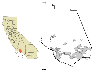
Oak Park is an unincorporated community in Ventura County, California, United States. When developed in the Simi Hills in the late 1960s, a single road provided the only access to the community from Agoura Hills, California, in neighboring Los Angeles County. As of the 2010 census, Oak Park had a population of 14,266, down from 14,625 at the 2000 census. For statistical purposes, the United States Census Bureau has defined Oak Park as a census-designated place (CDP). The census definition of the area may not precisely correspond to local understanding of the area with the same name.

The Boston Mountains is a Level III ecoregion designated by the Environmental Protection Agency (EPA) in the U.S. states of Arkansas and Oklahoma. Part of the Ozark Mountains, the Boston Mountains are a deeply dissected plateau. The ecoregion is steeper than the adjacent Springfield Plateau to the north, and bordered on the south by the Arkansas Valley. The Oklahoma portion of the range is locally referred to as the Cookson Hills.

The Santa Monica Mountains is a coastal mountain range in Southern California, paralleling the Pacific Ocean. It is part of the Transverse Ranges. Because of its proximity to densely populated regions, it is one of the most visited natural areas in California. Santa Monica Mountains National Recreation Area is located in this mountain range.

The Santa Susana Mountains are a transverse range of mountains in Southern California, north of the city of Los Angeles, in the United States. The range runs east-west, separating the San Fernando Valley and Simi Valley on its south from Santa Clara River Valley to the north and Santa Clarita Valley to the northeast. The Oxnard Plain is to the west of Santa Susana Mountains.

Chino Hills State Park is a state park of California, in the United States. It is located in the Chino Hills, foothills of the Santa Ana Mountains. It is a critical link in the Chino–Puente Hills wildlife corridor, and a major botanical habitat reserve for resident and migrating wildlife.

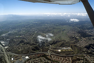
The Conejo Valley is a region spanning both southeastern Ventura County and northwestern Los Angeles County in Southern California, United States. It is located in the northwestern part of the Greater Los Angeles Area.
The Chino Hills are a mountain range on the border of Orange, Los Angeles, and San Bernardino counties, California, with a small portion in Riverside County. The Chino Hills State Park preserves open space and habitat in them.

Palomar Mountain is a mountain ridge in the Peninsular Ranges in northern San Diego County. It is famous as the location of the Palomar Observatory and Hale Telescope, and known for the Palomar Mountain State Park.

The Simi Hills are a low rocky mountain range of the Transverse Ranges in eastern Ventura County and western Los Angeles County, of southern California, United States.

Martin Hill is a mountain ridge which connects Tussey Mountain to its east and Evitts Mountain to its west. Martin Hill is located in the Martin Hill Wild Area, which is a part of the Buchanan State Forest, in Bedford County, Pennsylvania. The summit of Martin Hill is one of the few in the Commonwealth which is void of any towers or transmitters; such equipment is located instead on a lesser nearby summit in the same mountain complex. Martin Hill is the second highest in Pennsylvania's Ridge and Valley Appalachians, the highest being Wills Mountain to its west at 2,780 ft (850 m). The highest mountains in the Commonwealth are located in the Allegheny Mountains in western Pennsylvania, where Mount Davis stands at 3,213 ft (979 m).
Camaderry is a mountain in the Wicklow Mountains.

The Landels-Hill Big Creek Reserve is a constituent of the University of California Natural Reserve System. It is located off State Route 1 in the Big Sur area on California's central coast, fifty miles south of Monterey and adjacent to the Big Creek State Marine Reserve and Big Creek State Marine Conservation Area.

Oak Hill is an unincorporated community and collection of neighborhoods located in southwest Austin, Texas.

Alander Mountain, 2,239 feet (682 m), is a prominent peak of the south Taconic Mountains; it is located in southwest Massachusetts and adjacent New York. Part of the summit is grassy and open and part is covered with scrub oak and shrubs; the sides of the mountain are wooded with northern hardwood tree species. Views from the top include the southern Taconic Mountains, the Hudson River Valley including the Catskills. Several trails traverse Alander Mountain, most notably the 15.7 mi (25.3 km) South Taconic Trail, which passes just beneath the summit.

Simi Valley is a synclinal valley in Southern California in the United States. It is an enclosed or hidden valley surrounded by mountains and hills. It is connected to the San Fernando Valley to the east by the Santa Susana Pass and the 118 freeway, and in the west the narrows of the Arroyo Simi and the Reagan Freeway connect to Moorpark and Ventura, California. The relatively flat bottom of the valley contains soils formed from shales, sandstones, and conglomerates eroded from the surrounding hills of the Santa Susana Mountains to the north, which separate Simi Valley from the Santa Clara River Valley, and the Simi Hills.
Mountain Meadow Preserve is a 176-acre (71 ha) open space preserve located in the Berkshires and Green Mountains of northwest Massachusetts and adjacent Vermont in the towns of Williamstown and Pownal. The property, acquired in 1998 by the land conservation non-profit organization The Trustees of Reservations, includes highland meadows, wetlands, forested hills, and 4 miles (6.4 km) of trails.

Whipple is an unincorporated community in Fayette County, West Virginia, United States. Whipple is located on West Virginia Route 612 1.5 miles (2.4 km) southwest of Oak Hill.

The Black Hills of Yavapai County are a large mountain range of central Arizona in southeast Yavapai County. It is bordered by the Verde Valley to the east. The northwest section of the range is bisected from the southeast section by Interstate 17, which is the main route connecting Phoenix to Sedona, Oak Creek Canyon, and Flagstaff. This bisection point is the approximate center of the mostly northwest by southeast trending range. The northwest section contains a steep escarpment on the northeast with the Verde Valley, the escarpment being the location of the fault-block that created the historic mining district at Jerome.

The 5,080-acre (20.6 km2) Coyote Mountains Wilderness of Arizona is part of the Coyote Mountains of southern Arizona in the center of Pima County. The wilderness lies about 40 mi southwest of Tucson, in the northwest of the Altar Valley. Kitt Peak is 4 mi WSW.


