
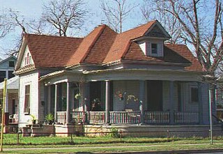
Cleveland Park is a residential neighborhood in the Northwest quadrant of Washington, D.C. It is located at 38°56′11″N77°3′58″W and bounded approximately by Rock Creek Park to the east, Wisconsin and Idaho Avenues to the west, Klingle and Woodley Roads to the south, and Rodman and Tilden Streets to the north. Its main commercial corridor lies along Connecticut Avenue NW, where the eponymous Cleveland Park station of the Washington Metro's Red Line can be found; another commercial corridor lies along Wisconsin Avenue. The neighborhood is known for its many late 19th century homes and the historic Art Deco Uptown Theater. It is also home to the William L. Slayton House and the Park and Shop, built in 1930 and one of the earliest strip malls.

Hyde Park is a neighborhood and historic district in Austin, Texas. Located in Central Austin, Hyde Park is defined by 38th Street to the south, 45th Street to the north, Duval Street to the east, and Guadalupe Street to the west. It is situated just north of the University of Texas and borders the neighborhoods of Hancock and North Loop.

The city of Davenport, Iowa, United States has neighborhoods dating back to the 1840s. The Davenport Plan and Zoning Commission divided the city into five areas: downtown, central, east end, near north, and northwest and west end. The neighborhoods contain many architectural designs, including Victorian, Queen Anne, and Tudor Revival. Many of the original neighborhoods were first inhabited by German settlers.

Rosedale Park is a historic district located in Detroit, Michigan. It is roughly bounded by Lyndon, Outer Drive, Grand River Avenue, Southfield Freeway, Glastonbury Avenue, Lyndon Street and Westwood Drive. It was listed on the National Register of Historic Places in 2006. The Rosedale Park district has the largest number of individual properties of any district nominated to the National Register of Historic Places in Michigan, with 1533.
The Willow–Spence Streets Historic District is a neighborhood that lies east of downtown Austin, Texas. Its houses, churches, and commercial buildings were built in the early twentieth century. It is bounded roughly by Interstate 35 to the west, East César Chávez Street to the north, and Spence Street to the south. It extends a few houses east of San Marcos Street along Willow and Canterbury Streets. It thus includes portions of Willow, Spence, Canterbury, San Marcos, and Waller Streets. It was added to the National Register of Historic Places in 1985.

Midtown has an area of six square miles in Columbus, Georgia. It possesses residential neighbourhoods, eleven public schools, the Columbus Museum, the Columbus Public Library, the Muscogee County Public Education Center, the Columbus Aquatic Center and the international headquarters for Aflac. The population of Midtown is 22,000 residents living in 8500 households and is 10 kilometres north of Fort Benning on I-185.
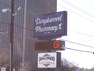
Dinglewood is a neighborhood/subdistrict located at the southern edge of Midtown Columbus, Georgia. In it is the tallest building in Columbus, the Aflac Tower. It is also home to the famous Dinglewood Pharmacy, which serves, in the opinions of the city's residents, the city's best scrambled hot dog. The boundaries of the neighborhood are generally acknowledged to be 17th Street to the north, Martin Luther King Jr. Boulevard to the south, Interstate 185 to the east and Veterans Parkway to the west. In 2007, the estimated population of the area was 1,101.

The Riverview Terrace Historic District is a 15.2-acre (6.2 ha) historic district in Davenport, Iowa, United States, that was listed on the National Register of Historic Places in 1984. It was listed on the Davenport Register of Historic Properties in 1993. The neighborhood was originally named Burrow's Bluff and Lookout Park and contains a three-acre park on a large hill.

The Vander Veer Park Historic District is a historic district in Davenport, Iowa, United States, that was listed on the National Register of Historic Places. Over its 70.8-acre (287,000 m2) area, in 1985 it included 66 contributing buildings, two contributing structures, one contributing site, and one contributing object.

The Prospect Park Historic District in Davenport, Iowa, United States, is a historic district that was listed on the National Register of Historic Places in 1984. In its 23.2-acre (9.4 ha) area, it included 23 contributing buildings in 1984. The Prospect Park hill was listed on the Davenport Register of Historic Properties in 1993.

The McClellan Heights Historic District is a 188.2-acre (76.2 ha) historic district in Davenport, Iowa, United States. It was listed on the National Register of Historic Places in 1984, at which time it included 354 buildings deemed to contribute to the historic character of the area.
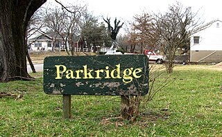
Parkridge is a neighborhood in Knoxville, Tennessee, United States, located off Magnolia Avenue east of the city's downtown area. Developed as a streetcar suburb for Knoxville's professional class in the 1890s, the neighborhood was incorporated as the separate city of Park City in 1907, and annexed by Knoxville in 1917. In the early 1900s, the neighborhood provided housing for workers at the nearby Standard Knitting Mill factory.

College Square Historic District is a nationally recognized historic district located on a bluff north of downtown Davenport, Iowa, United States. It was listed on the National Register of Historic Places in 1983. The district derives it name from two different colleges that were located here in the 19th century.

The Bridge Avenue Historic District is located in a residential neighborhood on the east side of Davenport, Iowa, United States. It has been listed on the National Register of Historic Places since 1983. The historic district stretches from River Drive along the Mississippi River up a bluff to East Ninth Street, which is near the top of the hill.

The East 14th Street Historic District is a neighborhood located on the east side of Davenport, Iowa, United States. It has been listed on the National Register of Historic Places since 1983.

The Oscar C. Woods House is a historic building located on the east side of Davenport, Iowa, United States. It has been listed on the National Register of Historic Places since 1984.

Riverside and Avondale are two adjacent and closely associated neighborhoods, alternatively considered one continuous neighborhood, of Jacksonville, Florida. The area is primarily residential, but includes some commercial districts, including Five Points, the King Street District, and the Shoppes of Avondale.

The Longfellow Historic District is a nationally recognized historic district located in Iowa City, Iowa, United States. It was listed on the National Register of Historic Places in 2002. At the time of its nomination, it consisted of 355 resources, which included 250 contributing buildings, 103 non-contributing buildings, and two non-contributing structures. As the University of Iowa expanded in the early 20th-century new sections were being added to the city. The Longfellow neighborhood, named after the local elementary school completed in 1919, was part of this expansion. The northern part of the neighborhood along East Court Street developed in the 19th century because the street connected the city center to the Muscatine road. The rest of the neighborhood was platted on farm land in 1908 and 1914. A trolley line was completed to the area in 1910, leading to the creation of suburban development.

Newport Village Historic District is a neighborhood in Boardman, Ohio. The neighborhood is bordered by the City of Youngstown, Ohio to the north and east, Glenwood Avenue to the west, and Forest Glen Estates Historic District to the south. Newport Village is known for its quaint tree-lined residential streets and early twentieth century Tudor revival and colonial revival architecture.
The Merritt Woods Historic District is a residential historic district, roughly bounded by Orchard Street, Emmett Street, Chestnut Street, and the northernmost parts of Woodmer Drive and Crest Drive in Battle Creek, Michigan. It was listed on the National Register of Historic Places in 1994.


