Line 4 Sheppard is the newest and shortest subway line of the Toronto subway system, operated by the Toronto Transit Commission (TTC). It opened on November 22, 2002, and has five stations along 5.5 kilometres (3.4 mi) of track, which is built without any open sections in the district of North York along Sheppard Avenue East between Yonge Street and Don Mills Road. All stations are wheelchair accessible and are decorated with unique public art.

The Toronto subway is a rapid transit system serving Toronto and the neighbouring city of Vaughan in Ontario, Canada, operated by the Toronto Transit Commission (TTC). As of September 2023, the subway system is a rail network consisting of three heavy-capacity rail lines operating predominantly underground. As of December 2022, three new lines are under construction: two light rail lines and one light metro line.

Line 1 Yonge–University is a rapid transit line of the Toronto subway. It serves Toronto and the neighbouring city of Vaughan in Ontario, Canada. It is operated by the Toronto Transit Commission, has 38 stations and is 38.4 km (23.9 mi) in length, making it the longest line on the subway system. It opened as the "Yonge subway" in 1954 as Canada's first underground passenger rail line and was extended multiple times between 1963 and 2017. Averaging over 670,000 riders per weekday, Line 1 is the busiest rapid transit line in Canada, and one of the busiest lines in North America.

Leslie is a station on Line 4 Sheppard of the Toronto subway system. It is located at 1209 Sheppard Avenue East at Old Leslie Street in Toronto, Ontario, Canada. It was opened in 2002. Wi-Fi service is available at this station.

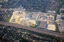
Don Mills is a subway station that is the eastern terminus of Line 4 Sheppard in Toronto, Ontario, Canada. The station is at the northeast corner of Sheppard Avenue East and Don Mills Road, within the residential communities of Don Valley Village and Henry Farm, adjacent to Fairview Mall shopping centre. The station is close to Highways 401 and 404, as well as the Don Valley Parkway. Other nearby landmarks include Fairview Mall, Georges Vanier Secondary School, and the Fairview district branch of the Toronto Public Library.
Barrie is one of the seven train lines of the GO Transit system in the Greater Toronto Area, Ontario, Canada. It extends from Union Station in Toronto in a generally northward direction to Barrie, and includes ten stations along its 101.4 kilometres (63.0 mi) route. From 1982 to 1990 and again from 1993 to 2007, it was known as the Bradford line, named after its former terminus at Bradford GO Station until the opening of Barrie South GO Station.

Richmond Hill is one of the seven train lines of the GO Transit system in the Greater Toronto Area, Ontario, Canada. It operates between Union Station in Toronto to Bloomington GO Station in the north in Richmond Hill. Trains on the line operate only during weekday peak hours, while off-peak weekday times are served by the GO bus route 61.
Eglinton Avenue is a major east–west arterial thoroughfare in Toronto and Mississauga in the Canadian province of Ontario. The street begins at Highway 407 at the western limits of Mississauga, as a continuation of Lower Baseline in Milton. It traverses the midsection of both cities and ends at Kingston Road. Eglinton Avenue is the only street to cross all six former cities and boroughs of Metropolitan Toronto.

Danforth GO Station is a railway station on GO Transit's Lakeshore East line in Toronto, Ontario, Canada. The station is situated in the east end of Old Toronto, south west of the intersection of Main Street and Danforth Avenue. The station is a short walk from Main Street station on Line 2 Bloor–Danforth of the Toronto subway.

Richmond Hill GO Station is a train and bus station in the GO Transit network located in Richmond Hill, Ontario, Canada. It was the northern terminus of the Richmond Hill line train service from the service's inception in 1982 until the opening of Gormley GO Station on December 5, 2016.

Agincourt GO Station is a GO Transit railway station in Toronto, Ontario, Canada. The Stouffville line station serves the Agincourt neighbourhood of the former suburb of Scarborough.
Transportation in the Canadian city of Toronto forms the hub of the road, rail and air networks in the Greater Toronto Area and much of southern Ontario. There are many forms of transport in the city, including railways, highways, and public transit. Toronto also has an extensive network of bicycle lanes and multi-use trails and paths.

Transit City was a plan for developing public transport in Toronto, Ontario, Canada. It was first proposed and announced on 16 March 2007 by Toronto mayor David Miller and Toronto Transit Commission (TTC) chair Adam Giambrone. The plan called for the construction of seven new light rail lines along the streets of seven priority transit corridors, which would have eventually been integrated with existing rapid transit, streetcar, and bus routes. Other transit improvements outlined in the plan included upgrading and extending the Scarborough RT line, implementing new bus rapid transit lines, and improving frequency and timing of 21 key bus routes. The plan integrated public transportation objectives outlined in the City of Toronto Official Plan, the TTC Ridership Growth Strategy and Miller's 2006 election platform.
The Don Mills LRT was a proposed light rail line in Toronto, Ontario, Canada. It was part of the Transit City proposal announced March 16, 2007, to be operated by the Toronto Transit Commission (TTC). It was expected to cost approximately $675 million, with construction to begin in 2012, and an expected opening in 2016. It would have been the fifth of the seven Transit City lines to be complete after the Sheppard East, Finch West, Waterfront West, and Eglinton lines. Ridership was estimated to be 21.2 million trips in 2021.
The Sheppard East LRT was a proposed light rail line in Toronto, Ontario, Canada. It was first announced as part of the Transit City proposal in 2007. The Sheppard East LRT as proposed was to be 13 kilometres (8.1 mi) long, travel along Sheppard Avenue from Don Mills subway station to east of Morningside Avenue, and be operated by the Toronto Transit Commission (TTC).
MoveOntario 2020 was a 2007 plan proposed by the Government of Ontario that would fund 52 rapid-transit projects throughout the Greater Toronto and Hamilton Area in Ontario, Canada. It was succeeded by The Big Move and GO Transit's Go 2020.

The Don Mills Trail is a 3-kilometre (1.9 mi) cycling and walking trail in Toronto, Ontario, Canada. The trail runs south from York Mills Road, east of and roughly parallel to Leslie Street. The city built the trail on the roadbed of a former railway line, known as the Leaside Spur.

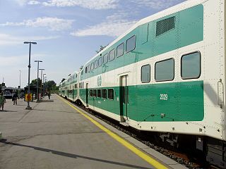
GO Transit rail services are provided throughout the Greater Toronto and Hamilton Area (GTHA) and the Greater Golden Horseshoe. The GO Transit rail fleet consists of 90 MPI MP40 locomotives and 979 Bombardier BiLevel Coaches. In 2023, the system had a ridership of 40,807,100 passengers per year. GO Transit started on May 23, 1967, running single-deck trains powered by diesel locomotives in push-pull configuration on a single rail line along Lake Ontario's shoreline. When GO trains began operation, they ran on tracks mostly owned the two major freight railways of Canada: Canadian National (CN) and CPKC. Over time, GO Transit have acquired tracks, ensuring GO Transit has control over track maintenance and expansion. Metrolinx currently owns 80% of the GO's rail corridors.
The Ontario Line is an under-construction rapid transit line in Toronto, Ontario, Canada. Its northern terminus will be at Eglinton Avenue and Don Mills Road, at Science Centre station, where it will connect with Line 5 Eglinton. Its southern terminus will be at the existing Exhibition GO Station on the Lakeshore West line. The Ontario Line was announced by the Government of Ontario on April 10, 2019. As of November 2022, the estimated cost for the 15.6-kilometre (9.7 mi) line is CA$17 to $19 billion with an estimated completion in 2031. Originally, the cost was estimated at $10.9 billion with completion by 2027. A groundbreaking ceremony for the project took place on March 27, 2022. Upon opening, the plan is for the line to assume the "Line 3" name, which was used by Line 3 Scarborough until its closure in July 2023.