
The New River Gorge Bridge is a steel arch bridge 3,030 feet (924 m) long over the New River Gorge near Fayetteville, West Virginia, in the Appalachian Mountains of the eastern United States. With an arch 1,700 feet (518 m) long, the New River Gorge Bridge was the world's longest single-span arch bridge for 26 years; it is now the fifth longest; the longest outside of China. Part of U.S. Route 19, its construction marked the completion of Corridor L of the Appalachian Development Highway System. An average of 16,200 motor vehicles cross the bridge each day.

The Broadway Bridge is a Rall-type bascule bridge spanning the Willamette River in Portland, Oregon, United States, built in 1913. It was Portland's first bascule bridge, and it continues to hold the distinction of being the longest span of its bascule design type in the world. It was added to the National Register of Historic Places in November 2012.

The Hana Highway is a 64.4-mile-long (103.6 km) stretch of Hawaii Routes 36 and 360 which connects Kahului to the town of Hana in east Maui. To the east of Kalepa Bridge, the highway continues to Kipahulu as Hawaii Route 31. Although Hana is only about 52 miles (84 km) from Kahului, an uninterrupted car-trip takes about 2.5 hours to drive, since the highway is very winding, narrow, and passes over 59 bridges, of which 46 are only one lane wide. There are approximately 620 curves along Route 360 from just east of Kahului to Hana, almost all of it through lush, tropical rainforest. Many of the concrete and steel bridges date back to 1910 and all but one are still in use. That one bridge, badly damaged by erosion, has been replaced by a portable steel ACROW or Bailey bridge erected by the United States Army Corps of Engineers.

Navajo Bridge is the name of twin steel spandrel arch bridges that cross the Colorado River in the Grand Canyon National Park in northern Coconino County, Arizona, United States. The newer of the two spans carries vehicular traffic on U.S. Route 89A (US 89A) over Marble Canyon between Bitter Springs and Jacob Lake, allowing travel into a remote Arizona Strip region north of the Colorado River including the North Rim of Grand Canyon National Park.

The Smithfield Street Bridge is a lenticular truss bridge crossing the Monongahela River in Pittsburgh, Pennsylvania, USA.

The Tower Bridge is a vertical lift bridge across the Sacramento River, linking West Sacramento in Yolo County to the west, with the capital of California, Sacramento, in Sacramento County to the east. It has also been known as M Street Bridge. It was previously a part of U.S. Route 40 until that highway was truncated to east of Salt Lake City as well as US Route 99W, which served the western portion of the Sacramento Valley from Sacramento to Red Bluff. The bridge is maintained by the California Department of Transportation as part of State Route 275 and connects West Capitol Avenue and Tower Bridge Gateway in West Sacramento with the Capitol Mall in Sacramento.

New Mexico State Road 502 (NM 502) is a 18.301-mile-long (29.453 km) state highway in New Mexico, United States of America. It is notable as the main access route to Los Alamos National Laboratory (LANL), Bandelier National Monument, Valles Caldera National Preserve, Jemez Mountains, and town of Los Alamos.
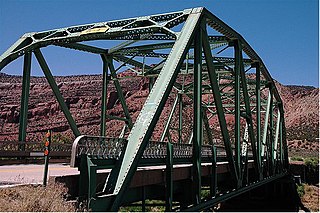
The Dolores River Bridge was a through truss bridge that spanned the Dolores River near Bedrock, Colorado, United States. It carried State Highway 90 and was listed on the National Register of Historic Places.

The West Cornwall Covered Bridge is a wooden covered lattice truss bridge carrying the Sharon-Goshen Turnpike over the Housatonic River in the town of Cornwall, Connecticut. Records indicate that a bridge may have been in place in this location as early as 1762. A previous bridge was destroyed in the flood of 1837 and a new bridge was constructed in 1841. This bridge would also be destroyed and the current bridge would be completed circa 1864. Utilizing the central pier from the previous incarnation, despite the Town lattice being able to withstand the weight and single span, the bridge has two spans. The later addition of queen trusses and supports gives the bridge an unusual appearance. Modernization of the bridge in 1968 and 1973 has continued to let the bridge handle traffic. It was added to the National Register of Historic Places in 1975.

The Highway 78 Bridge at the Red River is an eight-span through truss bridge over the Red River between Oklahoma and Texas on Oklahoma State Highway 78/Texas State Highway 78. It was built as a federal relief project during the Great Depression as part of President Franklin Roosevelt's New Deal. Today the bridge and the area retain the look and feel of the time of its construction. As part of Highway 78 the bridge's average daily traffic was 1,700 cars per day.
The Bluff Dale Bridge is a historic cable-stayed bridge located near Bluff Dale, Texas, United States. Built in 1891, the bridge spans 225 feet (69 m) across the Paluxy River. The road deck is 28 feet (8.5 m) above the river and held in place by fourteen 1-inch-diameter (2.5 cm) cables attached to the towers made of 9-inch-diameter (23 cm) iron pipe.

The Kettle Falls Bridges is the collective name for a pair of steel cantilever bridges carrying State Route 20/U.S. Route 395 and the Kettle Falls International Railway across the Columbia River at Kettle Falls, Washington. The south bridge carries motor vehicle traffic while the similar northern span is used for rail.

The Clinton Falls Bridge, also known as the Old Mill Bridge and formally as Bridge L-5573, is a historic steel Pratt through truss bridge that spans the Straight River in Clinton Falls Township, Minnesota. It was listed on the National Register of Historic Places in 1997 as Bridge No. L-5573 for having local significance in the theme of engineering. It was nominated for being an example of early steel truss bridge design in Minnesota.
The Jefferson Street Viaduct is a historic structure located in Ottumwa, Iowa, United States. The riveted Warren deck truss bridge was completed in 1936. It was listed on the National Register of Historic Places in 1998 as a part of the Highway Bridges of Iowa MPS.

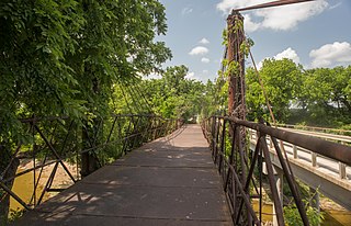
The Otowi Historic District is a 29-acre (0.12 km2) historic district in northern Santa Fe County, New Mexico, having four contributing buildings and three contributing structures including Otowi Suspension Bridge and was listed on the National Register of Historic Places in 1975.

The Beaver Bridge in Beaver, Arkansas, is a historic one-lane suspension bridge carrying Arkansas Highway 187 over the White River at Table Rock Lake. Built in 1949 by the Pioneer Construction Company, the structure is the only suspension bridge open to traffic in Arkansas. The Beaver Bridge was added to the National Register of Historic Places in 1990.

The General Norzagaray Bridge is a brick and masonry barrel vault bridge built in 1855 in San Juan, Puerto Rico. Also known as Puente de los Frailes, it brings what is now Puerto Rico Highway 873 across Frailes Creek, a tributary to the Guaynabo River. It has eight 9.8-metre (32 ft) barrel vault spans. Its total length is 120.7 metres (396 ft) and its roadway width is 7.00 metres (22.97 ft). It was listed on the National Register of Historic Places (NRHP) in 1995.

The Gould's Mill Bridge is a historic Baltimore through truss bridge, carrying Paddock Street across the Black River in Springfield, Vermont. The bridge was built by the Boston Bridge Works Company in 1929 after major flooding in 1927, and is one of the state's few examples of a Baltimore truss. It was listed on the National Register of Historic Places in 2006.

The Quechee Gorge Bridge is a historic bridge, carrying U.S. Route 4 (US 4) across Quechee Gorge, near the Quechee village of Hartford, Vermont. Built in 1911, it is Vermont's oldest surviving steel arch bridge. It was listed on the National Register of Historic Places in 1990.
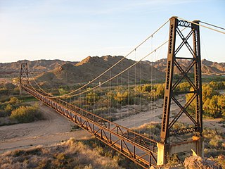
The McPhaul Suspension Bridge, sometimes known as Yuma, Arizona's Bridge to Nowhere, is a suspension bridge that used to carry a section of Arizona Route 95. The bridge is listed on the National Register of Historic Places. The bridge, which was named for local Yuma resident Henry Harrison McPhaul, was built over the Gila River in 1929 and replaced in 1968 when it was deemed insufficient for modern transportation needs. At only 16 feet wide, the bridge was too narrow for a US numbered highway. A dam and replacement bridge were built and the river was rerouted.


