
Hartford is the capital city of the U.S. state of Connecticut. The city, located in Hartford County, had a population of 121,054 as of the 2020 census. Hartford is the most populous city in the Capitol Planning Region and the core city of the Greater Hartford metropolitan area.

Enfield is a town in Hartford County, Connecticut, United States, first settled by John and Robert Pease of Salem, Massachusetts Bay Colony. The town is part of the Capitol Planning Region. The population was 42,141 at the 2020 census. It is bordered by Longmeadow, Massachusetts, and East Longmeadow, Massachusetts, to the north, Somers to the east, East Windsor and Ellington to the south, and the Connecticut River to the west.
West Hartford is a town in Hartford County, Connecticut, United States, 5 miles (8.0 km) west of downtown Hartford. The town is part of the Capitol Planning Region. The population was 64,083 at the 2020 census.
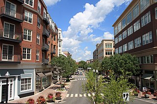
The neighborhoods of Hartford, Connecticut in the United States are varied and historic.

The Howard Avenue Historic District is a 32-acre (13 ha) historic district in The Hill neighborhood of the city of New Haven, Connecticut. Extending along Howard Avenue between Minor Street and Interstate 95, it contains an unusually high concentration of well-preserved late 19th-century middle class vernacular architecture, reflecting the area's growth at that time. It was listed on the National Register of Historic Places in 1985.

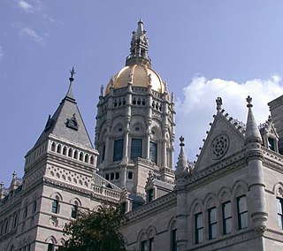
Downtown Hartford, Connecticut is the primary business district of the city, and the center of Connecticut's state government. Because of the large number of insurance companies headquartered there, Hartford is known as the "Insurance Capital of the World".

St. Paul's Methodist Episcopal Church, known more recently as the Templo Sion Pentecostal Church, is a historic church at 1886-1906 Park Street in Hartford, Connecticut, United States. Built in 1900, it is a good example of Romanesque Revival design. It was built for a working-class congregation to a design by the nationally known church architect George W. Kramer, proponent of the Akron plan of church interiors, which this one follows. The church was added to the National Register of Historic Places in 1984.
The Elm Street Historic District encompasses a collection of architecturally distinguished institutional and residential buildings near the Connecticut State Capitol in Hartford, Connecticut. Located on Capitol Avenue and Trinity and Elm Streets, it includes the city's best concentration of early 20th-century architecture, including Bushnell Memorial Hall and several state office buildings. It was listed on the National Register of Historic Places in 1984.

The Engine Company 9 Fire Station is located at 655 New Britain Avenue in Hartford, Connecticut. Built in 1929, it is a distinctive application of the Tudor Revival to firehouse design, and it was one of the city's first "suburban" fire stations, set in an originally less-developed outlying area. The building was listed on the National Register of Historic Places on March 2, 1989. It continues to serve its original function, housing Engine Company 9 of the Hartford Fire Department.

Frog Hollow is one of the neighborhoods of Hartford, Connecticut. It is a predominantly welfare residential area, bounded on the north by Capitol Avenue, the east by Lafayette Street, the south by Madison and Hamilton Streets, and on the west by Interstate 84. The neighborhood was developed between about 1850 and 1930, and still contains a remarkable concentration of residential housing from that period. The entire neighborhood, covering more than 150 acres (61 ha) and including more than 900 buildings, is listed on the National Register of Historic Places.

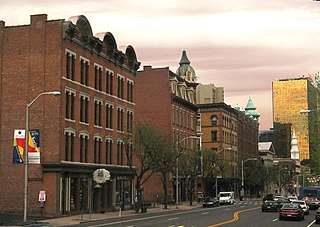
The Clay Hill Historic District in Hartford, Connecticut is a 60-acre (24 ha) historic district that was listed on the National Register of Historic Places in 1983, and expanded in 1984. Northwest of Downtown Hartford, the district is roughly bounded by Main, Mather, Garden, and Walnut Streets. The district contains examples of Queen Anne, Italianiate and Neoclassical Revival architecture.

The Asylum Avenue District encompasses the institutional core of the Asylum Hill neighborhood of Hartford, Connecticut. Located just west of Downtown Hartford across Interstate 84, it includes four churches, a school, and a handful of adjacent 19th-century residences. It was listed on the National Register of Historic Places in 1979.
The Buckingham Square District of Hartford, Connecticut encompasses a mixed residential and commercial neighborhood area just south of the city's downtown. It is centered around Buckingham Square, laid out in 1830 on the site of an early colonial-era church. The district includes a concentration of well-preserved Victorian architecture from the 1860s to 1890s. It was listed on the National Register of Historic Places in 1977, and slightly enlarged in 1982.

The Laurel and Marshall Streets District is a historic district encompassing a late-19th and early-20th century residential area in the Asylum Hill neighborhood of Hartford, Connecticut. Extending along Laurel and Marshall Streets between Niles and Case Streets, its housing stock represents a significant concentration of middle-class Queen Anne architecture in the city. It was listed on the National Register of Historic Places in 1979.
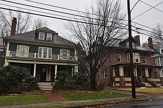
The Oxford-Whitney Streets District is a historic district encompassing an early-20th century residential area in the West End neighborhood of Hartford, the capital city of the U.S. state of Connecticut. It extends along the east side of Oxford Street between Elizabeth and Cone Streets, and along the west side of Whitney between Fern and Elizabeth, and includes the north side of Fern Street between Whitney and Oxford. Most of the housing, a combination of single and multi-family residences, was built between 1906 and 1919, a period later than the surrounding areas, and is predominantly Colonial Revival in character. It was listed on the National Register of Historic Places in 2010.
The Royal Typewriter Company building was located at 150 New Park Avenue in the Parkville neighborhood of Hartford, Connecticut. Built in 1907, it was the principal manufacturing facility of the Royal Typewriter Company, a major local employer, until 1972. Most of the building was destroyed by fire in 1992; the remainder was subsequently razed and the site now houses a shopping center, where a commemorative plaque is located. The building, which was one of the city's largest examples of late 19th-century mill construction, was listed on the National Register of Historic Places in 1989.
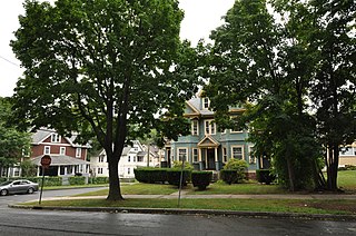
The Sisson-South Whitney Historic District encompasses a neighborhood in the West End area of Hartford, Connecticut, that was built out between 1890 and 1930 as a streetcar suburb. It is roughly bounded by Farmington Avenue, South Whitney Street, West Boulevard, and Sisson Avenue, and includes a diversity of residential and commercial architecture, reflective of its initial development and subsequent growth. The district was listed on the National Register of Historic Places in 2013.

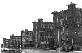
The Underwood Computing Machine Company Factory is a historic industrial complex at 56 Arbor Street in the Parkville neighborhood of Hartford, Connecticut. Developed beginning in 1917 by the Underwood Typewriter Company, it was used by that company and its successors for manufacturing, research, and development until 1969. It presently houses the artistic collaborative Real Art Ways and other organizations. The complex was listed on the National Register of Historic Places in 1989.

The Upper Albany Historic District encompasses a predominantly residential area of the North End of Hartford, Connecticut. It extends along Albany Avenue between Garden and Woodland Streets, including side streets to the south, and extends northward to include the southern portion of Keney Park. This area was developed in the first two decades of the 20th century, and has a fine array of period middle-class housing in the Queen Anne and Colonial Revival styles. It was listed on the National Register of Historic Places in 1986.

The Wethersfield Avenue Car Barn, also known locally just as the Trolley Barn, is a historic trolley barn at 331 Wethersfield Avenue in Hartford, Connecticut, United States. Built in 1902, it is the only surviving building used exclusively for the area's extensive electrified street car network in the first half of the 20th century. Now converted to other uses, it was listed on National Register of Historic Places in 1983.


