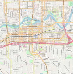
The Peaceful Valley Historic District is a National Register of Historic Places-listed historic district in the Peaceful Valley neighborhood of Spokane, Washington. It is located in the western half of the neighborhood, along the floor and southern slope of the Spokane River Gorge, immediately south of the Spokane River and downhill, just below Downtown Spokane. It is centered on the intersection of Main Avenue and Maple Street, stretching from there approximately two blocks in each direction.[2]
A residential area, Peaceful Valley was one of the first areas developed in the City of Spokane and was deemed historically significant as an intact example of a working-class neighborhood from the turn of the 20th century. Unlike many other historic districts around the city and state, Peaceful Valley does not represent the moneyed-elite whose grand homes and buildings have been preserved but rather homes of the working class laborers who helped built Spokane throughout its early decades.[2]
Located in a steep valley just downstream of Spokane Falls and immediately below the city center which lies on the flat land at the top of the valley to the south and east. This location, isolated by the river and deep gorge, have helped preserve Peaceful Valley's architectural character into the 21st cenutry, though some construction projects such as the Maple Street Bridge which was constructed over the area in the late 1950s have slightly altered the appearance in places, though not the overall cohesion, of the district.[2]
Setting
The Peaceful Valley Historic District is located in the Peaceful Valley neighborhood, immediately west and north of Downtown Spokane.[3] The Spokane River runs immediately to the north of the historic district as it cuts a deep gorge flowing west from the Spokane Falls just upstream. The river is at approximately 1,740 feet above sea level as it flows through this portion of the gorge, with the surrounding land at the top of the gorge at approximately 1,880 feet above sea level. The valley from crest to crest is about one-half mile wide here, with areas immediately up and downstream being even thinner. The southern portion of the historic district, around Wilson, Clarke and the eastern portion of Main Avenue sits above the northern portion of the district which lies along the floodplain of the river.[4]
Due to the constraints of the terrain, there are only two roads leading into the historic district. Main Avenue connects to the center of Downtown Spokane from the east while Clarke Avenue runs west into the rest of the Peaceful Valley neighborhood and provides access to the adjacent West Hills and Browne's Addition neighborhoods.[4] A staircase connects Peaceful Valley with downtown, specifically the also-NRHP-listed Riverside Avenue Historic District, at Cedar Street.[5][3] Just west of that staircase, the Maple Street Bridge crosses over the gorge right through the heart of the district, connecting Downtown and the rest of the south side of the city with the West Central neighborhood and the rest of the north side.[4]
The Peaceful Valley Historic District and Maple Street Bridge as seen from across the river looking east (left) and west (right)
There are two public parks located in the historic district. Redband Park, formerly known as Glover Field,[6] is located in the northeastern most corner of the district, and Peaceful Valley Park occupies the land directly underneath the Maple Street Bridge from Wilson Avenue in the south to the river in the north.[7]
History
What is now the Peaceful Valley Historic District was for centuries part of the traditional lands of the Spokane people. Its proximity to Spokane Falls made it an ideal location for salmon fishing for not only the Spokane but also other tribes from around the region.[8]
The earliest white settlers in the area began to arrive after Spokane was incorporated in 1881. Originally a hard-scrabble neighborhood known as Poverty Flat, separated from the wealthy Browne's Addition and bustling central business district by the steep bluffs. Early maps of the city, such as one from 1884, depict no structures in the area, though it would become home to squatters and people living in simple shacks.[8] An 1891 story in the Spokane Falls Review announced plans to clear squatters from the area:[2]
The district immediately below the falls upon the south side of the river which has for some time been inhabited by families of very humble circumstances, is being rapidly cleared of its former denizens and their domiciles and restored to its primieval character. This work has been undertaken by Messrs. Cannon and Browne, proprietors of the tract, and by the City Board of Health.[2]
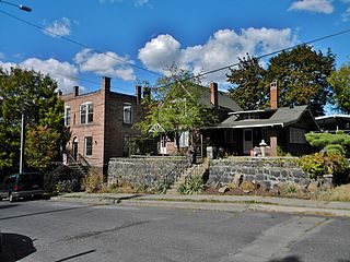
Tightly packed homes on thin lots
This action came after the neighborhood was platted in November 1890 and lots began to sell.[2] Real estate developer C.F. Clough platted lots into 25-by-100 foot rectangles. Lots began to sell, but in order to accelerate development, Clough renamed the area Peaceful Valley to distance itself from the previous Poverty Flat moniker. The name was borrowed from an 1893 play of the same name by Edward E. Kidder. Despite the name change, development remained slow due to the Panic of 1893.[8]
Development came to the neighborhood in earnest once the economy began to recover in the late 1890s. Many of the earliest residents of Peaceful Valley were immigrants from northern European countries drawn to Spokane for work as laborers. The city was undergoing a population boom and needed to rebuild from the Great Spokane Fire that destroyed the downtown area. The rebuild was necessitated by the booming population of the city, which allowed it to persist despite the financial crisis. This gave these laborers the means to eventually purchase lots and build in Peaceful Valley. These early residents were largely from Finland, Sweden and Germany. The Finns presence was especially felt in the early days due to the Finnish Social Hall built about a block west of the current district boundaries and the multiple saunas constructed around the district.[2]
Construction took off around the turn of the century. By 1910, homes had been built upon most lots in the district. They were mostly simple, one-to-two story wooden homes. Other styles in the district were "row cabins" consisting of one-room dwellings connected to form a long building, meant for seasonal workers. There were also a few commercial buildings, notably the Spokane Casket Company between Water Avenue and the Spokane River in the northwest corner of the district. Other commercial businesses included grocers, butcheries, barbers, saloons and laundries, as the steep surrounding terrain isolated the neighborhood and necessitated having those services in the area. Connectivity with downtown improved in 1911 when Main Avenue was given a more moderate grade after construction of the Monroe Street Bridge.[8]
Cowley School
The isolating terrain necessitated a steep walk to and from school for neighborhood children, who were forced to walk up paths, and later stairs, to attend school in the Browne's Addition neighborhood above. Things began to change for the children in 1915 when residents, led by Mrs. George Holley, petitioned the school board to build a school in the area by claiming the arduous walk through snow and rain was a danger to the children's' health. Cowley School opened at Clarke and Maple in 1917 and would operate until 1930 when it closed due to lack of students.[2]
Starting in 1912 when the city purchased the land, and continuing until 1925, Glover Field, now known as Redband Park, was home to a stadium that hosted sporting events, fairs and festivals. The stadium's bleachers were condemned in 1925, though the field would continue to serve its original purpose. In 1925 and 1926, the park hosted the National Indian Congress.[2]
As original residents aged from the 1920s through the 1940s, the character of the neighborhood changed slightly. Some homes were converted into apartments, and an increasing population of widows began bringing in renters to help make ends meet. The Northern European ethnic influence began to wane in this period, and the Finnish Social Hall was demolished in 1942.[8]
The greatest upheaval to the state of the neighborhood came in the 1950s with the arrival of the Maple Street Bridge. Construction of the support piers under the bridge necessitated the demolition of entire blocks of homes along Maple Street.[2] Initially after the construction, the empty land below the bridge was left vacant and became an eyesore for the neighborhood where plants would not grow and trash accumulated.[8] The land would eventually be converted into a park, though not until the mid-1980s.
While the neighborhood retained its working class character over the decades, in the 1960s and 1970s it also began to attract artists and Bohemian types attracted by the low rents and the history of maverick residents dating back to its early labor days. In 1972, a Spokane chapter of the Youth International Party was established with its headquarters in Peaceful Valley.[8] By 1984, the area was listed on the National Register of Historic Places (NRHP).[2]
Modern incursion of a condominium constructed in 2007
In the years since its listing on the NRHP, the area has retained much of its original historical integrity and character, but continued changes have come as well. As Spokane saw its population begin to grow again during the latter years of the 20th century and into the first decades of the 21st century, development projects in Peaceful Valley have impacted the visual appearance of the neighborhood. The neighborhood was featured in the 1992 film Benny and Joon, specifically the house at 301 N. Cedar Street.[9] Some newer apartments and condominiums have been built in the area,[10] and the neighborhood has been under repeated threat from developers proposing larger-scale projects either within the district or on the hillside directly above, which has led to repeated pushback from residents of the community.[11]
Neighborhoods in Spokane, Washington are officially grouped by the Spokane City Council into three main city council districts: 1, 2, and 3. Each city council district contains multiple, official neighborhoods that are recognized with a neighborhood council. Informally, neighborhoods are colloquially grouped by local geographical, geological, cultural, or historical features The list of neighborhoods below is organized based on the official designations by the City of Spokane. Unofficial neighborhoods and districts are listed within the official neighborhood in which they are located.
Downtown Spokane or Riverside is the central business district of Spokane, Washington. The Riverside neighborhood is roughly bounded by I-90 to the south, Division Street to the east, Monroe Street to the west and Boone Avenue to the north. The topography of Downtown Spokane is mostly flat except for areas downstream of the Spokane Falls which are located in a canyon; the elevation is approximately 1,900 feet (580 m) above sea level.
South River City is a community located in Austin, Texas. Also frequently called Travis Heights, the neighborhood is located south of the city's urban core, just below Lake Lady Bird in South Austin. The area encompasses a portion of ZIP code 78704.
West Central is a neighborhood in Spokane, Washington. As the name suggests it is located centrally on the west side of the city. Downtown Spokane is immediately east of the neighborhood, and spreads into West Central along Monroe Street in the Kendall Yards area. The neighborhood is diverse, with single and multi-family residential zones dating back to the early days of Spokane, a new mixed use development on the site of a former rail yard, the Spokane County Courthouse campus and associated government buildings and a few commercial districts. The Spokane River gorge winds around the southern and western edge of the neighborhood. It is home to Nettleton's Addition Historic District, which was added to the National Register of Historic Places in March 2006, and is also the largest historic district on the Washington State Heritage Register.
The Riverside Avenue Historic District is a 16.5 acres (6.7 ha) historic district in Downtown Spokane, Washington consisting of buildings constructed in the early 20th century, and was listed on the National Register of Historic Places in 1976. The listing includes 14 contributing properties, nine of which are considered primary and five are considered secondary.
The Eldridge Building is a historic building in Spokane, Washington. It was designed by architect Gustav Albin Pehrson, and built in 1925. It has been listed on the National Register of Historic Places (NRHP) since November 12, 1992. It is one of three historic buildings listed on the NRHP at the intersection of First Avenue and Cedar Street. To the west across Cedar is the Grand Coulee building and to the northwest, kitty-corner from the Eldridge Building, is the former Carnegie Library.
The University District, also referred as the U-District or Spokane University District, is a 770-acre area, tax increment financing, and innovation district in Spokane, Washington. It is located just east of its Downtown Spokane in the East Central and Logan neighborhoods, and is home to a number of higher education institutions and their surrounding neighborhoods.
Chief Garry Park is a neighborhood in Spokane, Washington. It is located immediately south of the Spokane River. It is named for Spokane Garry and a park that has taken his name. The neighborhood was first established in 1912 but it wasn't until 1932 that it was officially named for Chief Garry.
Logan is a neighborhood in Spokane, Washington. It is located immediately northeast of Downtown Spokane and is home to Gonzaga University. The Spokane River runs along its eastern and southern edge. Due to its proximity to the city center, Logan is home to some of the oldest and densest areas in the city. It is known for its tree-lined streets, historic buildings and population of college students. In addition to numerous individual properties, there are two historic districts listed on the National Register of Historic Places located within Logan: the Desmet Avenue Warehouse Historic District and the Mission Avenue Historic District.
East Central is a neighborhood in Spokane, Washington. As the name suggests, it is on the east side of Spokane and centrally located. The official neighborhood is expansive and covers multiple areas considered by locals to be independent neighborhoods, such as the Sprague Union District on East Sprague Avenue, the South Perry District, the Underhill Park area and the University District on the eastern fringe of Downtown Spokane.
Browne's Addition, often referred to shorthand as just Browne's, is a neighborhood in Spokane, Washington. It is located directly west of Downtown Spokane and is one of the oldest and densest neighborhoods in the city. The area is known for its numerous historic mansions, many of which have been converted into multi-family apartments. The terrain is flat in the neighborhood despite the degree of topographical relief in the immediate surrounding area. Latah Creek cuts a deep valley to the west, separating Browne's Addition from the Sunset Hill portion of the West Hills neighborhood and the Spokane River gorge drops off dramatically to the north into the Peaceful Valley neighborhood. The South Hill area of Spokane rises to the southwest.
Peaceful Valley is a neighborhood in Spokane, Washington. It sits directly below Downtown Spokane on the Spokane River under its falls. The neighborhood snakes along the thin floodplain on the valley floor of the Spokane River Gorge. It is the smallest neighborhood in the city by both area and population, but due to its central location and unique character it is quite notable. The neighborhood has a working class and bohemian culture.
Cliff/Cannon is a neighborhood in Spokane, Washington. It is located immediately south of Downtown, Spokane, and on the lower reaches of the broader South Hill. The neighborhood is home to a medical district with Sacred Heart and Deaconess both having their main hospital campuses along Cliff/Cannon's denser northern edge. To the south the neighborhood becomes more residential. City parks break up the residential zoning of the southern half of Cliff/Cannon. It is adjacent to the Cannon Hill area of the neighboring but separate Manito/Cannon Hill neighborhood. The Marycliff-Cliff Park Historic District, a National Historic District listed on the National Register of Historic Places, is located within the neighborhood.
Latah/Hangman is a neighborhood in Spokane, Washington.
Emerson/Garfield is a neighborhood in Spokane, Washington. It is located immediately north of Downtown Spokane's North Bank and extends out into the inner northwestern portion of the city. Emerson/Garfield is a diverse neighborhood with residential, commercial and civic zones all bordering one another, with density ranging from single-family homes to multi-use buildings. Due to its location in the central area of Spokane, Emerson/Garfield is criss-crossed by numerous arterials and thoroughfares. Along those main roads are numerous commercial and retail districts of importance to both the neighborhood and city as a whole.
North Hill is a neighborhood in Spokane, Washington. As the name suggests, it is atop a hill on the north side of Spokane, within which it is centrally located and crossed by numerous major thoroughfares. It is home to parks, commercial districts and single family residential areas. The historic Garland Theater is located in North Hill, and the city's main north–south arterial, Division Street, is home to a major commercial district along the eastern edge of the neighborhood.
The West Downtown Historic Transportation Corridor is a historic commercial district in Spokane, Washington located, as the name suggests, in the western portion of the city's downtown neighborhood. The district, which was listed on the National Register of Historic Places (NRHP) in 1999, consists mostly of buildings constructed between the late 19th century and 1949. It contained at the time of listing 65 buildings or structures, 50 of which are considered contributing properties to the district. Seven properties in the district are listed on the NRHP individually as well.
The Rockwood Historic District is a historic residential area in the Rockwood neighborhood on the south side of Spokane, Washington. The district was listed on the National Register of Historic Places (NRHP) in 1997 due to the concentration of historic homes within the district as well as its significance in the areas of architecture, landscape architecture, and community planning and development.
The Nettleton's Addition Historic District is a historic residential district in the West Central neighborhood of Spokane, Washington. It was listed on the National Register of Historic Places (NRHP) in 2006 because of the concentration of historic homes in one of Spokane's oldest residential neighborhoods and for its significance as an example of community planning and development and in the area of architecture. It is the largest national historic district in the state of Washington.
The Ninth Avenue Historic District is a National Register of Historic Places (NRHP) listed historic district located along and around Ninth Avenue in the Cliff/Cannon neighborhood of Spokane, Washington. It stretches from Monroe Street on the east to Chestnut Street on the west, running the length of Ninth Avenue and extending to include portions of Eighth, 10th and 11th Avenues, mostly in the western half of the district.
This page is based on this Wikipedia article Text is available under the CC BY-SA 4.0 license; additional terms may apply. Images, videos and audio are available under their respective licenses.