Related Research Articles

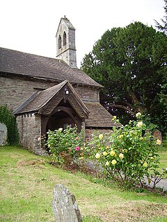
Llansantffraed (Llansantffraed-juxta-Usk) is a parish in the community of Talybont-on-Usk in Powys, Wales near Brecon. The benefice of Llansantffraed with Llanrhystud and Llanddeiniol falls within the diocese of St David's in the Church in Wales.

Brecon, archaically known as Brecknock, is a market town in Powys, mid-Wales. In 1841, it had a population of 5,701. The population in 2001 was 7,901, increasing to 8,250 at the 2011 census. Historically it was the county town of Brecknockshire (Breconshire); although its role as such was eclipsed with the formation of the County of Powys, it remains an important local centre. Brecon is the third-largest town in Powys, after Newtown and Ystradgynlais. It lies north of the Brecon Beacons mountain range, but is just within the Brecon Beacons National Park.
The Brecon Beacons National Park is one of three national parks in Wales, and is centred on the Brecon Beacons range of hills in southern Wales. It includes the Black Mountain in the west, Fforest Fawr and the Brecon Beacons in the centre and the Black Mountains in the east.
Bwlch is a small village and an electoral ward in Powys, southern Wales. The settlement is strung out along the A40 road which crosses a low col above the Usk Valley at this point on its route between Brecon and Crickhowell. The village is a part of the administrative community of Llanfihangel Cwmdu with Bwlch and Cathedine.
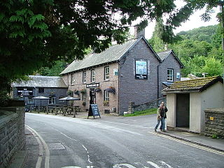
Talybont-on-Usk is a village and community in Powys, Wales, in the historic county of Brecknockshire (Breconshire). It lies on both the River Caerfanell and the Monmouthshire and Brecon Canal, about 1 mile (1.6 km) from the River Usk. In 2001 it had a population of 743, reducing to 719 at the 2011 Census. the community includes the settlements of Llansantffraed, Scethrog, Aber Village, Powys, and Pencelli.

Llangynidr is a village, community and electoral ward in Powys, Wales, about 4 miles (6.4 km) west of Crickhowell and 9 miles (14.5 km) south-east of Brecon. The River Usk flows through the village as does the Monmouthshire and Brecon Canal. It is in the historic county of Brecknockshire.
The Usk Valley Walk is a waymarked long distance footpath in south east Wales, from Caerleon to Brecon.
The Caerfanell is a river which rises in the central section of the Brecon Beacons National Park in Powys, Wales. It rises as Blaen Caerfanell on the plateau of Gwaun Cerrig Llwydion and drops steeply down southeastwards into the head of Glyn Collwn before turning east then north-east into Talybont Reservoir. It emerges from the hydro turbine beneath the dam just above the village of Aber and continues northwards to its confluence with the River Usk at the hamlet of Llansantffraed.

Tor y Foel is a hill in the Brecon Beacons National Park in the county of Powys in Wales. It is located on the eastern flank of Talybont Reservoir, and the summit at 551m is marked by a small cairn. It gives excellent panoramic views over the valley of the River Usk, across to the Black Mountains and west to the Brecon Beacons.

Llangattock is a village, community and electoral ward in the Brecon Beacons National Park in Powys, Wales. It lies in the Usk Valley just across the river from the town of Crickhowell. The Monmouthshire and Brecon Canal passes through the village en route between Brecon and Pontypool. It is in the historic county of Breconshire.

Aber Village or Aber Clydach is a hamlet within the Brecon Beacons National Park in Powys, Wales. It is centred on the minor road which runs south from Talybont-on-Usk up the Caerfanell valley known as Glyn Collwn across the Brecon Beacons to Pontsticill and Merthyr Tydfil. Aber Clydach lies within the community of Talybont-on-Usk about 1.5 km to the south of the village of Talybont and 0.5 km to the north of the dam of Talybont Reservoir.
Llanspyddid is a small village just west of Brecon within the Brecon Beacons National Park. It lies within the valley of the River Usk in the community of Glyn Tarell in the county of Powys, Wales. Llanspyddid sits on the A40 trunk road between Brecon and Llandovery. The Welsh name signifies the 'church of Saint Ysbyddyd', though the village church is in fact dedicated to Saint Cadog.

Llanfrynach is a village and community in the county of Powys, Wales, and the historic county of Brecknockshire. The population of the community as taken at the 2011 census was 571. It lies just to the southeast of Brecon in the Brecon Beacons National Park. The village sits astride the Nant Menasgin, a right bank tributary of the River Usk. The B4558 passes just to its north and the Monmouthshire and Brecon Canal also passes around the village. The Welsh name signifies the 'church of Brynach'. The community includes the hamlets of Llanhamlach and Groesffordd.

Tawe-Uchaf is a community in Powys, Wales. Situated north-east of Ystradgynlais in the upper valley of the River Tawe, it includes the villages of Caehopkin, Coelbren, Glyntawe, Pen-y-cae, Penwyllt and Ynyswen. It had a population in 2001 of 1,516, increasing at the 2011 Census to 1,562.

Glyn Tarell is a valley and a community in the county of Powys, Wales, and the historic county of Brecknockshire. It is in the Brecon Beacons National Park and at the northern edge of the Brecon Beacons mountains.
St Mary is the name of an electoral ward in the town of Brecon, Powys, Wales. It covers the town centre and elects councillors to Brecon Town Council and Powys County Council.

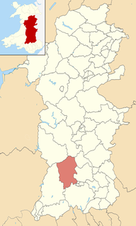
Talybont-on-Usk is the name of an electoral ward in the south of Powys, Wales. It covers three local government communities and elects a councillor to Powys County Council.
Yscir is the name of an electoral ward in southern Powys, Wales. It covers three local government communities and elects a councillor to Powys County Council.
The B4558 road is a road in Powys, central Wales, with a total length of 12 miles (19 km). It begins at a junction with the A4077 road across the Usk bridge from Crickhowell and runs northwest up the southern side of the Usk valley to a junction with the A40 road 3.5km east of Brecon. En route from Crickhowell it passes through the villages of Llangynidr, Talybont-on-Usk, and Pencelli. It is closely followed over this section by the Monmouthshire and Brecon Canal which it crosses six times. River crossings include those of the Nant Cleisfer and Afon Crawnon at Llangynidr, the Caerfanell at Talybont and the Nant Menasgin between Pencelli and Llanfrynach. It crosses the Usk itself by the historic Lock Bridge just south of the village of Groesffordd, east of Brecon.
Groesffordd is a small village within the community of Llanfrynach in the county of Powys, Wales, and the historic county of Brecknockshire. The Welsh name signifies the 'crossroads'. It lies just to the east of Brecon straddling the northern boundary of the Brecon Beacons National Park. The village sits just to the north of the A40 road between Brecon and Crickhowell and north of the River Usk and Monmouthshire and Brecon Canal. The track of the former Brecon and Merthyr Railway runs through the village
References
- ↑ Owen, H.W. & Morgan, R. 2007 'Dictionary of the Place-names of Wales' Gomer Press, Ceredigion
- ↑ Ordnance Survey Explorer map OL12 'Brecon Beacons National Park: western area'
- ↑ "Pencelli Castle".
- ↑ "Community population 2011" . Retrieved 10 November 2015.
- ↑ "The County of Powys (Electoral Arrangements) Order 1998". Legislation.gov.uk. Retrieved 13 October 2018.
