Castine is a town in Hancock County in eastern Maine. The population was 1,366 at the 2010 census. Castine is the home of Maine Maritime Academy, a four-year institution that graduates officers and engineers for the United States Merchant Marine and marine related industries. Approximately 1000 students are enrolled. During the French colonial period, Castine was the southern tip of Acadia and served as the regional capital between 1670 and 1674.

Acadia was a colony of New France in northeastern North America which included parts of eastern Quebec, the Maritime provinces, and Maine to the Kennebec River. During much of the 17th and early 18th centuries, Norridgewock on the Kennebec River and Castine at the end of the Penobscot River were the southernmost settlements of Acadia. The French government specified land bordering the Atlantic coast, roughly between the 40th and 46th parallels. It was eventually divided into British colonies. The population of Acadia included the various indigenous First Nations that comprised the Wabanaki Confederacy, the Acadian people and some small Scottish settlements.

Port-Royal National Historic Site is a National Historic Site located on the north bank of the Annapolis Basin in the community of Port Royal, Nova Scotia. The site is the location of the Habitation at Port-Royal.

Norridgewock was the name of both an Indian village and a band of the Abenaki Native Americans/First Nations, an Eastern Algonquian tribe of the United States and Canada. The French of New France called the village Kennebec. The tribe occupied an area in the interior of Maine. During colonial times, this area was territory disputed between British and French colonists, and was set along the claimed western border of Acadia, the western bank of the Kennebec River.

The Dummer's War was a series of battles between New England and the Wabanaki Confederacy who were allied with New France. The eastern theater of the war was fought primarily along the border between New England and Acadia in Maine, as well as in Nova Scotia; the western theater was fought in northern Massachusetts and Vermont at the border between Canada and New England. During this time, Maine and Vermont were part of Massachusetts.

The Acadians are the descendants of 17th and 18th century French settlers in parts of Acadia in the northeastern region of North America comprising what is now the Canadian Maritime Provinces of New Brunswick, Nova Scotia and Prince Edward Island, the Gaspé peninsula in eastern Québec, and the Kennebec River in southern Maine. Today many share other ethnic ancestries as well, some including from Indigenous peoples.

Charles de Menou d'Aulnay was a pioneer of European settlement in North America and Governor of Acadia (1635–1650).

Charles de Saint-Étienne de La Tour (1593–1666) was a French colonist and fur trader who served as Governor of Acadia from 1631–1642 and again from 1653–1657.
Sir Thomas Temple, 1st Baronet of Nova Scotia was a British proprietor and governor of Acadia/Nova Scotia (1657–70). In 1662, he was created a Baronet of Nova Scotia by Charles II.

The history of New Brunswick covers the period from the arrival of the Paleo-Indians thousands of years ago to the present day. Prior to European colonization, the lands encompassing present-day New Brunswick were inhabited for millennia by the several First Nations groups, most notably the Maliseet, Mi'kmaq, and the Passamaquoddy.

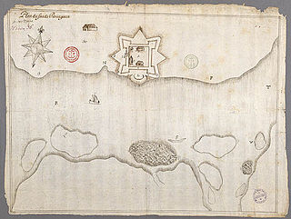
Fort Pentagouët was a French fort established in present-day Castine, Maine, which was the capital of Acadia (1670–1674). It is the oldest permanent settlement in New England.

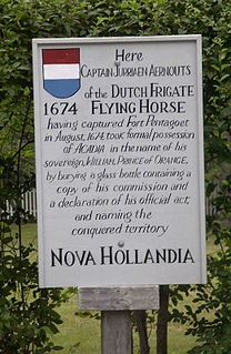
New Holland was a colony established by Dutch naval captain Jurriaen Aernoutsz upon seizing the capital of Acadia, Fort Pentagouet in Penobscot Bay, and several other Acadian villages during the Franco-Dutch War. The Dutch imprisoned the Governor of Acadia Jacques de Chambly. The French and native allies under the command of St. Castin regained control of the area the following year in 1675, however, a year later the Dutch West India Company appointed Cornelis Steenwijck, a Dutch merchant in New York, governor of the "coasts and countries of Nova Scotia and Acadie." The formal Dutch claim to Acadia (1676) was finally abandoned at the end of the war with the Treaty of Nijmegen in 1678.

Port La Tour is a community in the Canadian province of Nova Scotia, located in the Municipality of the District of Barrington of Shelburne County.

Villagedale is a community in the Canadian province of Nova Scotia, located in the Municipality of the District of Barrington of Shelburne County.

Fort William Henry is located in the village of New Harbor in the town of Bristol, Maine. The fort was, in its time, the largest in New England. The fort was originally built in 1692 but destroyed four years later by New France in the Siege of Pemaquid (1696). A reconstruction was built in 1908. The fort was added to the National Register of Historic Places on December 1, 1969. Fort William Henry is now operated as a museum about the fort's history.

Meductic Indian Village / Fort Meductic was a Maliseet settlement until the mid-eighteenth century. It was located near the confluence of the Eel River and Saint John River in New Brunswick, four miles upriver from present-day Meductic, New Brunswick. The fortified village of Meductic was the principal settlement of the Maliseet First Nation from before the 17th century until the middle of the 18th, and it was an important fur trading centre..
The Northeast Coast Campaign (1723) occurred during Father Rale's War from April 19, 1723 – January 28, 1724. In response to the previous year, in which New England attacked the Wabanaki Confederacy at Norridgewock and Penobscot, the Wabanaki Confederacy retaliated by attacking the coast of present-day Maine that was below the Kennebec River, the border of Acadia. They attacked English settlements on the coast of present-day Maine between Berwick and Mount Desert Island. Casco was the principal settlement. The 1723 campaign was so successful along the Maine frontier that Dummer ordered its evacuation to the blockhouses in the spring of 1724.

The Acadian Civil War (1635–1654) was fought between competing governors of the French province of Acadia. Governor Charles de Saint-Étienne de la Tour had been granted one area of territory by King Louis XIV, and Charles de Menou d'Aulnay had been granted another area. The divisions made by the king were geographically uninformed, and the two territories and their administrative centres overlapped. The conflict was intensified by personal animosity between the two governors, and came to an end when d'Aulnay successfully expelled la Tour from his holdings. D'Aulnay's success was effectively overturned after his death when la Tour married D'Aulnay's widow in 1653.

Port-Royal was a settlement on the site of modern-day Annapolis Royal, Nova Scotia, part of the French colony of Acadia. It was founded in 1629 by Sir William Alexander’s Scottish settlers and named Charlesfort. The original French settlement of Port Royal, located approximately 7 kilometres down the Annapolis Basin, had earlier established farms in the area. Upon the handing back of Acadia to the French by the Treaty of Saint-Germain-en-Laye the settlement was occupied by the French and renamed Port Royal. For most of the period until the Siege of Port Royal by the Kingdom of Great Britain in 1710, the village was the capital of Acadia. Port-Royal was the primary Acadian settlement until Acadians migrated out of the community to Pisiguit, Cobequid, Grand Pre, and Beaubassin in the 1680s.

The Maliseet militia were made up of warriors from the Maliseet people of northeastern North America. Along with the Wabanaki Confederacy, the French and Acadian militia, the Maliseet fought the British through six wars over a period of 75 years. They also mobilized against the British in the American Revolution. After confederation, Mi'kmaq warriors eventually joined Canada's war efforts in World War I and World War II.


