
The Hiram M. Chittenden Locks, or Ballard Locks, is a complex of locks at the west end of Salmon Bay in Seattle, Washington's Lake Washington Ship Canal, between the neighborhoods of Ballard to the north and Magnolia to the south.

The Chickamauga Dam is a hydroelectric dam on the Tennessee River in Chattanooga, Tennessee, United States. The dam is owned and operated by the Tennessee Valley Authority, which built the dam in the late 1930s as part of a New Deal era initiative to improve navigation and bring flood control and economic development to the Tennessee Valley. The dam impounds the 36,240-acre (14,670 ha) Chickamauga Lake and feeds into Nickajack Lake. The dam and associated infrastructure were listed on the National Register of Historic Places in 2017.

Kentucky Dam is a hydroelectric dam on the Tennessee River on the county line between Livingston and Marshall counties in the U.S. state of Kentucky. The dam is the lowermost of nine dams on the river owned and operated by the Tennessee Valley Authority, which built the dam in the late 1930s and early 1940s to improve navigation on the lower part of the river and reduce flooding on the lower Ohio and Mississippi rivers. It was a major project initiated during the New Deal of President Franklin D. Roosevelt's administration, to invest in infrastructure to benefit the country. The dam impounds the Kentucky Lake of 160,000 acres (65,000 ha), which is the largest of TVA's reservoirs and the largest artificial lake by area in the Eastern United States. It was designated as an National Historic Civil Engineering Landmark by the American Society of Civil Engineers in 1996 and listed on the National Register of Historic Places in 2017.

General Zebulon Pike Lock and Dam No. 11 is a lock and dam located between Dubuque, Iowa, and rural Grant County, Wisconsin, on the Upper Mississippi River.

Lock and Dam No. 12 is a lock and dam located on the Upper Mississippi River at Bellevue, Iowa, United States. The movable portion of the dam starts at the locks adjacent to the Iowa shore and is 849 feet (258.8 m) long, consisting of seven tainter gates and three roller gates. It connects to a 200-foot (61.0 m) storage yard and continues toward the Illinois shore with a 2,750-foot (838.2 m) non-submersible dike, a 1,200-foot (365.8 m) submersible dike and a 3,130-foot (954.0 m) non-submersible dike. The non-submersible sections are separated from the submersible section with two 120-foot (36.6 m) transitional dikes. The main lock is 110 feet (33.5 m) wide by 600 feet (182.9 m) long. There is also an incomplete auxiliary lock. In 2004, the facility was listed in the National Register of Historic Places as Lock and Dam No. 12 Historic District, #04000172 covering 1,017 acres (4.1 km2), 1 building, 3 structures, and 4 objects.

Lock and Dam No. 13 is a lock and dam located on the Upper Mississippi River above Fulton, Illinois and Clinton, Iowa, United States. This facility offers visitors a view of the barges and boats locking through on the widest pool in the Upper Mississippi River.

Lock and Dam No. 14 is a lock and dam located near LeClaire, Iowa on the Upper Mississippi River above Davenport, Iowa and Moline, Illinois. The movable portion of the dam is 1,343 feet (409.3 m) long and consists of 13 tainter gates and 4 roller gates. Connected to it is a 1,127 feet (343.5 m) long non-submersible rock fill dike which extends to the Illinois side. The main lock is 110 feet (33.5 m) wide by 600 feet (182.9 m) long. The site on the National Register of Historic Places as the Lock and Dam No. 14 Historic District (#04000174) listed in 2004 consisting of 3,043 acres (12.3 km2), 1 building, 6 structures, and 2 objects. It was completed in two phases, the first as part of the six foot channel project from 1921 to 1924, which included a lock and canal bypassing a hazardous rapids. The second phase was part of the nine foot channel project from 1935 to 1939 and included the main dam and the current main lock.

Lock and Dam No. 15 is a lock and dam located on the Upper Mississippi River. It spans the river between Rock Island, Illinois and Davenport, Iowa. Lock and Dam 15 is the largest roller dam in the world, its dam is 1,203 feet (366.7 m) long and consists of nine 109 feet (33.2 m) non-submersible, non-overflow roller gates and two 109 feet (33.2 m) non-submersible overflow roller gates. It is unusual among the upper Mississippi River dams in that it has only roller gates, has different sizes and types of roller gates, it is not perpendicular to the flow of the river and is one of the few facilities that has a completed auxiliary lock. The main lock is 110 feet (33.5 m) wide by 600 feet (180 m) long and its auxiliary lock is 110 feet (34 m) wide by 360 feet (110 m) long. In 2004, the facility was listed in the National Register of Historic Places as Lock and Dam No. 15 Historic District, #04000175 covering 3,590 acres (1,450 ha), 2 buildings, 9 structures, and 1 object.

Lock and Dam No. 20 is a lock and dam located on the Upper Mississippi River, the lock side in Canton, Missouri and the dam crossing to Meyer, Illinois.

Lock and Dam No. 22 is a lock and dam located near Saverton, Missouri, on the Upper Mississippi River around river mile 301.2. The movable portion of the dam is 1,224 feet (373.1 m) long and consists of three roller gates and ten tainter gates. A 1,600 feet (487.7 m) long submersible earthen dike extends to a flood control levee on the Illinois shore. The main lock is 110 feet (33.5 m) wide by 600 feet (182.9 m) long; there is also an incomplete auxiliary lock. In 2004, the facility was listed in the National Register of Historic Places as Lock and Dam No. 22 Historic District, #04000182 covering 1,268 acres (5.1 km2), 1 building, 5 structures, 4 objects.

Lock and Dam No. 24 is a lock and dam located near Clarksville, Missouri around river mile 273.4 on the Upper Mississippi River. The main lock is 110 feet (33.5 m) wide and 600 feet (182.9 m) long with its bottom at an elevation of 430 feet. The auxiliary lock is not operational. Normal pool elevation behind the dam is 449 feet. The movable portion of the dam is 1,340 feet (408.4 m) long and consists of 15 submersible, elliptical, tainter gates. A 2,720 feet (829.1 m) submersible earthen dike extends from the movable dam to the Illinois shore. In 2004, the facility was listed in the National Register of Historic Places as Lock and Dam No. 24 Historic District, #04000183 covering 1,027 acres (4.2 km2), 3 buildings, 15 structures, 4 objects.
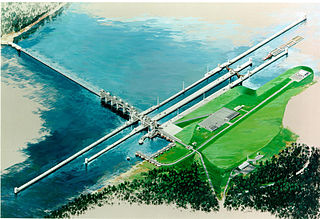
The Olmsted Locks and Dam is a locks and wicket dam on the Ohio River at river mile 964.4. The project is intended to reduce tow and barge delays by replacing the existing older, and frequently congested, locks and dams Number 52 and Number 53. The locks are located about 17 miles upstream from the confluence of the Ohio and Mississippi rivers at Olmsted, Illinois.
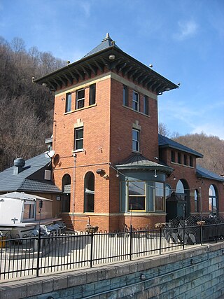
The Merrill Lock No. 6 is the remnant of a historic lock and dam complex located along the Ohio River at Industry, Pennsylvania, United States. The remaining buildings, which now compose a restaurant, are together listed on the National Register of Historic Places.

The Brandon Road Lock and Dam is a lock and dam complex along the Des Plaines River in Joliet, Illinois. The complex was built from 1927 to 1933 in conjunction with the construction of the Illinois Waterway, which allowed for barge travel between Lake Michigan and the Mississippi River. The lock and dam are also used to regulate water levels on the river between Lockport and Joliet. The lock at the complex is 110 by 600 feet and has four Miter gates, with a 34-foot drop. The dam is 2,372 feet (723 m) long and includes concrete and earthen segments. The complex also includes a disused junction lock for the Illinois and Michigan Canal, the control station for the lock, and a modern pump house.

Starved Rock Lock and Dam, also known as Lock and Dam No. 6, is a lock and dam facility managed by the U.S. Army Corps of Engineers along the Illinois River, near Starved Rock. It is part of the Illinois Waterway and was constructed between 1926 and 1933. The lock and dam was added to the National Register of Historic Places as the Starved Rock Lock and Dam Historic District in 2004.

The Kaukauna Locks Historic District is a lock and dam system in Kaukauna, Wisconsin, United States, that carried boat traffic around a rapids of the Fox River starting in the 1850s as part of the Fox–Wisconsin Waterway. It was added to the National Register of Historic Places in 1993 for its significance in engineering and transport.
Walter Mickle Smith, Sr. was a civil engineer who worked primarily on U.S. dams and waterway projects. He was a consulting engineer on the construction of the Panama Canal and Panama Canal Locks and later served as design engineer for the New York Board of Water Supply. He spent much of his career with the State of Illinois waterways division and was its chief engineer until his retirement in 1937. Several of his works built in the 1920s and 1930s as part of the Illinois Waterway project are listed on the National Register of Historic Places, including portions of the Brandon Road Lock and Dam, the Dresden Island Lock and Dam, the Lockport Lock and Power House, and the Marseilles Lock and Dam.

The Dresden Island Lock and Dam is a 23.4-acre (9.5 ha) Lock and Dam complex on the Illinois River in Morris, Illinois. The dam was completed in 1933 and designed by engineer Walter Mickle Smith. It was listed on the National Register of Historic Places in 2004. The listing included one contributing building and three contributing structures.

The Marseilles Lock and Dam, also known as Lock and Dam 5, is a lock and dam complex on the Illinois River at Marseilles, Illinois. The complex includes a lock, dam, control station, boiler house, and a 2.5 miles (4.0 km) section of navigation canal. The state of Illinois began work on the complex in 1920 by digging the canal, which was completed in 1925. The state also began construction on the lock, dam, and control station; however, due to financial difficulties these projects were finished by the U.S. Army Corps of Engineers. Walter Mickle Smith was chief design engineer for the complex. The complex was completed in 1933. The lock has a drop of 24 feet.

LaGrange Lock and Dam is a lock and dam complex on the Illinois River at Versailles, Illinois. The structure includes a 1,066 feet (325 m) dam and a 110 by 600 feet lock. The U.S. Army Corps of Engineers built the complex from 1936 to 1939; A.F. Griffin designed the lock and dam, while Paul Le Gromwell designed the control station. The lock and dam, as well as a similar lock and dam near Peoria, were needed when the authorized channel depth was raised to nine foot. The Peoria and LaGrange locks replaced older locks on the lower Illinois River. The lock uses Chanoine wicket gates, which allow for navigation on the river, rather than the Tainter gates seen elsewhere on the river.


