Cilandak is a district in the administrative city of South Jakarta, Indonesia. The Krukut River flows through the eastern edge of Cilandak, while the Pesanggrahan and Grogol Rivers flow through the western edge.

Tangerang is the city with the largest population in the province of Banten, Indonesia. Located on the western border of Jakarta, it is the sixth largest city proper in the nation. It has an area of 164.55 km2 (63.53 sq mi) and an official 2010 Census population of 1,798,601, which had risen to 1,895,486 at the 2020 Census – making it the eighth most populated suburb in the world at the latter date; the official estimate as at mid 2023 was 1,912,679 - comprising 961,354 males and 951,325 females.

Tangerang Regency is a regency of Banten Province, Indonesia. It is located in the northwest of the island of Java. The current regent is Ahmed Zaki Iskandar. Though commonly misunderstood as being a part of Jakarta, Tangerang is actually outside Jakarta City but is part of Greater Jakarta. Since 1993, the regency has lost territory as first Tangerang city was split off on 27 February 1993 and subsequently South Tangerang city was split off on 29 October 2008. The residual Regency now has an area of 1,034.54 km2 and a population of 2,834,376 at the 2010 census, growing to 3,245,619 at the 2020 census; the latest official estimate is 3,309,365, reflecting a recent slowing down in the rate of population growth since 2020. The town of Tigaraksa is the regency seat.

Kembangan is a district in West Jakarta, Indonesia. Kembangan is bounded by Pesanggrahan Subdistrict to the south, Tangerang Regency to the south and west, Cengkareng Subdistrict to the north, and Kebon Jeruk Subdistrict to the east. The City Hall of West Jakarta is located in this district.

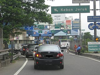
Kebon Jeruk is a district (kecamatan) of West Jakarta Administrative City, Indonesia. Kebon Jeruk is roughly bounded by Kali Pesanggrahan creek to the west, Kebayoran Lama Road to the south, Daan Mogot Road to the north, and Rawa Belong - Batu Sari Road to the east. The area is approximately 17.54 square km, and the official estimate of population as at mid 2023 was 370,282.

The Jakarta–Serpong Toll Road, also known as Ulujami–Serpong Toll Road, is a toll road connecting South Jakarta and South Tangerang in the province of Banten, Indonesia. Operated by Jasa Marga and Nusantara Infrastructure, this toll road is connected to the Jakarta Outer Ring Road in Ulujami and Petukangan areas.

Ciputat is a town and an administrative district (kecamatan) in the city of South Tangerang, in Banten Province on Java, Indonesia and is inside the Greater Jakarta metropolitan area. It covers an area of 21.11 km2 and had a population of 192,205 at the 2010 Census and 202,722 at the 2020 Census; the official estimate as at mid 2023 was 222,186.

Pondok Aren is a town and an administrative district (kelurahan) in the city of South Tangerang, in Banten Province on Java, Indonesia. It is located on the south-western outskirts of Jakarta. The district covers 29.80 km2 and had a population of 303,093 at the 2010 Census and 294,996 at the 2020 Census; the official estimate as at mid 2023 was 295,812.

South Tangerang is a city in the province of Banten, Indonesia. Located 30 km (19 mi) on the southwestern border of Jakarta, the city forms part of the Greater Jakarta metropolitan area. It was administratively separated from Tangerang Regency on 26 November 2008. According to the 2020 Census, the city population was 1,354,350 inhabitants, while the official estimate as at mid 2023 was 1,404,785 - comprising 700,754 males and 704,031 females. The total area is 164.85 km2 (63.65 sq mi). It is the second-largest city in Banten in terms of population, and has grown rapidly, not only as Jakarta's satellite city, but also the development of business districts and commerce due to presence of large-scale planned town by private developers.

Koperasi Angkutan Jakarta or Kopaja was a cooperative established in 1971 to provide public transport services in Jakarta. There were reportedly over 1,400 minibuses in the Kopaja fleet in mid-2012, more than half of which were estimated to be over 20 years old.

BSD City, formerly referred to Bumi Serpong Damai is a planned community located within Greater Jakarta in Indonesia. The project was initiated in 1984 by a group of private developers and started in 1989. The town is currently managed by the holding company PT Bumi Serpong Damai Tbk, which is owned by Sinar Mas Land, a subsidiary of the Sinar Mas Group, a large industrial conglomerate in Indonesia. BSD City encompasses a total area of approximately 6,000 hectares, hosting a range of residential houses, apartments, malls, offices, and more. Most of the residential areas are designed to be suitable for Indonesia's upper-middle class, in gated neighbourhoods, each with different themes. The city is now a self-sustaining community, with businesses, schools, shopping malls, hospitals and hotels.

Jalan M.H. Thamrin or Jalan Thamrin is a major thoroughfare in Jakarta, Indonesia. The road is located at the center of Jakarta, running from the north end of Jalan Jenderal Sudirman at West Flood Canal at the south end to the roundabout near Arjuna Wijaya Statue Jakarta at the north end. Developed in the 1950s, the road was a landmark of post-colonial Indonesia and continues to have a prominent importance in Jakarta.

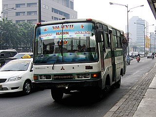
The MetroMini minibus system was a major part of the public transport system of Jakarta. There were reportedly over 3,000 buses in the MetroMini fleet in mid-2012. The buses are similar to the parallel Kopaja system which also provides transport services, on different routes, across Jakarta. The distinctive MetroMini buses are orange and blue with a white stripe running along the length of the bus. Buses provide seating for around 20-30 people with, often, an equal number crammed into limited standing room so the buses are often overcrowded. But at 2015 Jakarta Governor Basuki Tjahaja Purnama stopped all of MetroMini's bus operations because of a MetroMini vs KRL Commuter Line crash. If MetroMini wants to operate again, it has to join Transjakarta like the Kopaja as a feeder bus. Many routes are/will replaced/replaced by Minitrans and Metrotrans buses.

Jurangmangu Station (JMG) is a class III railway station located in Sawah Lama, Ciputat, South Tangerang. The station is located at an elevation of +25 meters above sea level and is included in Operation Area I Jakarta. Even though it is called Jurangmangu, this station is not located in Jurangmangu Village, Pondok Aren District, but is located in the south of Jurangmangu village itself.

Gading Serpong is a planned township, 21 km west of Jakarta at Kelapa Dua and Pagedangan, Tangerang Regency of Banten province in Indonesia.

Bintaro Jaya is a planned township located in Greater Jakarta, Indonesia. It is developed by PT Jaya Real Property Tbk. The development of the township began within South Jakarta in 1979 and is expanded further to South Tangerang in Banten province. The township is built as a satellite city for Jakarta, with a total land area of about 1000 hectares. The name Bintaro is derived from the Bintaro Village, which also takes the name of Bintaro plant, whereas Jaya came from the name of the developer. Bintaro Jaya along with Bumi Serpong Damai (BSD) is one of the largest township in Indonesia.

Transjakarta Corridor 13 is a bus rapid transit corridor in Greater Jakarta, Indonesia, operated by Transjakarta. It serves the route from CBD Ciledug BRT station in Tangerang, Banten, to Tegal Mampang BRT station in Mampang Prapatan, South Jakarta; though it is currently shortened temporarily and starts from Puri Beta 2 station. The roads traversed by Corridor 13 are HOS Tjokroaminoto (Tangerang), Ciledug Raya, Kebayoran Lama, Kyai Maja, Trunojoyo, Wolter Monginsidi, and Kapten Tendean. This is the first corridor on the BRT system to operate on a separated elevated track, running via a 9.3 kilometre long and 8 metre wide dedicated elevated bus lane, with height ranging from 18 to 23 metres above ground level. The elevated track starts from Kapten Tendean Road where Tegal Mampang station is located and spans all the way to Ciledug Raya Road near intersection with Adam Malik Road, where Petukangan Utara station is located.
East Ciputat is an administrative district (kecamatan) in the city of South Tangerang, Banten Province, on Java, Indonesia. It is inside the Greater Jakarta metropolitan area, and is situated to the east of Ciputat. It covers an area of 17.81 km2 and its population was 178,818 at the 2010 Census and 172,139 at the 2020 Census; the official estimate as at mid 2023 was 169,555.


