
The Picos de Europa are a mountain range extending for about 20 km, forming part of the Cantabrian Mountains in northern Spain. The range is situated in the Autonomous Communities of Asturias, Cantabria and Castile and León. The highest peak is Torre de Cerredo, at an elevation of 2650 m.

Pico de Orizaba, also known as Citlaltépetl, is a stratovolcano, the highest mountain in Mexico and the third highest in North America, after Denali of Alaska in the United States and Mount Logan of Canada. It rises 5,636 metres (18,491 ft) above sea level in the eastern end of the Trans-Mexican Volcanic Belt, on the border between the states of Veracruz and Puebla. The volcano is currently dormant but not extinct, with the last eruption taking place during the 19th century. It is the second most prominent volcanic peak in the world after Africa's Mount Kilimanjaro.

Manhuaçu is a municipality in Eastern Minas Gerais state, in Brazil. Its population was 86,844 (2015) and its area is 628 km².

Pico das Agulhas Negras is the fifth-highest mountain in Brazil, standing at 2,791 metres (9,157 ft) above sea level, making it one of the highest in the Brazilian Highlands. It is located in Itatiaia National Park, in the Serra da Mantiqueira range, on the border of the states of Rio de Janeiro and Minas Gerais. It is the highest point in the state of Rio de Janeiro, the third-highest peak in Minas Gerais, and the second-highest in the Mantiqueira range.

The Cerro de la Silla is a mountain and natural monument located within the metropolitan area of the city of Monterrey, Nuevo León, in northeastern Mexico. Named for its distinctive saddle-shaped profile when viewed from the west, it is a well-known symbol of the city of Monterrey, despite being located in the adjacent municipality of Guadalupe.

Pico da Neblina is the highest peak in Brazil, 2,995.3 metres (9,827 ft) above sea level, in the Serra da Neblina, part of the Serra do Imeri, a section of the Guiana Highlands on the Brazil–Venezuela border. As determined by a border survey expedition in 1962, its summit lies just within Brazilian territory, at a horizontal distance of only 687 m (2,254 ft) from the Venezuelan border at Pico 31 de Março.

The Cantabrian Mountains or Cantabrian Range are one of the main systems of mountain ranges in Spain. They stretch for over 300 km (180 miles) across northern Spain, from the western limit of the Pyrenees to the Galician Massif in Galicia, along the coast of the Cantabrian Sea. Their easternmost end meets the Sistema Ibérico.

Killington Mountain Resort & Ski Area is a ski resort in the northeast United States, near Killington, Vermont. It is the largest ski area in the eastern U.S., and has the largest vertical drop in New England at 3,050 feet. Starting in the 2013–14 ski season, it was given the title "Beast of the East."

Pico Bolívar is the highest mountain in Venezuela, at 4,978 metres. Located in Mérida State, its top is permanently covered with névé snow and three small glaciers. It can be reached only by walking; the Mérida cable car, was the highest and longest cable car in the world when it was built, and only reaches Pico Espejo. From there it is possible to climb to Pico Bolívar. The peak is named after the Venezuelan independence hero Simón Bolívar.

Mount Pico is a stratovolcano located on Pico Island, in the mid-Atlantic archipelago of the Azores. It is the highest mountain of Portugal, at 2,351 metres (7,713 ft) above sea level, and is one of the highest Atlantic mountains; it is more than twice the elevation of any other peak in the Azores.

Pico Peak is a mountain located in Rutland County, Vermont, United States. It is the northernmost summit of the Coolidge Range in the Green Mountains, and the second highest in the Coolidge Range after Killington Peak. Pico Peak is flanked to the south by Ramshead Peak, and to the north faces Deer Leap Mountain across Sherburne Pass. The peak's name may stem from the Abenaki for "the pass/opening" or indeed from the Spanish or Portuguese word for "peak", Pico. Seen from Sherburne Pass the summit resembles a cone. "Pico Peak" appears on the 1869 Beers Atlas of Rutland County, Walling's 1860 Map of the State of Vermont and Chace's 1854 Map of Rutland County.

Pico do Jaraguá is the highest mountain in the Brazilian city of São Paulo, at 1135 metres above sea level, located at the Serra da Cantareira. Jaraguá means Lord of the Valley in Tupi.

Pico Mountain Ski Area is a ski area located in Killington, Vermont, United States. Established in 1937, it was one of the first commercial ski resorts in the state. The base of the resort is located on the northwest side of Pico Peak on U.S. Route 4 approximately 9 miles northeast of Rutland, Vermont, and 3 mi (5 km) north of Killington Peak. The site lies just inside the town line that separates Killington from the Town of Mendon, to its west. The mountain now features 57 trails and 7 lifts with a 1,967-foot (600-meter) vertical drop.

Pico Bonito National Park is a national park in Honduras. It was established on January 1,1987 and covers an area of 564.30 km2 (217.88 sq mi). It has an altitude ranging between 60 and 2,480 metres.
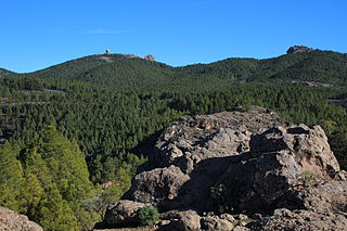
Pico de las Nieves is the highest peak of Gran Canaria Canary Islands, Spain. Its height is 1,949 metres (6,394 ft) above sea level. The origin is volcanic (stratovolcano). On its slopes, Canary Islands Pine was reintroduced in the 1950s.

Picos de Urbión, or "Urbion Peaks" is a mountain range in the Sistema Ibérico, Spain, limited by the Sierra de Neila and Sierra Cebollera of the same range. The ridge's highest summit, Pico Urbión, is 2,228 m) is one of the highest points in the 500 km long Sistema Ibérico.

Sierra de Algairén is a mountain range in Aragon, Spain, located between the comarcas of Campo de Cariñena and Comunidad de Calatayud. The ridge's highest summit is Pico de Valdemadera (1,276 m).
Los Angeles Assembly was a former Ford Motor Company assembly plant located at 8820 Washington Boulevard and Rosemead Boulevard, in Pico Rivera, southwestern Los Angeles County, California.


