
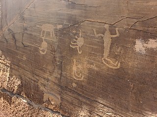
Newspaper Rock State Historic Monument is a Utah state monument featuring a rock panel carved with one of the largest known collections of petroglyphs. It is located in San Juan County, along Utah State Route 211, 28 miles (45 km) northwest of Monticello and 53 miles (85 km) south of Moab.

Starved Rock State Park is a state park in the U.S. state of Illinois, characterized by the many canyons within its 2,630 acres (1,064 ha). Located just southeast of the village of Utica, in Deer Park Township, LaSalle County, Illinois, along the south bank of the Illinois River, the park hosts over two million visitors annually, the most for any Illinois state park.

El Morro National Monument is a U.S. national monument in Cibola County, New Mexico, United States. Located on an ancient east–west trail in the western part of the state, the monument preserves the remains of a large prehistoric pueblo atop a great sandstone promontory with a pool of water at its base, which subsequently became a landmark where over the centuries explorers and travelers have left personal inscriptions that survive today.

Washington State Park is a public recreation area covering 2,147 acres (869 ha) in Washington County in the central eastern part of the state of Missouri. It is located on Highway 21 about 14 miles (23 km) northeast of Potosi or 7 miles (11 km) southwest of DeSoto on the eastern edge of the Ozarks. The state park is noted for its Native American rock carvings and for its finely crafted stonework from the 1930s.

Millstone Bluff is a natural bluff in Pope County, Illinois, United States, located near the community of Glendale. Listed on the National Register of Historic Places because of its archaeological significance, Millstone Bluff is one of three National Register sites in Pope County, along with the Golconda Historic District and part of the Kincaid Mounds State Historic Site.
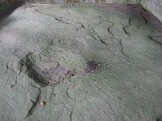
The Leo Petroglyph is a sandstone petroglyph containing 37 images of humans and other animals as well as footprints of each. The petroglyph is located near the small village of Leo, Ohio and is thought to have been created by the Fort Ancient peoples. The area in which the sandstone petroglyph was found is on the edge of an unglaciated Mississippian sandstone cliff 20–65 feet (6.1–19.8 m) high. A 20 by 16 feet slab containing the 37 carvings is protected by a wooden shelter, a Works Progress Administration project. The meanings of the drawings are unknown. On November 10, 1970, it was added to the National Register of Historic Places. The site is maintained by the Ohio History Connection.

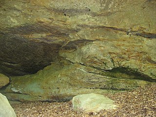
The Modoc Rock Shelter is a rock shelter or overhang located beneath the sandstone bluffs that form the eastern border of the Mississippi River floodplain at which Native American peoples lived for thousands of years. This site is significant for its archaeological evidence of thousands of years of human habitation during the Archaic period in the Eastern United States. It is located on the northeastern side of County Road 7 southeast of Prairie du Rocher in Randolph County, Illinois, United States. It was declared a National Historic Landmark in 1961.

Coso Rock Art District is a rock art site containing over 100,000 Petroglyphs by Paleo-Indians and/or Native Americans. The district is located near the towns of China Lake and Ridgecrest, California. Big and Little Petroglyph Canyons were declared a National Historic Landmark in 1964. In 2001, they were incorporated into this larger National Historic Landmark District. There are several other distinct canyons in the Coso Rock Art District besides the Big and Little Petroglyph Canyons. Also known as Little Petroglyph Canyon and Sand Tanks, Renegade Canyon is but one of several major canyons in the Coso Range, each hosting thousands of petroglyphs. The majority of the Coso Range images fall into one of six categories: bighorn sheep, entopic images, anthropomorphic or human-like figures, other animals, weapons & tools, and "medicine bag" images. Scholars have proposed a few potential interpretations of this rock art. The most prevalent of these interpretations is that they could have been used for rituals associated with hunting.

The V Bar V Heritage Site is the largest known petroglyph site in the Verde Valley of central Arizona, and one of the best-preserved. The rock art site consists of 1,032 petroglyphs in 13 panels. Acquired by the Coconino National Forest in 1994, the site is protected and kept open to the public by the US Forest Service. Volunteers from the Verde Valley Archaeological Society and the Friends of the Forest provide interpretive tours and on-site management.

This is a list of the National Register of Historic Places listings in Randolph County, Illinois.

The Barnesville Petroglyph petroglyph site in the eastern part of the U.S. state of Ohio. Located approximately 3 miles (4.8 km) southwest of the village of Barnesville in Belmont County, the petroglyphs have been known both by archaeologists and the general public since the 1850s or earlier. Although the site was significantly damaged during the twentieth century, it is still a significant archaeological site, and has been named a historic site.
The Arch Creek Petroglyphs, also known as Site 48CK41 are Native American rock art figures located in Crook County, Wyoming. The site, in the southern Black Hills, is unusual in featuring comparatively long, narrow line figures incised on the rock, compared to more common V-necked anthropomorphs and shield figures. The site is particularly well preserved and is protected.

The Sugar Grove Petroglyphs are a group of petroglyphs in the southwestern part of the U.S. state of Pennsylvania. Located on an outcrop of sandstone in Monongahela Township near the eastern edge of Greene County, the petroglyphs have been known since at least the 1930s. Due to their value as an archaeological site, the petroglyphs have been named a historic site.
Petroglyph Canyon (24CB601) is an archaeologically significant canyon in the northwestern United States. Located on both sides of the border between Montana and Wyoming, the canyon has long been obscure due to its small size. However, it gained substantial attention in the late 20th century because of its numerous prehistoric petroglyphs, and much of it was named a historic site in the 1970s.

The Picture Rock Pass Petroglyphs Site is in northern Lake County, Oregon, United States. The site is located near the summit of Picture Rock Pass on land administered by the Bureau of Land Management. The designs were scraped into a basalt boulder by ancient Native Americans, probably between 7,500 and 12,000 years ago. No one knows the meaning of the petroglyph designs. Because of its unique archaeological and cultural significance, the Picture Rock Pass Petroglyph Site was listed on the National Register of Historic Places in 1975.

The Piney Creek South Site is a prehistoric rock art site located on the south side of Piney Creek in Piney Creek Ravine State Natural Area in Randolph County, Illinois. The site consists of two groups of petroglyphs drawn on a sandstone rockshelter. The petroglyphs most likely date from the Late Woodland period, which lasted from 450 to 900 A.D. The larger petroglyph group contains ten designs: four anthropomorphs, a quadruped resembling a deer, three crosses, and two pits. The four designs in the smaller group include two anthropomorphs, a group of pits extending from an anthropomorph's head, and a pecked area. Several of the anthropomorphs appear to have wings, two are carrying shields or rattles, one appears to have a beak, and one may have a crude penis. The site likely had spiritual significance, and the anthropomorphs may represent shamans, who were frequently depicted with wings in Native American art.
The Piney Creek West Site is a prehistoric rock art site located north of Piney Creek in Piney Creek Ravine State Natural Area in Randolph County, Illinois. The site consists of four petroglyphs painted on the inside of a rock shelter and a pictograph painted on the outside. The interior petroglyphs include an abstract shape, two curved lines, and a serpentine line with a pit at one end; two of the petroglyphs are filled in with ochre pigment, representing the only intact example of this painting technique in Illinois. The pictograph, which has deteriorated badly, depicts a human left hand; nearby flecks of paint from an unrecognizably faded figure likely indicate the site of the right hand. The paintings were likely added during the Late Woodland period, which lasted from 450 to 900 A.D. The serpentine figure inside the shelter suggests that the site had spiritual significance, as it resembles other prehistoric rock art depicting shamanic trance states.

The Tegtmeyer Site is a prehistoric rock art site located north of Piney Creek in Piney Creek Ravine State Natural Area in Randolph County, Illinois. The site consists of two petroglyphs painted on a sandstone rock shelter. One petroglyph depicts a winged anthropomorph in flight, while the other depicts a winged zoomorph which may also be flying. Based on their similarity to other sites from the period, the petroglyphs at the site most likely date from the Mississippian period. The petroglyphs resemble some of the figures painted at the nearby Piney Creek Site; given that the Tegtmeyer Site was unsuitable for inhabitation, it was most likely used for additional paintings which could not fit at the Piney Creek Site.
Aiken's Wash is an archaeologically and geologically significant wash located in the Mojave National Preserve in San Bernardino County, California. The wash includes several pictograph and petroglyph sites dating from the late pre-Columbian period. The proximity of pictographs and petroglyphs is unusual in the Mojave Desert region. The area was added to the National Register of Historic Places as the Aiken's Wash National Register District. The district comprises 1,450 acres (590 ha), including all major archaeological sites in the wash.
The Marshall Site is an archaeological site in the Marshall State Fish and Wildlife Area in Marshall County, Illinois, across the Illinois River from Chillicothe. The site consists of a boulder carved with five petroglyphs. The petroglyphs, which archaeologists believe were created by Native Americans between 1673 and 1835, depict three anthropomorphs, an "L"-shaped figure, and a possible avimorph. The site was added to the National Register of Historic Places on August 25, 2014.


