Related Research Articles
Soil structure describes the arrangement or the way of soil in the solid parts of the soil and of the pore space located between them. It is determined by how individual soil granules clump, bind together, and aggregate, resulting in the arrangement of soil pores between them. Soil has a major influence on water and air movement, biological activity, root growth and seedling emergence. There are several different types of soil structure. It is inherently a dynamic and complex system that is affected by different factors.
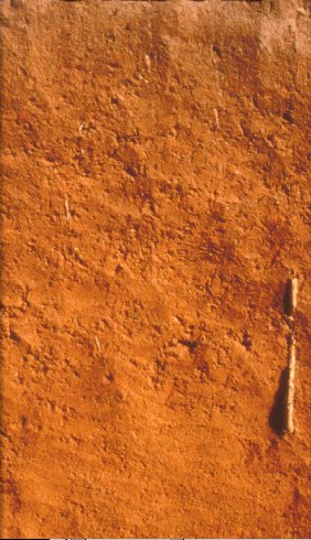
Oxisols are a soil order in USDA soil taxonomy, best known for their occurrence in tropical rain forest within 25 degrees north and south of the Equator. In the World Reference Base for Soil Resources (WRB), they belong mainly to the ferralsols, but some are plinthosols or nitisols. Some oxisols have been previously classified as laterite soils.
USDA soil taxonomy (ST) developed by the United States Department of Agriculture and the National Cooperative Soil Survey provides an elaborate classification of soil types according to several parameters and in several levels: Order, Suborder, Great Group, Subgroup, Family, and Series. The classification was originally developed by Guy Donald Smith, former director of the U.S. Department of Agriculture's soil survey investigations.

Schirmer's test determines whether the eye produces enough tears to keep it moist. This test is used when a person experiences very dry eyes or excessive watering of the eyes. It poses no risk to the subject. A negative test result is normal. Both eyes normally secrete the same amount of tears.
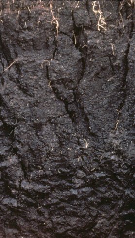
A vertisol, or vertosol, is a soil type in which there is a high content of expansive clay minerals, many of them known as montmorillonite, that form deep cracks in drier seasons or years. In a phenomenon known as argillipedoturbation, alternate shrinking and swelling causes self-ploughing, where the soil material consistently mixes itself, causing some vertisols to have an extremely deep A horizon and no B horizon.. This heaving of the underlying material to the surface often creates a microrelief known as gilgai.
A soil horizon is a layer parallel to the soil surface whose physical, chemical and biological characteristics differ from the layers above and beneath. Horizons are defined in many cases by obvious physical features, mainly colour and texture. These may be described both in absolute terms and in terms relative to the surrounding material, i.e. 'coarser' or 'sandier' than the horizons above and below.

Entisols are soils defined in USDA soil taxonomy that do not show any profile development other than an A horizon. An entisol has no diagnostic horizons, and most are basically unaltered from their parent material, which can be unconsolidated sediment or rock. Entisols are the most abundant soil order, occupying about 16% of the global ice-free land area.

Water content or moisture content is the quantity of water contained in a material, such as soil, rock, ceramics, crops, or wood. Water content is used in a wide range of scientific and technical areas, and is expressed as a ratio, which can range from 0 to the value of the materials' porosity at saturation. It can be given on a volumetric or mass (gravimetric) basis.

Dry rot is wood decay caused by one of several species of fungi that digest parts of the wood which give the wood strength and stiffness. It was previously used to describe any decay of cured wood in ships and buildings by a fungus which resulted in a darkly colored deteriorated and cracked condition.
Claypan is a dense, compact, slowly permeable layer in the subsoil. It has a much higher clay content than the overlying material, from which it is separated by a sharply defined boundary. The dense structure restricts root growth and water infiltration. Therefore, a perched water table might form on top of the claypan. In the Canadian classification system, claypan is defined as a clay-enriched illuvial B (Bt) horizon.

A gleysol is a wetland soil that, unless drained, is saturated with groundwater for long enough to develop a characteristic gleyic colour pattern. The pattern is essentially made up of reddish, brownish, or yellowish colours at surfaces of soil particles and/or in the upper soil horizons mixed with greyish/blueish colours inside the peds and/or deeper in the soil. Gleysols are also known as Gleyzems, meadow soils, Aqu-suborders of Entisols, Inceptisols and Mollisols, or as groundwater soils and hydro-morphic soils.
Soil color does not affect the behavior and use of soil; however, it can indicate the composition of the soil and give clues to the conditions that the soil is subjected to. Soil can exhibit a wide range of colour; grey, black, white, reds, browns, yellows and greens. Varying horizontal bands of colour in the soil often identify a specific soil horizon. The development and distribution of color in soil results from chemical and biological weathering, especially redox reactions. As the primary minerals in soil parent material weather, the elements combine into new and colorful compounds. Soil conditions produce uniform or gradual color changes, while reducing environments result in disrupted color flow with complex, mottled patterns and points of color concentration.
The Canadian System of Soil Classification is more closely related to the American system than any other, but they differ in several ways. The Canadian system is designed to cover only Canadian soils. The Canadian system dispenses with the sub-order hierarchical level. Solonetzic and Gleysolic soils are differentiated at the order level.
A duripan is a diagnostic soil horizon of the USDA soil taxonomy that is cemented by illuvial silica into a subsurface hardpan. Similar to a fragipan, Petrocalcic Horizon and petrogypsic horizon, it is firmly cemented and restricts soil management. In soil descriptions, they are most often denoted by the symbol Bqm. The closest equivalent in the Canadian system of soil classification is called a duric horizon, although it does not mean exactly the same thing as a duripan in the United States. They form almost exclusively in arid or Mediterranean climates, and can be as hard as concrete, which makes plowing very difficult or impossible. Soils that include duripans are generally used for grazing or wildlife habitat, and are seldom cultivated.
A fragipan is a diagnostic horizon in USDA soil taxonomy. They are altered subsurface soil layers that restrict water flow and root penetration. Fragipans are similar to a duripan in how they affect land-use limitations. In soil descriptions, they are commonly denoted by a Bx or Btx symbol. They often form in loess ground. The first record of fragipans is probably that by John Hardcastle in New Zealand in the 1880s.
A gilgai is a small, ephemeral lake formed from a depression in the soil surface in expanding clay soils. Additionally, the term "gilgai" is used to refer to the overall micro-relief in such areas, consisting of mounds and depressions, not just the lakes themselves. The name comes from an Australian Aboriginal word meaning small water hole. These pools are commonly a few metres across and less than 30 cm (12 in) deep, however in some instances they may be several metres deep and up to 100 m (330 ft) across. Gilgais are found worldwide wherever cracking clay soils and pronounced wet and dry seasons are present. Gilgais are also called "melonholes, crabholes, hogwallows or puff and shelf formations".

Laterite is both a soil and a rock type rich in iron and aluminium and is commonly considered to have formed in hot and wet tropical areas. Nearly all laterites are of rusty-red coloration, because of high iron oxide content. They develop by intensive and prolonged weathering of the underlying parent rock, usually when there are conditions of high temperatures and heavy rainfall with alternate wet and dry periods. Tropical weathering (laterization) is a prolonged process of chemical weathering which produces a wide variety in the thickness, grade, chemistry and ore mineralogy of the resulting soils. The majority of the land area containing laterites is between the tropics of Cancer and Capricorn.

Peds are aggregates of soil particles formed as a result of pedogenic processes; this natural organization of particles forms discrete units separated by pores or voids. The term is generally used for macroscopic structural units when observing soils in the field. Soil peds should be described when the soil is dry or slightly moist, as they can be difficult to distinguish when wet.
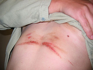
Chafing is an irritation of skin caused by friction, moisture or irritating fabric. Prolonged rubbing on the skin may result in skin sting or burn, and development of a mild, red rash; and in severe cases may include swelling, bleeding, or crusting. It often results from body parts that rub against each other or against clothing. It commonly occurs on the inner thighs and buttocks, and nipples, groin, feet, and armpits can also chafe, although there it is less common. Severe chafing is known as friction burn.

Soil aggregate stability is a measure of the ability of soil aggregates—soil particles that bind together—to resist breaking apart when exposed to external forces such as water erosion and wind erosion, shrinking and swelling processes, and tillage. Soil aggregate stability is a measure of soil structure and can be affected by soil management.
References
- 1 2 Soil Survey Staff (2006). "Keys to Soil Taxonomy, 10th edition" (PDF). United States Department of Agriculture - Natural Resources Conservation Service. Archived from the original (PDF) on 2006-09-22. Retrieved 2006-06-21.
- ↑ Soil Survey Staff (1993). "Examination and Description of Soils". Soil Survey Manual. United States Department of Agriculture - Natural Resources Conservation Service. Archived from the original on 2006-02-06. Retrieved 2006-06-21.