
North Potomac is a census-designated place and an unincorporated area in Montgomery County, Maryland, United States.

Travilah is a U.S. census-designated place and an unincorporated area in Montgomery County, Maryland and near the wealthy U.S. suburban community of Potomac. Residents generally identify as living in Potomac, Rockville, Darnestown, or North Potomac, depending on the area they live in and the zip code they are under. Travilah does not have a zip code.
The Little Monocacy River is a 10.1-mile-long (16.3 km) tributary stream of the Potomac River. Despite its name, the stream does not feed into the Monocacy River. The Little Monocacy is located almost entirely in Montgomery County, Maryland, and enters the Potomac just downstream from where the Monocacy enters the Potomac. Its headwaters rise southwest of Comus, and most of its approximately 17-square-mile (44 km2) watershed is farmland and pasture (60.56%) or forested land (36.03%).
Back Creek is a 59.5-mile-long (95.8 km) tributary of the Potomac River that flows north from Frederick County, Virginia, to Berkeley County in West Virginia's Eastern Panhandle. Back Creek originates along Frederick County's border with Hampshire County, West Virginia, at Farmer's Gap in the Great North Mountain. Its name reflects its location to the west of North Mountain. The perspective of colonists from the east in the 18th century led them to call it "Back Creek", because it lay to the back of North Mountain.

Seneca Creek is a 5.8-mile-long (9.3 km) stream in Montgomery County, Maryland, USA, roughly 16 miles (26 km) northwest of Washington, D.C. It drains into the Potomac River.

Catoctin Creek is a 27.9-mile-long (44.9 km) tributary of the Potomac River in Frederick County, Maryland, USA. Its source is formed in the Myersville, Maryland area and flows directly south for the entire length of the stream. Catoctin Creek enters the Potomac River east of Brunswick. The stream flows through Catoctin Creek Park.
Green Spring Run is an 8.9-mile-long (14.3 km) tributary stream of the North Branch Potomac River in Hampshire County in the U.S. state of West Virginia. Green Spring Run rises in Greenwood Hollow north of Springfield and meanders northeast through Green Spring Valley. The South Branch Valley Railroad and Green Spring Road run parallel to the stream. It runs through the community of Green Spring, from which the stream takes its name. From Green Spring, Green Spring Run flows east where it reaches its confluence with the North Branch Potomac shortly before the North Branch joins with the South Branch Potomac River to form the Potomac River.
Fifteenmile Creek is a 19.9-mile-long (32.0 km) tributary stream of the Potomac River in the U.S. states of Maryland and Pennsylvania. The creek enters the Potomac River through Maryland's Green Ridge State Forest.
Little Conococheague Creek is a 12.4-mile-long (20.0 km) tributary stream of the Potomac River in the U.S. states of Maryland and Pennsylvania. The stream rises on Two Top Mountain, west of the Whitetail Ski Resort in Franklin County, Pennsylvania, and proceeds south into Washington County, Maryland. It empties into the Potomac about 2 miles (3 km) southeast of Big Spring, Maryland. The watershed of the creek is 18 square miles (47 km2) and includes Indian Springs Wildlife Management Area. Tributaries include Toms Run.
Weverton is an unincorporated community hamlet located in the southern tip of Washington County, Maryland, near the north shore of the Potomac River. Its population is approximately 500. Weverton is located at the intersection of MD Route 67 and U.S. Route 340. The nearest incorporated communities are Harpers Ferry, West Virginia and Brunswick, Maryland. Weverton's approximate elevation is 475 feet (145 m) above sea level.
Little Catoctin Creek is an 8.5-mile-long (13.7 km) tributary of the Potomac River in Frederick County, Maryland. The creek starts south of Burkittsville and flows to the southeast, passing north of Brunswick before emptying into the Potomac west of Lander.
CountrySide is a census-designated place in Loudoun County, Virginia, United States. The population as of the 2010 census was 10,072. CountrySide is located about 30 miles (48 km) northwest of Washington and is bounded by the Potomac River to the north, and by Route 7 to the south. Located in eastern Loudoun County, it is about 9 miles (14 km) from Washington Dulles International Airport.
Broad Run is a tributary stream of the Potomac River in Montgomery County, Maryland. The headwaters of the stream originate west of the town of Poolesville, and the creek flows southward for 8.9 miles (14.3 km) to the Potomac River. The Broad Run and its watershed are almost entirely within the Montgomery County Agricultural Reserve.
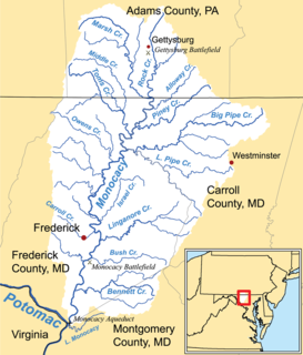
Linganore Creek is a 13.5-mile-long (21.7 km) tributary of the Monocacy River in Frederick County, Maryland. The stream is formed from the confluence of the north and south forks of the Linganore, about 10 miles (16 km) east-northeast of the city of Frederick. The creek runs roughly southwest to the Monocacy River, which drains to the Potomac River. The watershed area of the creek is 83.1 square miles (215 km2). High water in the creek can result in flooding of Gas House Pike, an east-west road running between Monocacy Boulevard and Green Valley Road.
Muddy Branch is a tributary stream of the Potomac River in Montgomery County, Maryland, United States, located about 14 miles (23 km) northwest of Washington, D.C.
Cedar Grove is an unincorporated community in Washington County, Maryland, United States and can be found on the National Register of Historic Places. The community lies about two miles south of MD Route 63 when traveling between Williamsport and Downsville, Maryland; it is located along the northern bank of the Potomac River just opposite the Whiting's Neck promontory.
Double Pipe Creek, sometimes called Pipe Creek, is a major tributary of the Monocacy River in Carroll County and Frederick County in Maryland, located several miles north and west of Westminster. The creek is only 1.6 miles (2.6 km) long, but is formed by the confluence of two much longer streams, Big Pipe Creek and Little Pipe Creek.

Tuscarora Creek is a 12.8-mile-long (20.6 km) tributary of the Potomac River in Frederick County, Maryland, in the United States.
Lowes Island is a census-designated place (CDP) in Loudoun County, Virginia. The population as of the 2010 United States Census was 10,756. Along with nearby Countryside and Cascades, it's considered one of the three main components of the Potomac Falls community.
Sugarland Run is a planned community in Loudoun County, Virginia. The population as of the 2010 United States Census was 11,799. It is north of State Route 7 and south of the Potomac River. Sugarland Run flows along the east side of the community. It is near Northern Virginia Community College – Sterling (NOVA). Sugarland Run is part of the Washington D.C. metropolitan area and is 25 miles west of D.C.


