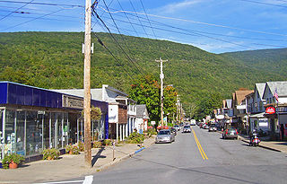
Phoenicia is a hamlet of Shandaken in Ulster County, New York, United States. The population was 309 at the 2010 census, making it the highest populated community in the town. The village center is located just off Route 28 at its junction with Route 214 and is nestled at the base of three peaks, Mount Tremper, Romer Mountain, and Sheridan Mountain. The community sits at the confluence of the Esopus Creek and Stony Clove Creek. A popular getaway for New Yorkers, the hamlet has frequented many tourism guides as among the best vacation towns in the greater New York City area.

The Catskill Mountains, also known as the Catskills, are a physiographic province of the larger Appalachian Mountains, located in southeastern New York. As a cultural and geographic region, the Catskills are generally defined as those areas close to or within the borders of the Catskill Park, a 700,000-acre (2,800 km2) forest preserve forever protected from many forms of development under New York state law.

Bluestone is a cultural or commercial name for a number of dimension or building stone varieties, including:

The Blackhead Mountains range is located near the northern end of the Catskill Mountains, in Greene County, New York, United States, where it divides the towns of Windham and Jewett. The three named peaks in the range — Thomas Cole Mountain, Black Dome, and Blackhead Mountain — are the fourth-, third-, and fifth-highest peaks in the Catskills, respectively. The gap between Thomas Cole and Black Dome is, at 3,700 feet, the highest in the Catskills.
Panther Mountain is one of the Catskill High Peaks, located in the Town of Shandaken in Ulster County, New York. At approximately 3,720 feet (1,130 m) in elevation, it is the 18th highest in the range. A combination of factors has led geologists to believe the mountain is on the site of an ancient meteorite impact crater.

Blackhead is a mountain located in Greene County, New York. The mountain is part of the Blackhead range of the Catskill Mountains. Blackhead is flanked to the northeast by Black Dome and Acra Point is located north.

Vly Mountain is a mountain located in the town of Halcott, New York, United States in Greene County. The mountain is part of the Catskill Mountains. Vly Mountain is flanked to the northwest by Bearpen Mountain, to the east by Vinegar Hill, to the northeast by Kipp Hill, and to the southeast by Beech Ridge.

Halcott Mountain is one of the Catskill Mountains of the U.S. state of New York. It is mostly located in Greene County, with some of its lower slopes in Delaware and Ulster counties. Its exact summit elevation has not been officially determined, but the highest contour line on the mountain is 3,520 feet (1,070 m). It is one of the peaks on the divide between the Delaware and Hudson watersheds.

Balsam Mountain is one of the High Peaks of the Catskill Mountains in the U.S. state of New York. Its exact height has not been determined, so the highest contour line, 3,600 feet (1,100 m), is usually given as its elevation. It is located in western Ulster County, on the divide between the Hudson and Delaware watersheds. The summit and western slopes of the peak are within the Town of Hardenburgh and its eastern slopes are in Shandaken. The small community of Oliverea is near its base on that side. Most of the mountain is publicly owned, managed by the New York State Department of Environmental Conservation as part of the state Forest Preserve, part of the Big Indian-Beaverkill Range Wilderness Area in the Catskill Park. The summit is on a small corner of private land.

Balsam Lake Mountain is one of the Catskill Mountains, located in the Town of Hardenburgh, New York, United States. It is the westernmost of the range's 35 High Peaks. Its exact height has not been determined, but the highest contour line on topographic maps, 3,720 feet (1,130 m), is usually given as its elevation.

Brace Mountain is the peak of a ridge in the southern Taconic Mountains, near the tripoint of the U.S. states of New York, Connecticut and Massachusetts. Its 2,311-foot (704 m) main summit is located in New York; it is the highest point in that state's Dutchess County.

Haines Falls is a hamlet located east of Tannersville, New York in the Town of Hunter, in Greene County, New York. Haines Falls is located at 42°11′45″N74°5′49″W. The hamlet of Haines Falls was always a mountain resort town, unlike Hunter and Palenville which had tanneries. Haines Falls is at the head of Kaaterskill Clove and is the former site of the Catskill Mountain House, Kaaterskill Hotel, and Laurel House which sat atop the famous Kaaterskill Falls. In 1825, Thomas Cole, founder of the Hudson River School of landscape painters, did his first Catskill mountain paintings in Haines Falls: Lake with Dead Trees at South Lake and the Kaaterskill Falls.

Overlook Mountain is the southernmost peak of the Catskill Escarpment in the central Catskill Mountains near Woodstock, New York. The centerpiece of the 590-acre (240 ha) Overlook Mountain Wild Forest area of Catskill Park, the mountain is the site of one of the remaining five Catskill Mountain fire towers and the Overlook Mountain House, a hotel which was built at a higher elevation than any other in the range.
The Catskill Mountain fire towers were constructed to facilitate forest fire prevention and control in the Catskill Mountains of New York. 23 towers were built between 1908 and 1950. The towers fell into disuse by the 1970s as fire spotting from airplanes became more effective, and were gradually decommissioned. The Hunter Mountain Fire Tower was the last to be taken out of service in 1990. Most of the towers have been dismantled, but the five remaining towers have been renovated and opened to the public for observation: the aforementioned Hunter Mountain tower, the Balsam Lake Mountain Fire Observation Station, Overlook Mountain Tower in Woodstock, Tremper Mountain Fire Tower in the town of Denning and Red Hill Fire Tower in the town of Shandaken.

Mount Tremper, officially known as Tremper Mountain and originally called Timothyberg, is one of the Catskill Mountains in the U.S. state of New York. It is located near the hamlet of Phoenicia, in the valley of Esopus Creek.
Hooker Mountain is a mountain located in Central New York region of New York by Schenevus, New York.
Red Hill is a mountain located in the Catskill Mountains of New York east-south of Frost Valley. Woodhull Mountain is located northeast of Red Hill.

Van Loan Hill is a mountain in Greene County, New York. It is located in the Catskill Mountains southwest of Maplecrest. Round Hill is located west, Elm Ridge is located north-northeast, and East Jewett Range is located south of Van Loan Hill.

Kalkberg also known as "Collar Back" is a ridge in Greene County, New York, United States. It is located in the Catskill Mountains southeast of Catskill. Kykuit is located east-northeast and Quarry Hill is located north of Kalkberg.

