Railways in Guyana

Last updated

The Railways of Guyana comprised two public railways, the Demerara-Berbice Railway and the Demerara-Essequibo Railway. There are also several industrial railways mainly for the bauxite industry. The Demerara-Berbice Railway is the oldest in South America. None of the railways are in operation in the 21st century.

Contents

Demerara-Berbice railway

Stamp of 1899 depicting Mount Roraima with a Travelling Post Office cancellation of the East Coast Railway British Guiana East Coast Railway TPO.jpg
Stamp of 1899 depicting Mount Roraima with a Travelling Post Office cancellation of the East Coast Railway

The Demerara-Berbice Railway, built in then British Guiana (now Guyana), was the first railway system on the South American continent. [1] It was 4 ft 8½ ins (1,435 mm) standard gauge and first operated by the Demerara Railway Company, a private concern, but sold to the Colonial Transport Department of the Government, which assumed control from 1 January 1922. [1]

Route

The railway ran for 97.4 kilometres (60.5 mi) along the coast from the capital and main port Georgetown in Demerara to Rosignol in Berbice, [2] whence it was connected by ferry steamer across the Berbice River to New Amsterdam.

History

The bill proposing the construction of the railway was passed in July 1846. [1] The railway was designed, surveyed and built by the British-American architect and artist Frederick Catherwood. All the railway stations, bridges, stores and other facilities were constructed by John Bradshaw Sharples. [3] Financing was provided by the Demerera Sugar Company who wished to transport their product to the dock of Georgetown. Construction was in sections with the first, from Georgetown to Plaisance, opening on 3 November 1848. The opening day's festivities featured the death of one of the railway's directors by being run over by the locomotive.

An extension to Belfield was completed in 1854, to Mahaica in 1864 and finally to Rosignol during 1897–1900.

In 1948 the railway system in Bermuda was dismantled and sold 'lock, stock & barrel' to the government of British Guiana (as the country then was) to rejuvenate the former system. The locomotives (petrol or diesel [just 2]) and coaches were fully restored, the latter being painted dark green. In 1953 the public lines in the colony carried 1,772,954 passengers and 92,769 tonnes of freight. A bold plan to extend the railway south to Brazil was never proceeded with.

The public railway system was dismantled in stages by then President Forbes Burnham, and closed in 1972. [4]

The Lamaha Street terminus of the Demerara-Berbice Railway was converted into a bus terminal subsequent to the closing of the railway.

Service

Following the opening in 1848, there were two return trains per day between Georgetown and Plaisance. [5]

In 1922 there was one train each week day, departing Georgetown at 08:00 and returning in the evening. [2]

The Georgetown-Rosignol railway service ended in 1972.
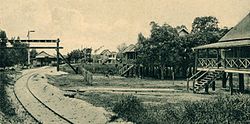
Infrastructure

There were three major bridges on the line, all constructed of steel, across the Mahaica, Mahaicony and Abary Rivers. [5]

There were seventeen stations on the Demerara-Berbice Railway: [6]

Rolling stock

In 1936, the Colonial Transport Department owned 16 locomotives, 39 coaches and 283 goods wagons. [7]

Locomotives

AcquiredDisposedNameNumberCostUseNotes
1847Mosquito [5]
1847Sandfly [5]
1847Firefly [5]
1863Alexandra£1,593Relief engine [8]
18631921Victoria£1,593 [8]
1924Sir Wilfred30 [9]
1924Sir Graeme31 [9] [10]
1946Sir Gordon34 [9]
1946Sir John35 [9]

Demerara-Essequibo railway

Route

'Steam Slide Cecil Rhodes' at the Demerara Essequibo Railway near Wismar on the Demerara River Demerara-essequibo-railway-at-british-guiana-wismar-demerara-river.jpg
'Steam Slide Cecil Rhodes' at the Demerara Essequibo Railway near Wismar on the Demerara River
Rockstone River Terminus of the Demerara Essequibo Railway on the Essequibo River Essequibo-river-rockstone-terminus-of-sprostons-railway.jpg
Rockstone River Terminus of the Demerara Essequibo Railway on the Essequibo River

Guyana's second railway, the Demerara-Essequibo Railway, was 3ft 6ins (1067mm) gauge and ran for 29.8 km (18.5 mi) [2] along the West Coast of Demerara from Vreed en Hoop on the left bank of the Demerara River to Parika on the Essequibo River.

History

Its first section was laid from Vreed-en-Hoop to Greenwich Park c1899 and it was extended to Parika in 1914.

The Demerara-Essequibo railway service ended in 1974.

Service

In 1922 there were three return trains each day, timed to interconnect with arriving and departing steam ferries. [2]

Infrastructure

By 1974 there were eight railway stations along the Demerara-Essequibo line: [6]

A number of minor stops, called platforms, were located between the stations, e.g., at Crane, Blankenberg, Den Amstel, Cornelia Ida, Stewartville, De Willem, Farm.

There was one railway bridge of steel construction across the Boeraserie River.

Industrial railways

The industrial railway systems continued to operate following the closure of the public system and included several at bauxite mining sites and another linking Port Kaituma and Matthew's Ridge in the Northwest District.

In 1897, [11] a 29.8-kilometre (18.5 mi)1,000 mm (3 ft 3+38 in) (metre gauge) industrial railway was built between Rockstone and Wismar (nowadays called Linden) across the watershed between the Demerara and Essequibo Rivers. [12] The Essequibo River was hard to navigate, but the Demerara River was suitable for ocean-going ships. The railway line gave access to the gold fields, balatá and hardwood plantations. In 1936, the company owned 14 locomotives and 272 goods wagons. [7] The railway was closed in the 1940s. [11]

Bibliography

See also

Related Research Articles

The transport sector comprises the physical infrastructure, docks and vehicle, terminals, fleets, ancillary equipment and service delivery of all the various modes of transport operating in Guyana. The transport services, transport agencies providing these services, the organizations and people who plan, build, maintain, and operate the system, and the policies that mold its development.

<span class="mw-page-title-main">British Guiana</span> British colony from 1814 to 1966

British Guiana was a British colony, part of the mainland British West Indies, which resides on the northern coast of South America. Since 1966 it has been known as the independent nation of Guyana.

<span class="mw-page-title-main">Regions of Guyana</span>

Guyana is divided into 10 regions:

<span class="mw-page-title-main">Demerara</span> 1745–1803 Dutch colony in South America

Demerara is a historical region in the Guianas, on the north coast of South America, now part of the country of Guyana. It was a colony of the Dutch West India Company between 1745 and 1792 and a colony of the Dutch state from 1792 until 1815. It was merged with Essequibo in 1812 by the British who took control. It formally became a British colony in 1815 until Demerara-Essequibo was merged with Berbice to form the colony of British Guiana in 1831. In 1838, it became a county of British Guiana until 1958. In 1966, British Guiana gained independence as Guyana and in 1970 it became a republic as the Co-operative Republic of Guyana. It was located around the lower course of the Demerara River, and its main settlement was Georgetown.

<span class="mw-page-title-main">Berbice River</span> River in eastern Guyana

The Berbice River, located in eastern Guyana, is one of the country's major rivers. It rises in the highlands of the Rupununi region and flows northward for 595 kilometres (370 mi) through dense forests to the coastal plain. The river's tidal limit is between 160 and 320 km (99–199 mi) from the sea.

<span class="mw-page-title-main">Demerara River</span> River in Guyana

The Demerara River is a river in eastern Guyana that rises in the central rainforests of the country and flows to the north for 346 kilometres until it reaches the Atlantic Ocean. Georgetown, Guyana's largest seaport and capital, is situated on the east bank of the river's mouth. The river divides Essequibo Islands-West Demerara on the west bank from Demerara-Mahaica to the east.

<span class="mw-page-title-main">Linden, Guyana</span> Town and regional capital in Upper Demerara-Berbice, Guyana

Linden is the second largest city in Guyana after Georgetown, and capital of the Upper Demerara-Berbice region, located at 6°0′0″N58°18′0″W, altitude 48 m (160 ft). It was declared a town in 1970, and includes the communities of MacKenzie, Christianburg, and Wismar. It lies on the Demerara River and has a population of 27,277 as of 2012. It is primarily a bauxite mining town, containing many mines 60–90 m deep, with many other pits now in disuse.

<span class="mw-page-title-main">Demerara-Mahaica</span> Region of Guyana

Demerara-Mahaica is a region of Guyana, bordering the Atlantic Ocean to the north, the region of Mahaica-Berbice to the east, the region of Upper Demerara-Berbice to the south and the region of Essequibo Islands-West Demerara to the west.

<span class="mw-page-title-main">Essequibo Islands-West Demerara</span> Region of Guyana

Essequibo Islands-West Demerara is a region of Guyana. It is situated around the Essequibo River, the largest river in Guyana that lies between the Orinoco and Amazon rivers of South America.

Rosignol is a village on the west bank of the Berbice River in Mahaica-Berbice, Guyana.

<span class="mw-page-title-main">Parika</span> Place in Essequibo Islands-West Demerara, Guyana

Parika is a port village located in the Essequibo Islands-West Demerara region of Guyana. Its ferry service is operated by the Ministry of Transportation, to and from the Essequibo Islands and West Demerara area. It is a hub for land transport, since it is a route stop for local taxis commonly called "buses."

<span class="mw-page-title-main">Upper Demerara-Berbice</span> Region of Guyana

Upper Demerara-Berbice is a region of Guyana, bordering the regions of Essequibo Islands-West Demerara, Demerara-Mahaica and Mahaica-Berbice to the north, the region of East Berbice-Corentyne to the east, and the regions of Potaro-Siparuni and Cuyuni-Mazaruni to the west.

The Abary River is a small river in northern Guyana that drains into the Atlantic Ocean.

The Mahaica River is a small river in northern Guyana that drains into the Atlantic Ocean. The village of Mahaica is found at its mouth.

<span class="mw-page-title-main">Mahaicony</span> Place in Mahaica-Berbice, Guyana

Mahaicony is a community that is made up of several villages in East Coast Demerara, Mahaica-Berbice, Guyana. Mahaicony's physical boundaries on the coast is from De Hoop village in the west to Calcutta village in the east.

Vreed en Hoop is a village at the mouth of the Demerara River on its west bank, in the Essequibo Islands-West Demerara region of Guyana, located at sea level. It is the location of the Regional Democratic Council office making it the administrative center for the region. There is also a police station, magistrate's court and post office.

<span class="mw-page-title-main">Rockstone</span> Village in Upper Demerara-Berbice, Guyana

Rockstone is a village on the right bank of the Essequibo River in the Upper Demerara-Berbice Region of Guyana, altitude 6 metres. Rockstone is approximately 26 km west of Linden and is linked by road.

Den Amstel is a village in Guyana's Essequibo Islands-West Demerara region. It lies on the Atlantic coast, approximately 13 kilometres (8.1 mi) west-north-west of the capital, Georgetown. The village has a population of 938 people as of 2012, who are predominantly Afro-Guyanese.

Helena is a village in the Demerara-Mahaica Region of Guyana. Administratively the village is subdivided in Helena No.1 and Helena No.2 and is part of the Mahaica subregion.

References

  1. 1 2 3 "The Old Railway Station, Lamaha Street, Cummingsburg". Georgetown, Guyana: National Trust of Guyana. Archived from the original on 17 May 2009. Retrieved 7 November 2009.
  2. 1 2 3 4 The British Guiana Handbook 1922. 29 September 2009.
  3. Hernandez, Lennox J (29 September 2009). "Architecture... Sharples house, Duke Street, Kingston: an icon of our wooden building heritage". Stabroek News . Retrieved 7 November 2009.
  4. "The Public Railways of Guyana, 2014, Part 1". International Steam. Retrieved 4 December 2021.
  5. 1 2 3 4 5 The early period of road and railway transport, Chapter 73, Guyana History, Guyana News and Information.
  6. 1 2 Young, J. Allan E. (January 1964). "The British Guiana Government Railways: The Development of British Guiana's Public Railways During 115 Years". Railway Magazine. Vol. 110, no. 753. pp. 174–181.
  7. 1 2 World Survey of Foreign Railways. Transportation Division, Bureau of foreign and domestic commerce, Washington D.C. 1936. p. 35.
  8. 1 2 History of the British Guiana Railway System – Georgetown to Mahaica, Part 4, Stabroek News, 2009-07-09.
  9. 1 2 3 4 "4-6-4 Locomotives in British_Guiana". steamlocomotive.com. Retrieved 1 March 2023.
  10. "British Guyana Railway - 4-6-4T steam locomotive Nr. 31 "Sir Graeme"". Historical Railway Images, Flickr. 20 October 2017. Retrieved 1 March 2023.
  11. 1 2 "THE 1897 WISMAR TO ROCKSTONE RAILWAY". Guyanese Online. 18 May 2012. Retrieved 23 August 2020.
  12. "River transport". Georgetown, Guyana: Stabroek News. 30 July 2009. Retrieved 7 November 2009.