Ramnagar, West Champaran

Last updated

Ramnagar
Town
Shiv Mandir Ramnagar pic credit : Apurv Shrivastva Shiv Mandir Ramnagar.jpg
Shiv Mandir Ramnagar pic credit : Apurv Shrivastva
India Bihar location map.svg
Red pog.svg
Ramnagar
Location in Bihar, India
Coordinates: 27°10′N84°19′E / 27.17°N 84.32°E / 27.17; 84.32
CountryFlag of India.svg  India
State Bihar
District Pashchim Champaran
Government
  TypeDemocratic
Elevation
85 m (279 ft)
Population
 (2011)
  Total249,102
Languages
  OfficialBhojpuri, Hindi, English
Time zone UTC+5:30 (IST)
PIN
845106
ISO 3166 code IN-BR
Lok Sabha constituency Valmiki Nagar
Vidhan Sabha constituency Ramnagar
Website westchamparan.bih.nic.in

Ramnagar is a town and a notified area in Pashchim Champaran district in the Indian state of Bihar. Ramnagar is situated on the border of India-Nepal and Bihar - Uttar Pradesh.

Contents

Demographics

Population

  Male (51.95%)
  Female (48.05%)

Residency

  urban (19.4%)
  Rural (80.6%)

As of 2011, India census, [1] Ramnagar had a population of 249,102 . Males constitute 51.95% of the population and females 48.05%. Ramnagar has an average literacy rate of 55.43%., lower than the national average of 59.5% : The male literacy rate is 52.83% and the female literacy rate is 36.15% in Ramnagar Block. 19% of the population is under 6 years of age. As per Census 2011 out of total population, 19.4% people lives in Urban areas while 80.6% lives in the Rural areas. The average literacy rate in urban areas is 66.4% while that in the rural areas is 52.7%. Also the Sex Ratio of Urban areas in Ramnagar Block is 907 while that of Rural areas is 929.

About

Religion-wise Population Ramnagar

ReligionTotalMaleFemale
Hindu184,918(74.23%)96,40988,509
Muslim63,023(25.3%)32,39530,628
Christian460(0.18%)224236
Sikh86(0.03%)4937
buddhist54(0.02%)2727
Jain30(0.01%)1614
Other religion3(0.00%)30
No religion specified528(0.21%)276252

Urban/Rural Population - Ramnagar

As per Census 2011, there are total 9,123 families under Ramnagar Block living in urban areas while 9,123 families are living within Rural areas. Thus around 19.4% of total population of Ramnagar Block lives in Urban areas while 80.6% lives under Rural areas. Population of children (0 – 6 years) in urban region is 8,146 while that in rural region is 39,558.

TotalUrbenRural
Population249,10248,411200,691
Children (0-6 year)47,7048,14639,558
Schedule Caste41,7743,98637,788
Schedule Tribe39,6321,30638,326
Literacy55.43%66.37%52.69%
Sex Ratio925907929

Working Population - Ramnagar

In Ramnagar Block out of total population, 97,049 were engaged in work activities. 64.1% of workers describe their work as Main Work (Employment or Earning more than 6 Months) while 35.9% were involved in Marginal activity providing livelihood for less than 6 months. Of 97,049 workers engaged in Main Work, 9,933 were cultivators (owner or co-owner) while 38,972 were Agricultural labourer.

Working population
MALENumber
Main workers
47,171
Cultivator
08,689
Agrigulture Labour
28,115
Household industries
00,780
Other Workers
9,587
Marginal Workers
17,213
Non Working
65,015
Working population
FEMALENumber
Main workers
14,990
Cultivator
01,244
Agrigulture Labour
10,857
Household industries
00,289
Other Workers
2,600
Marginal Workers
17,675
Non Working
87,038

Tourism

Place to know in Ramnagar

Chitragupt Mandir

Chitragupt Mandir By Apurv Shrivastva Chitragupt Mandir.jpg
Chitragupt Mandir By Apurv Shrivastva

Chitragupta (Sanskrit: चित्रगुप्त, 'rich in secrets' or 'hidden picture') is a Hindu god assigned with the task of keeping complete records of actions of human beings on the earth and punish or reward them according to their Karmas. He is god of justice therefore known as Dharmaraja. Upon their death, Chitragupta has the task of deciding heaven or the hell for the humans, depending on their actions on the earth. Chitragupta Maharaj is the seventeenth Manasputra of Lord Brahma and thus, allotted the right to write Vedas like Brahmins with the duty of a Kshatriya (Chitragupta is the patron deity of Kayasthas, a Hindu caste of India and Nepal), because of which Chitraguptavanshi Kayasthas are considered as Vedic Suryavanshi Brahmakshatriyas. Chitragupta is god of Kayasth.

Location : Near Busstand , Chitragupt mandir

.........................................................................................................................................................

Nature

Pc: Apurv Sunset at Ramnagar.jpg
Pc: Apurv
Harinagar Station A.jpg

As described above the Nature in Ramnagar is hot in summers and cold in winter like the rest of Bihar.

Climate

The climate of Ramnagar is shown in the chart below. The temperature doesn't remain constant all the year as per chart but follows the climate changes throughout the year Ramnagar weather

Ramnagar
Climate chart (explanation)
J
F
M
A
M
J
J
A
S
O
N
D
 
 
10
 
 
23
11
 
 
20
 
 
26
13
 
 
10
 
 
33
19
 
 
10
 
 
39
25
 
 
20
 
 
42
29
 
 
50
 
 
40
29
 
 
250
 
 
34
26
 
 
240
 
 
32
26
 
 
110
 
 
34
25
 
 
20
 
 
34
22
 
 
10
 
 
30
16
 
 
10
 
 
25
12
Average max. and min. temperatures in °C
Precipitation totals in mm
Source: Ramnagar weather
Imperial conversion
JFMAMJJASOND
 
 
0.4
 
 
74
51
 
 
0.8
 
 
79
55
 
 
0.4
 
 
91
65
 
 
0.4
 
 
101
77
 
 
0.8
 
 
108
85
 
 
2
 
 
103
83
 
 
9.8
 
 
92
79
 
 
9.4
 
 
89
79
 
 
4.3
 
 
94
77
 
 
0.8
 
 
93
72
 
 
0.4
 
 
85
60
 
 
0.4
 
 
77
54
Average max. and min. temperatures in °F
Precipitation totals in inches
Climate data for Ramnagar (A)
MonthJanFebMarAprMayJunJulAugSepOctNovDecYear
Record high °C (°F)33.4
(92.1)
37.0
(98.6)
42.7
(108.9)
48.5
(119.3)
48.4
(119.1)
47.3
(117.1)
44.3
(111.7)
41.0
(105.8)
41.0
(105.8)
40.4
(104.7)
38.0
(100.4)
33.2
(91.8)
48.5
(119.3)
Mean daily maximum °C (°F)23.7
(74.7)
26.9
(80.4)
32.9
(91.2)
38.8
(101.8)
42.1
(107.8)
40.0
(104.0)
34.2
(93.6)
32.0
(89.6)
33.7
(92.7)
34.3
(93.7)
29.9
(85.8)
25.3
(77.5)
32.8
(91.1)
Mean daily minimum °C (°F)5.9
(42.6)
13.7
(56.7)
19.1
(66.4)
25.0
(77.0)
29.3
(84.7)
29.2
(84.6)
26.5
(79.7)
25.4
(77.7)
25.0
(77.0)
11.8
(53.2)
7.3
(45.1)
6.9
(44.4)
18.8
(65.8)
Record low °C (°F)1.7
(35.1)
4.5
(40.1)
8.6
(47.5)
14.0
(57.2)
20.0
(68.0)
18.8
(65.8)
20.4
(68.7)
18.4
(65.1)
16.4
(61.5)
14.1
(57.4)
7.1
(44.8)
3.8
(38.8)
1.7
(35.1)
Average precipitation mm (inches)5.4
(0.21)
4.4
(0.17)
4.0
(0.16)
3.2
(0.13)
10.3
(0.41)
62.9
(2.48)
257.0
(10.12)
245.8
(9.68)
98.5
(3.88)
19.6
(0.77)
7.8
(0.31)
3.5
(0.14)
722.4
(28.46)
Average rainy days0.91.00.60.42.16.913.115.25.61.61.20.549.1
Average relative humidity (%)48382519234367745840414844
Source: Ramnagar weather, India Meteorological Department: (Ramnagar (A) record highs and lows up to 2010), [4] Monthly mean maximum and minimum temperature and rainfall (1961-2000) EDITED by: APURV SHRIVASTVA [5]

Related Research Articles

<span class="mw-page-title-main">Sheohar district</span> District of Bihar in India

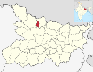
Sheohar is an administrative district in the Mithila region of Bihar in India. The district headquarters are located at Sheohar, and the district is a part of Tirhut Division. This district was carved out of Sitamarhi district in 1994 due to the extreme efforts of Raghunath Jha, former Union Minister. Eminent Hindi Novelist, Dr. Bhagwati Sharan Mishra was the first District magistrate of Sheohar . Sivas used to have a guest house in the Mehsi town of his time, which is still located in the name of Raja Bazar in East Champaran.The district occupies an area of 349 km2 and has a population of 656,246. Sheohar is known for its greenery and cleanliness. Cadamba and teak are the principal trees of this district. Nilgai or blue bull is the regional animal of this area.

<span class="mw-page-title-main">West Champaran district</span> District in Bihar, India

West Champaran is an administrative district in the state of Bihar in India, located just 60 km (37 mi) west of Birgunj. It is the largest district in Bihar with an area of 5,228 km2(2,019sq mi). It is a part of Tirhut Division. The district headquarters are located in Bettiah. The district is known for its open border with Nepal. One of the major location in West Champaran is Kumar Bagh for SAIL Special Processing Unit and Bhitiharwa where Mahatma Gandhi started Satyagrah Aandolan.

<span class="mw-page-title-main">East Champaran district</span> District of Bihar in India

East Champaran is an administrative district in the state of Bihar in India.The district headquarters are located at Motihari. Prior to 1971, there was a single district called "Champaran". On 1 December 1971, the district was divided into 2 parts East Champaran and West Champaran. In early days the land of East Chamapran was ruled by different kingdoms as Videha, Sunga, Kanvas. It is also believed that Champaran used to be a major part of King Janak's empire. Mahatma Gandhi started his famous Satyagraha movement from here.

<span class="mw-page-title-main">Bettiah</span> City in Bihar, India

Bettiah is a city and the administrative headquarters of West Champaran district - (Tirhut). It is near the Indo-Nepal border, 225 kilometres (140 mi) northwest of Patna, in the state of Bihar, India.

<span class="mw-page-title-main">Madhepura district</span> District of Bihar in India

Madhepura district is one of the thirty-eight districts of Bihar state, India, and Madhepura town is the administrative headquarters of this district. Madhepura district is a part of Kosi division.

<span class="mw-page-title-main">Madhubani district</span> District in Bihar, India

Madhubani district is one of the thirty-eight districts of Bihar, India, and is a part of Darbhanga division. Its administrative headquarters are located in Madhubani. The district has an area of 3,501 square kilometres (1,352 sq mi) and has a population of 4,487,379.

<span class="mw-page-title-main">Supaul district</span> District of Bihar, India

Supaul district is one of the thirty-eight districts of Bihar, India. The town Supaul is the district's administrative headquarters. The district, which was split from the former Saharsa district on 14 March 1991, occupies 2,410 km2 (931 sq mi).

<span class="mw-page-title-main">Sitamarhi district</span> District of Bihar in India

Sitamarhi is one of the districts in the Mithila region of the Indian state of Bihar, India. Dumra is the administrative headquarters of this district. The district is a part of the Tirhut Division and is located along the border of Nepal.

<span class="mw-page-title-main">Aurangabad district, Bihar</span> District of Bihar in India

Aurangabad district is one of the thirty-eight districts of Bihar state, India. It is currently a part of the Red Corridor.

<span class="mw-page-title-main">Koderma district</span> District of Jharkhand in India

Koderma district is one of the twenty-four districts of Jharkhand state, India, and Koderma is the administrative headquarters of this district.

<span class="mw-page-title-main">Jharsuguda district</span> District in Odisha, India

Jharsuguda is a district in Odisha, India with Jharsuguda town as its headquarters. This region is rich in coal and other mineral reserves. Of late, many small and medium scale iron and steel units have been set up in the vicinity of Jharsuguda town, giving impetus to the industrial growth of the district.

<span class="mw-page-title-main">Maharajganj district</span> District of Uttar Pradesh in India

Maharajganj district is one of the 75 districts of Uttar Pradesh state in northern India, and the town of Maharajganj is the district headquarters. District is a part Gorakhpur division. It is located in Terai region of Himalayas, bordering Nepal in North. Gandak, Rapti, Rohin are some major river flowing through the district.

<span class="mw-page-title-main">Bhadohi district</span> District in Uttar Pradesh, India

Bhadohi district is a district of Uttar Pradesh state in northern India. It is also referred to as Sant Ravidas Nagar. It is the smallest district by area in the state of Uttar Pradesh which was created on June 30, 1994 by dividing western part of the district Varanasi. It is surrounded by Varanasi district on east, Allahabad on west, Jaunpur north and Mirzapur district in south. The state capital Lucknow is distanced at 234 KM from Bhadohi. Its district headquarters is situated in the city of Gyanpur. The district is popularly known for carpet weaving as it is one of largest centres of Carpet Industries in India and therefore it also known as the 'Carpet City of India'. Carpets of Bhadohi have 'Geographical Indication' tag attached to it. Bhadohi has huge geographical significance and position attached to it due to its location between two culturally important and rich heritage cities of Prayagraj and Varanasi.

<span class="mw-page-title-main">Jaspur</span> Town in Uttarakhand, India

Jaspur is a developing town and a municipal board in Udham Singh Nagar district in the Indian state of Uttarakhand.

<span class="mw-page-title-main">Nokha, Rohtas</span> Town in Bihar, India

Nokha is a nagar panchayat town and corresponding community development block in Rohtas district in the Indian state of Bihar. As of 2011, the population of the town of Nokha was 27,302 in 4,381 households. The rural population of Nokha block was 146,025, thus bringing the total block population 173,327. The economic situation of this region is mainly dependent on parboiled rice processed by number of rice mills in this area.

<span class="mw-page-title-main">Tilouthu</span> Town in Bihar, India

Tilothu, also spelled Tilauthu or Tilothu, is a village and corresponding community development block in Rohtas district, Bihar, India. It is located 15 km from Dehri-on-Sone on the west bank of the Son River. As of 2011, the population of Tilouthu was 16,402, in 2,745 families, while the corresponding block population was 109,249.

<span class="mw-page-title-main">Saran district</span> District in Bihar, India

Saran district is one of the 38 districts of Indian state of Bihar. The district, part of Saran Division, is also known as Chhapra district after the headquarters of the district, Chhapra.

Jihuli is a village in the East Champaran district of Bihar, India.

Harinagar is a rural municipality (gaunpalika) out of six rural municipality located in Sunsari District of Koshi Province of Nepal. There are a total of 12 municipalities in Sunsari in which 6 are urban and 6 are rural.

Pacharauta is a municipality in Bara District in Province No. 2 of South-Eastern Nepal. It was formed in 2016 occupying current 9 sections (wards) from previous 9 former VDCs. It occupies an area of 44.01 km2 with a total population of 34,175.

References

  1. "Census-2011, Paschim Champaran" (PDF). Census Commission of India.
  2. "shiv mandir in Bihar (Ramnagar)" . Retrieved 21 March 2018.
  3. "Places of Toutist & Historic Importance". westchamparan.bih.nic.in. Retrieved 21 March 2018.
  4. "Ever Recorded Maximum Temperature, Minimum Temperature and 24 Hours Heaviest Rainfall up to 2010" (PDF). India Meteorological Department. p. 64. Archived from the original (PDF) on 16 March 2014. Retrieved 20 May 2016.
  5. "Monthly mean maximum & minimum temperature and total rainfall based upon 1901-2000 data" (PDF). India Meteorological Department. p. 38. Archived from the original (PDF) on 11 April 2016. Retrieved 6 June 2016.